

A volume number isn’t proof that a stockpile changed. Drone volume calculations construction teams can rely on start with a clearly defined base surface and repeatable aerial capture, not a one-click result. If the baseline shifts between visits, the comparison can mislead even when the map looks detailed.
How do aerial images become a quantity, and how can you review that quantity? A drone captures overlapping images. Processing turns them into mapped surface data, and software compares the measured surface with a selected base to calculate volume. Capture conditions, surface visibility, and baseline selection can all affect the result. The assumptions matter as much as the output.
This guide explains the measurement process, what can affect results, and how to prepare a site for repeatable tracking. You’ll also see how volumetric measurements support construction intelligence alongside aerial documentation and progress reports. TDB Solutions serves construction teams in Houston, Friendswood, Pearland, Galveston, and League City. FAA Part 107 certified pilots and over 10 years of survey experience support its site data work.
Key Takeaways
- Separate stockpile volume from cut-and-fill quantities so you measure the change your project needs to track.
- See how drone volume calculations turn site data into a volume estimate by comparing a measured surface with a defined reference.
- Understand why surface visibility, measurement boundaries, capture conditions, and baseline selection can affect the result.
- Set up repeat visits by identifying the stockpile or earthwork area and keeping the measurement approach consistent.
- Pair volumetric measurements with aerial documentation and progress reports for clearer construction oversight.
What drone volume calculations reveal about construction sites
A drone volume calculation estimates the space occupied by material or earth within a defined area, using captured data to model the site surface. The result depends on the surface represented in the data and the boundary selected for measurement. It estimates volume. It does not establish legal property boundaries or replace licensed land surveying.
“Volume” can describe different construction questions. A stockpile measurement estimates the material occupying a bounded three-dimensional shape. A cut-and-fill calculation compares existing ground with proposed surface levels to estimate where earth may need to be removed or added. A repeat measurement compares documented site conditions from different visits. Each answers a different question, so define the quantity you need before reviewing a result.
Which construction quantities can drone data help measure?
On a Houston-area jobsite, your team might track an aggregate stockpile separately from grading progress across an earthwork area. The first measurement focuses on the pile’s shape and defined footprint. The second relates existing ground levels to a proposed surface. An Aerial survey using UAVs collects aerial data that can support this kind of mapped surface analysis.
Repeat visits add a time dimension. Compare measurements of the same stockpile or work area, using consistent boundaries and a comparable reference surface, to review changes between documented dates. This comparison can inform discussions about material on site or earthwork progress. A volume estimate gives a geometric quantity, not a weight or a complete material inventory. Those require other project information.
How volume measurements support project oversight
Quantities help project teams discuss what is present and how site conditions are changing. A dated aerial record puts a volume estimate in context: which area was measured, what surface formed the reference, and when the data was captured. Review that context alongside progress reports and other jobsite records rather than treating the number as a standalone answer.
Connect each measurement to a practical decision. Are you checking a stockpile, reviewing earthwork against a proposed surface, or comparing site conditions between visits? State the purpose clearly, then keep the area and reference approach consistent when making comparisons. For example, a dated record of a designated material pile on a Houston-area site can support a review of changing quantities.
Think of the calculation as one part of site intelligence. It provides a structured way to discuss surface-based quantities, while aerial documentation and progress reports show the wider site context. Clear definitions make the estimate easier to interpret, compare, and use in project discussions.
How drone data becomes a construction volume calculation
A useful volume result begins before the drone leaves the ground. First, define the measurement question and plan the area to capture. After the flight, processing turns the collected imagery or other suitable data into a measurable representation of the site. The calculation compares that surface with a selected base or reference surface within a defined boundary.
Here’s the workflow:
- Plan the capture. Identify the stockpile or earthwork area and the site coverage needed to represent it.
- Collect site data. Capture overlapping aerial imagery or other suitable data across the target area.
- Process the surface. Build a mapped representation of the ground and visible material from the captured data.
- Set the boundary and base. Define the measurement area, then select the reference surface for comparison.
- Calculate and review. Compare the measured surface with the reference to estimate volume above or below it.
An orthomosaic is a geometrically corrected aerial image composed of many photos, providing uniform scale for accurate measurements. It lets teams view the site as a consistent map rather than a set of separate images. Digital surface models are raster models representing the earth’s surface, used for tasks such as drainage analysis and grading verification. A surface model can represent elevations for comparison with the calculation’s base.
Why the measurement boundary and base surface matter
The boundary determines what enters the calculation. If it cuts across a pile’s edge, the measured area may exclude material or include ground beyond the intended stockpile. The base surface defines the reference beneath or through the measured surface. A flat, clearly defined reference may suit some stockpile measurements. Uneven surrounding ground can make the choice less straightforward. Both the boundary and base shape the reported volume.
For cut-and-fill, the reference may be a proposed design surface. For a stockpile, it may represent the ground beneath the pile. Those choices answer different questions. If pile edges blend into nearby material or the underlying ground varies, define the boundary and baseline carefully instead of drawing an arbitrary outline.
From captured data to a usable site record
Processing turns captured data into surfaces that can be measured and reviewed. An orthomosaic helps orient the team, while a digital surface model represents elevation. The boundary and reference connect those products to the specific quantity your team wants to understand.
A volume calculation needs captured site-surface data, a defined measurement boundary, and a selected base or reference surface. Those inputs are essential, but they don’t guarantee a particular level of accuracy. Keep them clear in the site record so the estimate has context for project discussions. TDB Solutions includes volumetric measurements in construction intelligence alongside aerial documentation and progress reports. To plan a site measurement in Greater Houston, explore TDB Solutions.
What affects drone volume accuracy on a construction site?
A drone capture doesn’t make a volume estimate automatically reliable. The result depends on the site data, visible surface, measurement boundary, and reference surface used in processing. A clear-looking map can still produce a misleading quantity if the data misses part of a pile or the baseline doesn’t represent the ground beneath it.
Site conditions matter. Vegetation can hide the ground or material surface the calculation needs to represent. Shade and complex terrain can affect which capture method suits the job. Processing decisions matter too: where the measured area starts and ends, and what base surface the calculation uses. Review these choices alongside the reported volume.
Photogrammetry and LiDAR: what changes in the workflow?
Photogrammetry derives surface information from overlapping photographs. Processing matches features across images to build a site representation. LiDAR records surface information using a different capture method. Neither method is right for every site. Vegetation, shade, and complex terrain can affect suitability, so the goal is to capture a surface that represents the measured area.
For an exposed stockpile, photographs may provide useful surface detail. If vegetation obscures the ground or terrain changes sharply, account for those conditions in the capture plan and method. The method alone won’t resolve an unclear pile edge or an unsuitable baseline. Review whether the captured surface represents the target area and whether the reference fits the measurement question.
How to interpret accuracy claims responsibly
Accuracy figures describe a particular test, product, or workflow, not every drone measurement. A vendor’s reported comparison with ground-based methods applies to its stated testing and conditions. A separate platform’s accuracy claim belongs to that product and its described workflow. Neither is a universal guarantee for a different site, sensor, capture plan, or processing setup.
No single accuracy figure fits every drone volume workflow because site conditions, surface visibility, measurement boundaries, reference surfaces, and processing assumptions vary. To assess a result, look at what the reported figure measures, how the data was captured, and whether those conditions apply to your project. A result for internal progress discussions may serve a different purpose from data that must align with a design or coordinate system. Ground control or RTK/PPK workflows can help tie data to known coordinates, but they don’t remove every source of uncertainty.
Drone volume measurements support construction oversight, but they don’t replace licensed land surveying. Keep the intended use clear: a volume estimate can inform project discussions, while licensed land surveying addresses different professional requirements. For drone volume calculations your team can review responsibly, document site conditions, capture method, boundary, and baseline alongside the result. That context helps you interpret the number rather than relying on it alone.
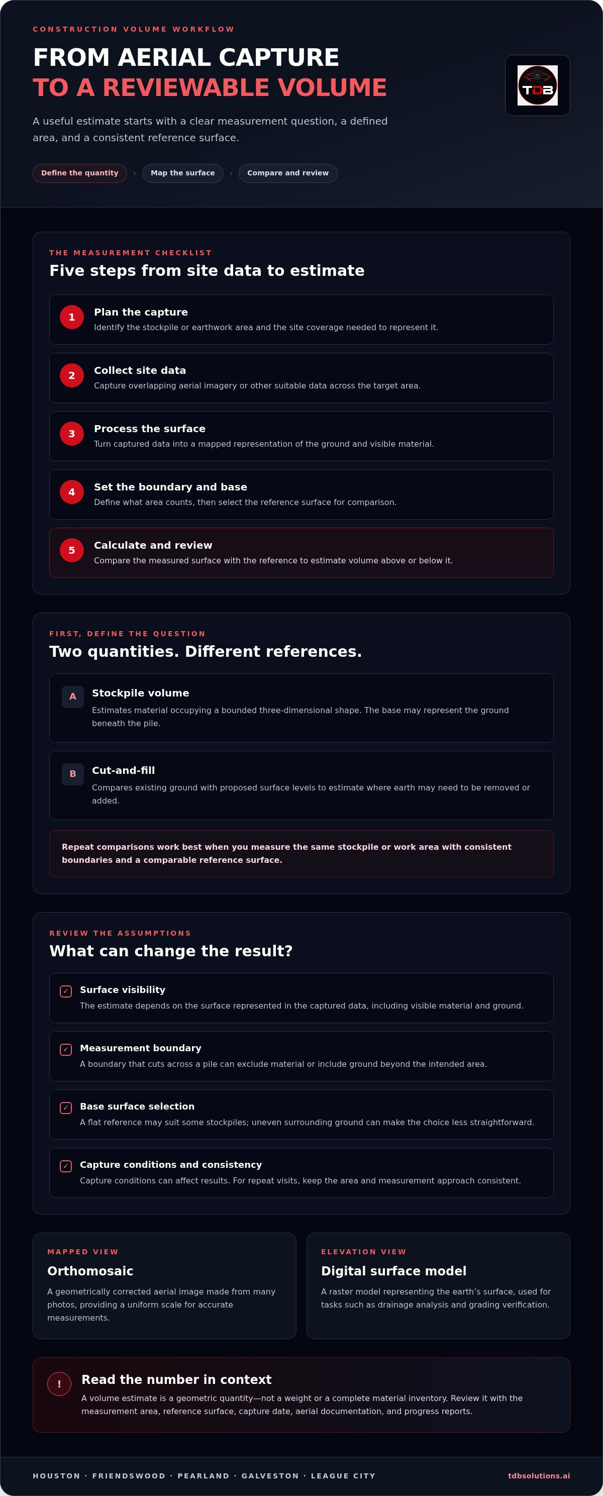
A practical workflow for repeatable construction volume measurements
Repeatable measurements start with a clear question, not a flight schedule. Decide what your team needs to understand, then keep the capture area, boundary, and reference approach consistent across visits. This gives you a clearer basis for comparing site records and discussing changes with project stakeholders.
Use this workflow for drone volume calculations on your construction site:
- Choose the measurement purpose. Specify whether you need a stockpile quantity, a cut-and-fill view, or a record of change between visits.
- Identify the target. Mark the stockpile or earthwork area and define the boundary before capture. For a plan comparison, identify the relevant design surface or plan context.
- Set the reference. Record the base surface or design reference that gives the result meaning. A stockpile and a grading review may require different references.
- Capture and process the site. Collect aerial data for the defined area and turn it into a measurable surface representation.
- Review the record. Check the date, measured area, boundary, reference, and result together before comparing it with another visit.
Prepare the site and define the measurement question
Preparation helps prevent mismatched measurements. If you’re tracking a stockpile, identify the specific pile and where its footprint ends. If you’re reviewing earthwork, define the work area and the proposed surface that provides context. A plan comparison also needs a clear relationship between the captured site data and the plan being reviewed. Record these choices before capture, not after a result raises questions.
For a repeat visit, preserve the same measurement intent. If the target changes from a stockpile to the surrounding pad, the new calculation won’t answer the same question. Conditions may change, but a documented boundary and reference help your team distinguish site changes from changes in the measurement setup.
Review and compare results across visits
Keep the capture date and measurement boundary visible in project records. When you compare visits, use like-for-like areas and reference surfaces wherever the project question calls for a direct comparison. If either changes, document it so the team knows the comparison has a different basis. Review the mapped surface and site context alongside the quantity, rather than treating the number as the entire record.
Some construction teams also work with building information modeling. Autodesk Revit is BIM software compatible with drone data outputs, but compatibility doesn’t mean every capture produces a ready-to-use Revit deliverable. Define the intended use when planning the data record.
These habits turn individual measurements into a useful history of site conditions. TDB Solutions brings volumetric measurements together with aerial documentation and progress reports as part of construction intelligence. For broader progress-tracking context, the Construction Intelligence Drone Data article can help you connect repeat site records with project oversight.
How TDB Solutions supports construction volume calculations in Greater Houston
A volume figure is most useful when it fits into a clear jobsite record. TDB Solutions provides construction intelligence that brings volumetric measurements together with aerial documentation, site progress reports, and overhead oversight. Your team can review material quantities alongside the wider site picture.
What TDB Solutions brings to a construction site
TDB Solutions provides volumetric measurements in the context of captured site conditions, connecting a defined area with the project question it needs to address. A stockpile review, earthwork assessment, and progress record serve different needs. Construction intelligence organizes aerial site information around those distinctions, giving project discussions more context than a standalone number.
Construction teams in Houston, Friendswood, Pearland, Galveston, and League City can document material areas and changing site conditions with this approach. Volumetric measurements work alongside aerial documentation and progress reports, giving teams more than a single snapshot to review.
Construction intelligence can extend beyond a single volume calculation. Dated aerial records help teams revisit site conditions and organize progress information for project oversight. TDB Solutions’ construction intelligence services connect aerial data with practical construction documentation.
Move from measurement questions to a project conversation
Before planning a site measurement, identify three things: the quantity or condition you need to review, the area to capture, and how your team will use the result. A stockpile review has a different purpose from a cut-and-fill comparison or a record of changing site conditions. Sharing that context helps frame the capture and resulting record around your project question.
Once the measurement purpose is clear, TDB Solutions can bring volumetric measurements together with aerial documentation and progress reporting. Keep the target area and intended use in view as you plan the work. That gives the project conversation a practical starting point.
Drone volume calculations construction teams can use begin with a defined project need and a clear site area. Talk with TDB Solutions about construction volume measurements and discuss how construction intelligence can fit your project.
Make your next site measurement count
Give the measurement a clear role in your project routine. Decide who will use the information, which upcoming decision it should inform, and how your team will store the record with other job documentation. That turns an isolated figure into a practical reference point for future project conversations.
For drone volume calculations your construction team can put to work, start with the question your site needs answered and the area tied to it. Bring that purpose into a project conversation before the next capture. A clear brief gives the measurement a place in your workflow and helps your team plan how to use the resulting site information.
Talk with TDB Solutions about construction volume measurements and discuss how construction intelligence can fit your project needs. Define the question, then build a site record around it. A clearer view of changing site conditions starts with a focused plan.
Frequently Asked Questions
How do drones calculate stockpile volume?
A drone capture supplies site data that processing software turns into a three-dimensional surface representation. The calculation uses a defined pile area and a reference for the ground beneath or around the material. For a stockpile beside a loading area, the measured boundary should follow the pile rather than include nearby pavement or another pile. Reviewing the mapped outline and reference helps you understand what the reported quantity represents.
Can a drone measure cut-and-fill volumes on a construction site?
Yes. Drone data can support cut-and-fill estimates by comparing the captured ground surface with a proposed design surface. The comparison helps teams see where existing terrain sits above or below the planned grade. For example, a grading review can focus on a defined pad instead of the entire jobsite. The estimate depends on relevant surface data and a suitable plan reference for that area.
What happens if trees or shadows obscure part of a stockpile?
Obstructions can limit how well the captured data represents the pile surface. Trees may hide material, while shadows can make surface details harder to interpret in imagery. Don’t treat an obscured portion as a complete measurement. Flag the affected area in the record and consider whether a different capture approach or another source of site information is needed. The team should understand the limitation before using the quantity in a project discussion.
Can drone volume calculations replace licensed land surveying?
No. Drone volume calculations provide surface-based quantity estimates for construction oversight. They don’t replace licensed land surveying or establish legal property boundaries. If your project needs boundary work or another survey purpose, a volume estimate isn’t a substitute. Use the drone record for the construction question it addresses, such as reviewing a stockpile or earthwork area, and keep its intended use clear in project documentation.
How often should a construction team capture drone data for volume tracking?
Set the capture schedule around the decisions your team needs to make, the pace of site activity, and how often quantities must be reviewed. A stockpile that changes frequently may call for a different cadence than a stable earthwork area. For projects in Houston, Friendswood, Pearland, Galveston, or League City, coordinate visits with reporting milestones or material reviews, then keep the schedule and measurement approach consistent.
Can one drone flight show how much a stockpile has changed over time?
No. One flight records conditions on its capture date, but it can’t establish change without an earlier comparable record. To evaluate movement, compare measurements from separate visits that cover the same pile and use compatible boundaries and references. If the pile’s shape or location changes, note that in the project record. This gives your team context for interpreting the difference between dated measurements.
Do drone volume calculations identify what material is in a stockpile?
No. Volume calculations estimate the space occupied by the visible pile, not its material type, composition, moisture, or weight. A mapped pile can help you track its size, but identifying whether it contains a particular aggregate or soil requires other project information. Pair the geometric estimate with material records when you need to understand both quantity and material identity.


