

What should someone understand about your property, project, or business before they ever set foot on site? The right aerial photos can answer that question. TDB Solutions provides aerial photography services Houston businesses and property owners use to communicate scale, layout, access, and progress clearly. An overhead view can reveal context that ground-level shots miss.
Aerial images can make a listing or project update more useful, but the right results depend on choosing views that fit your audience and intended use. TDB Solutions brings over 10 years of survey experience to each shoot. Every flight is performed by an FAA Part 107 certified pilot with full liability insurance.
This guide explains how aerial photography supports commercial properties, real estate, and project communication across Houston, Friendswood, Pearland, Galveston, and League City. You’ll learn what to prepare, how to choose the right format, and what to expect from delivery. Most shoots are delivered within 24 hours, with turnaround within 24-48 hours of the flight.
Key Takeaways
- Learn how aerial views communicate a property’s scale, layout, location, and surroundings more clearly than ground-level images alone.
- See how aerial photography services Houston can be planned around your audience, intended use, and visual priorities.
- Compare still photos, aerial video, and recurring construction documentation to choose a format that fits your goal.
- Use a focused preparation checklist to identify key structures, access details, and the perspectives that matter before scheduling.
- Explore how TDB Solutions serves Houston-area properties and projects with aerial photography and media production.
What aerial photography services in Houston can show your audience
Aerial photography means photographs captured from an airborne platform to present a property or site from above. One view can bring together the building, its footprint, access points, outdoor areas, and nearby surroundings. For a general overview of the medium and its uses, see Aerial photography. TDB Solutions provides aerial photography services Houston businesses and property teams can use to explain a place clearly, whether they’re sharing a listing, introducing a commercial location, or communicating project progress.
Use aerial photos to communicate visible features, not as proof of technical measurements or an inspection finding. A photograph can help viewers understand how a site is arranged, but it doesn’t establish property boundaries, verify dimensions, or assess a structure’s condition. Those tasks require appropriate technical methods. Match the image to its purpose so the message stays clear and the photo isn’t expected to answer a question it wasn’t designed to address.
What can an aerial view communicate about a property?
A wider view connects a property’s layout to its surroundings. It can show how a commercial building sits within its lot, where parking and entrances appear, and how landscaping relates to the main structure. For a coastal-area property near Galveston or League City, an overhead angle can show the property’s relationship to the shoreline. Ground-level images still matter: they reveal entrances, finishes, and human-scale details that an overhead view can’t capture. Together, the perspectives provide a fuller visual story.
Who uses commercial aerial photography in Greater Houston?
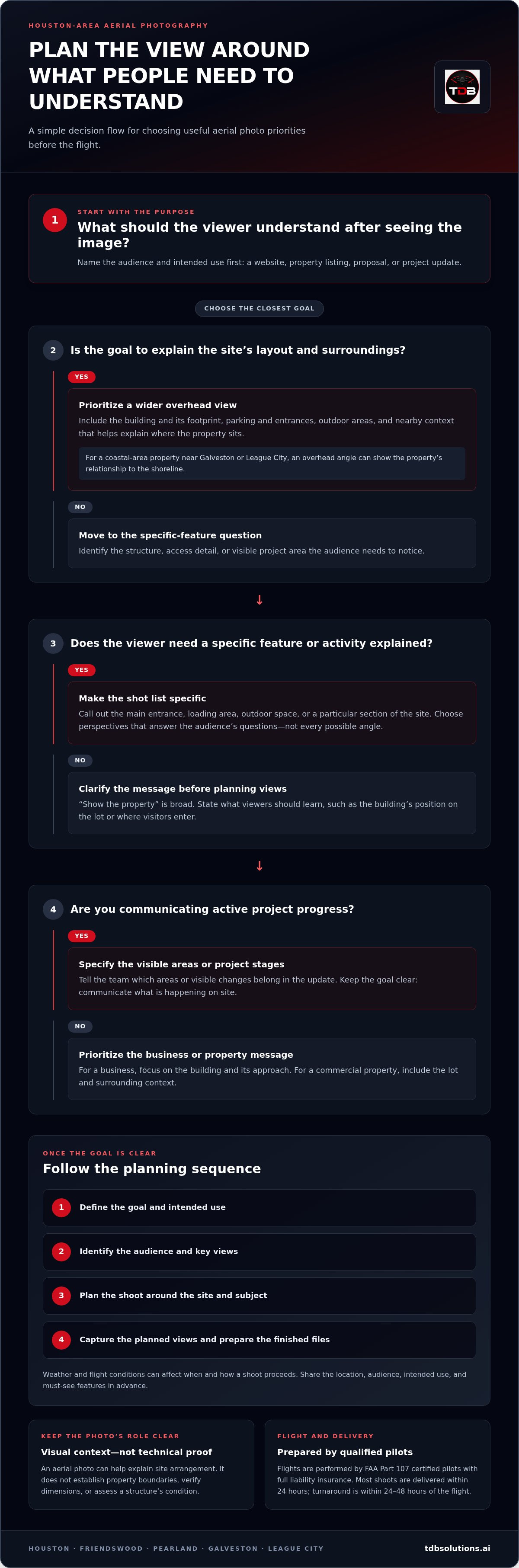
Different audiences need different information from the same site. A Houston business owner may need a clear exterior view for a website or company profile. A property team may want prospective tenants to understand the building’s layout, parking, and access. Builders can use project imagery to explain visible progress to clients or stakeholders, while marketing teams can select angles for a campaign, brochure, or presentation. Start by asking what the viewer should understand after seeing the image.
That question helps shape the shot list. If you’re promoting a business, prioritize the building and its approach. If you’re explaining a commercial property, include the lot and surrounding context. If you’re documenting active work, decide which visible areas or project stages belong in the update. For property listings, Houston real estate drone services can help communicate setting and scale alongside interior and ground-level media.
Before the shoot, name the audience and intended use, then identify the site details that support your message. A purposeful view gives viewers context instead of simply putting the camera higher.
How Houston aerial photography is planned and captured
A clear shoot starts before a drone takes off. Aerial photography turns a planned flight into photographs that help people understand a property, business, or project from above. With aerial photography services Houston businesses can get images planned around a specific audience and use, rather than a collection of attractive angles without a clear purpose.
The planning sequence is straightforward: define the goal, identify the key views, plan the shoot, capture the images, and deliver the finished files. Each step depends on the one before it. A marketing brief might call for a strong lead image that introduces a facility. A project documentation request may focus on particular areas stakeholders need to see in an update. The purpose determines which views matter.
Start with the purpose and the subject
Before scheduling, clarify who will see the images and where you plan to use them. A website, property listing, proposal, and project update may each call for a different visual emphasis. Identify the buildings, site features, or business activity viewers should notice. Share the location and priorities in advance, such as a main entrance, loading area, outdoor space, or a specific section of the site. A concise brief keeps the shoot focused.
Be specific about the message. “Show the property” is broad. “Help prospective tenants understand the building’s position on the lot and where visitors enter” gives the photographer a clear direction. For an active project, note which areas or visible changes belong in the update. This helps distinguish a polished marketing image from documentation intended to communicate what’s happening on site.
Plan the views around the site
Site layout and subject guide the camera angles. A single building may need one view to show its footprint and another to explain how it relates to parking or nearby structures. A business with several visible features may need an angle that brings them together. The goal isn’t to capture every possible view. Select perspectives that answer the audience’s questions.
Weather and flight conditions can affect when and how a shoot proceeds. The subject matters, too: a wide property and a specific building feature call for different framing priorities. TDB Solutions plans aerial photography around the site and intended images. Flights are performed by FAA Part 107 certified pilots with full liability insurance.
On shoot day, the pilot follows the agreed priorities, captures the planned views, and prepares the images for delivery. Share your audience, intended use, location, and must-see features early so the team has a practical brief to follow. To discuss a property or project, plan aerial photography with TDB Solutions.
Aerial photography, video, or technical drone documentation: what fits?
Choose the format based on what your audience needs to do with the information. A still photo gives viewers a single frame to review or reuse. Aerial video uses movement and sequence to hold attention or guide viewers through a site. Recurring construction documentation creates a visual record across project visits. Each format has a different purpose, so start with the decision the media should support.
| Format | Best fit | What it communicates |
|---|---|---|
| Still aerial photography | Property, business, or site communication | A selected view of visible features, layout, and setting |
| Aerial video | Website, advertising, or social media storytelling | Movement through a location and the relationship between visible areas |
| Recurring construction documentation | Project oversight and progress updates | How visible site conditions change across planned visits |
Photos and video communicate what appears in the frame. They don’t, on their own, establish dimensions, quantities, or design deviations. Those needs call for technical data and methods suited to measurement or analysis. If your goal is construction intelligence drone data, define the project question and the information stakeholders need to act on. This distinction helps match each deliverable to its purpose.
When do still aerial photos make sense?
Choose still images when you need a focused view that viewers can take in quickly and return to later. A property manager might use a selected frame in a presentation to orient a prospective tenant. A business owner might place an overhead image on a location page so visitors can recognize the site. Decide what one frame should communicate, then prioritize the features that support that message.
When should a project use video or progress documentation?
Video fits a story that benefits from motion. A planned sequence can guide viewers from a site’s broader setting toward a specific area, adding context that a single frame may not provide. It can support websites, advertising, and social media. For a closer look at video for business communication, see Houston marketing video production. Recurring documentation has a different purpose: it captures visible project conditions over time for updates and oversight.
Consider what the audience needs to do. A client reviewing project progress may need views gathered on a recurring schedule. A business introducing a location may prefer a short, motion-led narrative. A property team preparing a presentation may need stills that readers can scan at their own pace. If you need more than one format, plan how each will be used instead of asking one deliverable to serve every purpose.
For aerial photography services Houston businesses can match to a clear communication goal, identify whether your priority is a reusable still image, a motion-based story, or a visual record across project visits. That choice gives the shoot a sharper direction.
How to prepare a Houston property or site for an aerial photography shoot
A focused shoot starts with useful information from you. Before scheduling, identify what the audience needs to understand, which parts of the site matter most, and how you plan to use the finished media. That preparation helps shape the shot list around your property or project, whether it’s in Houston, Friendswood, Pearland, Galveston, or League City.
Use this checklist to prepare:
- Share the location. Provide the site address or location details and a point of contact for coordinating access.
- Name the priority areas. Identify the buildings, entrances, outdoor spaces, or active work areas that should take visual focus.
- Explain the surroundings. Note context viewers should see, such as access routes, neighboring site features, or waterfront proximity where relevant.
- Flag timing needs. Share a target date, project milestone, or timing consideration that should guide planning.
- State the intended use. Tell the photographer whether the images are for a website, advertising, social media, or project updates.
Prepare the location and visual priorities
Start with the site itself. A commercial property may need a view that connects the main building to parking and access. A waterfront property may call for a perspective that includes its relationship to the water. An active project may need attention on a particular area or milestone. Identify the structures and surroundings that matter before scheduling, and explain why each belongs in the frame. This context helps the photographer plan useful views rather than guess at your priorities.
Also share practical access information. If the site has a preferred entrance, a contact who can coordinate arrival, or areas that should remain outside the visual focus, include those details in your planning notes. You don’t need to map every camera angle. A short list of priorities gives the shoot a clear direction.
Give the photographer a useful creative brief
Your brief should connect the image to its audience. For a website, you might want a strong view that introduces the business or property. Advertising may call for an image that quickly communicates location and scale. Social media may benefit from a distinctive perspective, while project updates should focus on the areas stakeholders need to follow. State the intended use, then list the essential views and the message each one should carry.
Tell the photographer if the objective also includes aerial video or repeat progress documentation. Those needs affect the shoot plan and the visual coverage that will be most useful. For aerial photography services Houston clients can plan around a clear brief, focus on four points: location, priority features, audience, and intended use. Then note relevant timing or milestones. Simple preparation leads to better-aligned imagery.
Ready to plan your property or project shoot? Schedule an aerial photography shoot with TDB Solutions and share the views your audience needs to see.
Get aerial photography services in Houston from TDB Solutions
The right aerial images help your audience understand a property, business, or project. TDB Solutions provides aerial photography and media production across Greater Houston, including Houston, Friendswood, Pearland, Galveston, and League City. We plan each shoot around your goals so the views support the message you want to communicate.
What TDB Solutions brings to the shoot
Local service starts with understanding what makes your site distinct. A commercial property may need an image that explains its layout, while a business may need a clear visual introduction for its digital presence. Share the features you want viewers to notice and the context they need. That direction helps TDB Solutions plan imagery around your audience and intended use.
Our aerial photography and media production support businesses, properties, and projects across the Houston area. Use the images to give your audience a clearer sense of place, support a marketing effort, or communicate visible project activity. The goal is practical: give each view a purpose and make the finished media useful to the people who will see it.
Request aerial photography for your Houston project
Bring a clear brief to the conversation. Include the site location, why you need the imagery, who will view it, and the perspectives that matter most. If the shoot supports a campaign or project milestone, share that context too. These details help align the shoot plan with your priorities from the start.
- Location: Tell us where the property or project is.
- Purpose: Explain how you plan to use the photos or video.
- Audience: Identify who needs to understand the site.
- Visual priorities: Note the structures, features, or views you want the imagery to emphasize.
Ready to plan your shoot? Call or email TDB Solutions with your project details and the story you want the images to tell. We’ll help you turn a general idea into a focused aerial photography plan.
Turn your next project into a clear visual story
The strongest aerial imagery starts with a decision: what should your audience understand, remember, or do after seeing it? Keep that outcome at the center as you plan your next property, business, or project shoot. A focused visual brief gives each image a job, whether you’re introducing a place, supporting a campaign, or helping stakeholders follow work on site.
With aerial photography services Houston property owners and businesses can shape a view around the message they need to communicate. Think beyond the flight itself. Consider where the images will appear, who will see them, and what detail will make the scene easier to understand. That clarity gives your media a useful role after the shoot.
Ready to turn your goals into a practical shoot plan? Call or email TDB Solutions to plan your Houston aerial photography shoot. Bring your purpose and visual priorities, and take the next step toward imagery that helps your audience see the full picture.
Frequently Asked Questions
Can aerial photography show the surroundings of a Houston property?
Yes. For a useful context image, identify which nearby features help viewers orient themselves and which details could distract from the property. You can request a broad establishing view plus a tighter frame focused on the site. This gives you options for different placements without assuming every image needs to include the same amount of surrounding area. A simple marked-up map can help communicate what matters.
Is aerial photography useful for a small business location?
Yes, particularly if people have trouble recognizing the location or understanding its layout before they arrive. Consider what a first-time visitor might need to identify, such as the building’s position within the property or the general approach. Share that priority with the photographer and the team responsible for your website or campaign so the selected image fits the message and the space where it will appear.
Can aerial photography show waterfront access?
An aerial view can show how a property appears in relation to nearby water. Be precise about the feature you want viewers to see, such as the shoreline’s position within the overall setting. A photograph can show visible context, but it doesn’t establish whether access is public, private, or legally permitted. For a coastal property near Galveston, describe the intended visual context in the brief and avoid implying more than the image can demonstrate.
Do aerial photographs replace ground-level photography?
No. Decide what each viewpoint needs to contribute before planning a shoot. For example, use an overhead image to orient viewers, then use ground-level photographs for details that require a closer, eye-level view. This approach helps you avoid selecting several images that communicate the same thing. Review your existing photos first and note which information is missing, so the new images fill a clear gap in your visual materials.
Can aerial photography document construction progress over time?
Yes. To make repeat visits easier to compare, identify the areas stakeholders want to follow and keep those priorities consistent across updates. You can also connect each visit to a project milestone or reporting date, giving viewers context for the images. Aerial photographs communicate visible conditions. If your team needs other project information, define those reporting needs separately when planning the documentation.
How soon are aerial photography images delivered?
Most TDB Solutions shoots are delivered within 24 hours, with turnaround within 24-48 hours of the flight. When planning your schedule, distinguish the flight date from the date you need the images ready for review or publication. Share that deadline when arranging the shoot, especially if colleagues need time to select images or prepare campaign materials.


