

Drone inspection (aerial inspection) cuts field data collection times by up to 50% compared to manual inspection (traditional inspection) while eliminating working-at-height hazards for inspection crews. The decision in front of you is practical: when does a UAV workflow give you survey‑grade data with less downtime, and when do you still need hands-on contact? Transitioning to UAV workflows supplies highly accurate data (survey‑grade data) and reduces site downtime across commercial and industrial assets. The sections below walk that choice in order: fit, safety, cost, rules, data flow, and partner selection.
Key Takeaways: Aerial inspection cuts data collection time by 50% and eliminates working-at-height hazards, though manual methods remain necessary for tactile testing and internal repairs.
- Except when you require material tactile resistance testing or immediate physical structural repairs.
- Best for high-altitude assets like stacks and towers to replace risky scaffolding and climbs.
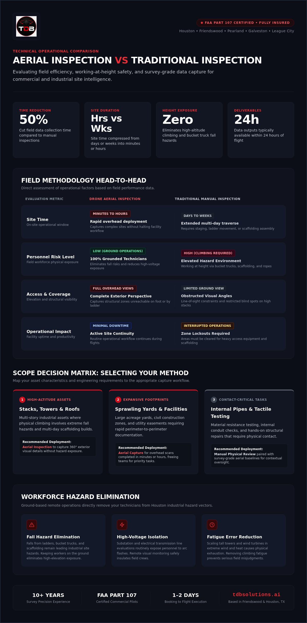
- The article's comparison table shows site time drops from weeks to hours using drones.
Match the method to height, access, and downtime goals
Selecting the right evaluation technique depends on site accessibility, asset height, and required data detail. Before you lock a scope, map the job to one of these common scenes:
- Tall stacks, towers, or multi-story roofs: use drone inspection so field teams gather full exterior views without putting workers in high-risk zones, and you cut the multi-day traverse ground crews often need.
- Sprawling yards and large facility footprints: schedule aerial capture for overhead coverage in minutes or hours, then reserve manual inspection only for spots that need close-up material sampling.
- Internal pipelines or tactile testing: keep ground-based physical review for contact work; pair it later with survey‑grade aerial baselines so you still reduce overall site downtime.
With clients we see that choosing drone inspection over manual inspection cuts operational downtime on exterior work. High-altitude asset collection scans vast layouts that ground crews take days to walk. For critical assets, collecting highly accurate data supports prompt detection of structural flaws. You can explore aerial inspection options to streamline ongoing facility checks. Local operational compliance also benefits from rapid turnarounds when the flight window is planned up front.
Ground your crew: cut fall and voltage exposure
Manual inspection exposes your workforce to extreme heights, high voltage, and hazardous environments. Falling from scaffolding or bucket trucks remains a leading cause of industrial injuries in the Houston area. You remove those direct human hazards by replacing physical climbing with remote monitoring.
During field operations, physical fatigue frequently increases error rates and serious site accidents. Deploying a drone inspection keeps your technicians safely grounded while gathering highly accurate data from complex infrastructure. To protect field crews and tighten the schedule, review inspection service paths that keep operators on the ground.
Inspectors scaling massive structures face severe falls, electrical burns, and toxic exposure. Wind turbine technicians, for example, routinely climb hundreds of feet in high winds. Remote technology pulls workers out of those positions, which lowers workplace casualties and liability claims while you hold operational uptime on hazardous industrial sites.
A commenter in the github.com thread "Welcome to TDB Solution 🌍 Your Global Engineering...":
"We believe technology should simplify complexity, not create it." (source)
Reader feedback underscores that remote monitoring should cut site dangers without complicating daily safety protocols. Removing personnel from high-risk environments lowers workplace liability and keeps the safety playbook simple for your supervisors.
Aerial vs traditional inspection: time, risk, and access
Drone inspection delivers faster field operations and safer working conditions than manual inspection. Gathering survey‑grade details from aerial views removes the need for ladders, scaffolding, or risky climbs when the goal is visual and thermal coverage.
| Metric | Aerial Inspection | Traditional Inspection |
|---|---|---|
| Site Time | Minutes or hours | Days or weeks |
| Risk Level | Low (ground operations) | High (climbing required) |
| Access | Full overhead views | Limited ground view |
Remote aircraft record structural zones you cannot reach on foot, and they do it without stopping your routine workflow. You can compare drone service Packages when you need photogrammetry, modeling, or inspection outputs for the same facility. Aerial methods fit site managers who need rapid turnarounds without putting crew members at risk. TDB Solutions helps local facility teams gather clear site insights on a schedule that matches active operations.
Flight ROI: scaffolding, labor, and downtime math
Financial return is a straight comparison: immediate operational savings versus what you spend to get the data. Replacing manual inspection with drone inspection trims scaffolding, equipment rentals, and specialized labor, so you protect margins while capturing highly accurate data across the asset footprint.
Situation → action → result: a Houston-area facility facing multi-day manual climbs (scaffolding, boom time, crew on height) moves exterior coverage to a Part 107 flight program; site time compresses from days or weeks into minutes or hours (see the comparison table), and you align spend with published market pricing instead of open-ended rental days. Market research on commercial UAV inspection pricing (about 300 samples) places typical jobs between $300 and $5,000, with a median of $769. A separate client-side read of 3 local jobs sits inside that same band. Your return still comes from labor efficiency, lower liability pressure, and less facility downtime, not from the flight fee alone.
Site accessibility dictates overall expenditure. Professional photogrammetry and inspection flights speed data collection from days to hours.
Tip: Evaluate site accessibility beforehand; avoiding heavy setup gear cuts indirect labor costs.
Part 107 and local airspace shape your flight window
FAA airspace restrictions and pilot licensing standards limit where commercial drones can fly over sensitive facilities. Regulatory compliance often sets the timeline before any aircraft launches, so flight authorizations near restricted infrastructure need administrative planning early.
Safety rules govern commercial flight paths. All flights are performed by licensed Part 107 pilots with full insurance coverage, compliant with FAA regulations for commercial drone operations. Earning a remote pilot certificate under Part 107 means meeting FAA remote pilot requirements before you fly for hire.
Local factors also affect asset work. In the Greater Houston metro area, nearby airports and industrial airspace require precise flight coordination. Choose drone inspection when you need fast exterior data under those rules; keep manual inspection when physical contact is mandatory. TDB Solutions delivers highly accurate data inside that legal frame so your project stays auditable.
Feed aerial sensor data into tools you already run
Raw visual imagery only helps after you turn it into site intelligence your team can open in existing tools. Clear data-transfer protocols prevent bottlenecks and speed reporting; direct platform integrations carry most of that load.
Raw files often choke software pipelines unless you format them for your stack up front. That single prep step keeps the project moving.
- Capture raw imagery: Drones record spatial details during drone inspection.
- Process spatial datasets: Software converts thermal and visual files into highly accurate data.
- Format file outputs: Teams export assets into formats matching your engineering tools.
- Export to software: Integrations send structured outputs straight into your project management system.
Native cloud exports fit active job sites; manual inspection workflows still lean on manual entry. The connection turns isolated imagery into shared insight for the whole team.
A commenter in the github.com thread "Welcome to TDB Solution 🌍 Your Global Engineering...":
"By combining engineering expertise with practical business thinking, we help businesses move from fragmented processes to connected, future-ready operations." (source)
Pairing structural know-how with digital tools moves fragmented site audits into a single workflow, so your Houston assets stay connected for the next maintenance cycle.
When hands-on contact still beats remote sensors
Manual inspection stays necessary when you need hands-on physical testing or immediate structural repairs on asset surfaces. Drone inspection captures visual coverage quickly, yet it cannot measure material tactile resistance or clear internal blockages. Across Greater Houston field work, physical contact still answers questions remote sensors miss, and hands-on testing supplies definitive physical proof.
Complex enclosed spaces also need direct human access. Human tactile feedback provides survey‑grade data (highly accurate data) that visual cameras cannot replicate during close-range material testing. Specialized tethered robotics continue to develop for dangerous physical testing, yet human riggers remain essential for immediate contact tasks. Use visual flights for broad aerial scanning; choose certified technicians when direct contact is mandatory.
Local Houston crews shorten response and turnaround
A certified local team means faster response times and reliable drone inspection data. Regional flight knowledge reduces costly delays when you evaluate complex assets.
Based in Houston, TX, we serve the greater Houston metro and surrounding areas including The Woodlands, Katy, Sugar Land, Pearland, Galveston, Beaumont, and beyond. That presence supports rapid deployment compared with manual inspection crews traveling in from outside the region. You get survey‑grade data tailored to site conditions, and turnarounds that keep critical operations moving.
Among TDB Solutions' Google reviews, Jason (5★) wrote:
"Always a quick response and the fastest turn-around. Top quality work. Highly recommended"
Arc in practice: you need exterior clarity on a live Houston site without multi-day scaffolding; a local Part 107 crew flies the same kind of scope Jason describes; you receive prompt, high-quality deliverables and a turnaround short enough to protect the construction or maintenance window.
Frequently asked questions
What safety risks do manual inspections pose?
Manual inspection forces field technicians to work at dangerous heights on scaffolding, swing stages, or high bucket trucks. Working on high structures creates severe fall hazards, a leading cause of industrial site injuries. Navigating hazardous industrial environments on foot also exposes personnel to structural collapse risks and dangerous chemical vapors. Replacing foot patrols with unmanned systems keeps human climbers out of that exposure path.
How do drones improve inspection safety?
Drone inspection keeps human operators on the ground while high-resolution cameras capture accurate overhead data. Remote aerial sensors reach high flare stacks, steep roofs, and high-voltage power lines without sending technicians up ladders. That approach prevents hazardous physical exposure on active job sites and holds survey‑grade visibility for your records.
What cost savings do UAV inspections provide?
Aerial surveys cut overhead by removing scaffolding assembly, heavy boom lift rentals, and long facility shutdowns. Market research places full remote flight services between $300 and $5,000, median $769; client-side review of 3 jobs falls inside that band. You reduce total inspection crew hours when exterior coverage shifts from days of setup to a planned flight window. Request a personalized quote tailored to your facility if you want a line-item comparison.
Which regulations affect drone inspections?
Federal Aviation Administration rules govern commercial flight operations in the United States national airspace system. Commercial flights are performed by licensed Part 107 pilots so operations stay aligned with FAA requirements. Complex airspace still needs active authorizations and documented safety protocols. Based in Houston, TX, we serve the greater Houston metro and surrounding areas with certified flight crews.
Can drones completely replace manual inspections?
Unmanned aircraft cannot eliminate traditional visual checks, though they capture highly accurate data that streamlines maintenance planning. High-resolution aerial imagery flags early structural defects quickly; physical repair still needs hands-on technicians. Airborne data plus targeted physical labor raises facility safety and efficiency: flights mark exact maintenance locations so your team spends less time searching on foot.
Upgrading Your Houston Asset Management in 2026
Return to the same choice you started with: use drone inspection when you need faster, safer exterior capture than manual inspection, and keep contact crews for tactile or internal work. Collecting highly accurate data helps you mitigate risk while operations stay compliant.
Transitioning exterior workflows to aerial coverage reduces field downtime and removes much of the hazardous scaffolding setup manual assessments require. FAA Part 107 licensed pilots deliver rapid turnarounds tailored to industrial facilities across the Greater Houston area, giving you a visual timeline rather than scattered snapshots.
Reach out to the TDB Solutions team to evaluate your assets and request a customized deployment estimate at tdbsolutions.ai/contact.


