

If you need a DroneDeploy alternative for Houston general contractors, the real decision is how you control multi-year software overhead while still getting usable site data. Market research on top providers places annual construction-drone subscriptions between $287 and $4,000, so the platform you pick (or the managed service you substitute) directly shapes cost for 3D documentation, high-accuracy aerial maps (orthomosaic), and volume calculation workflows.
Key Takeaways: Houston general contractors can replace DroneDeploy with specialized volumetric platforms or managed services to control annual software costs ranging from $287 to $4,000.
- Annual subscription fees for construction drone platforms typically span between $287 and $4,000.
- Except when running heavy civil projects, where generic mapping tools lack necessary earthwork accuracy.
- Choose managed drone services to eliminate recurring software seats and hidden data storage fees.
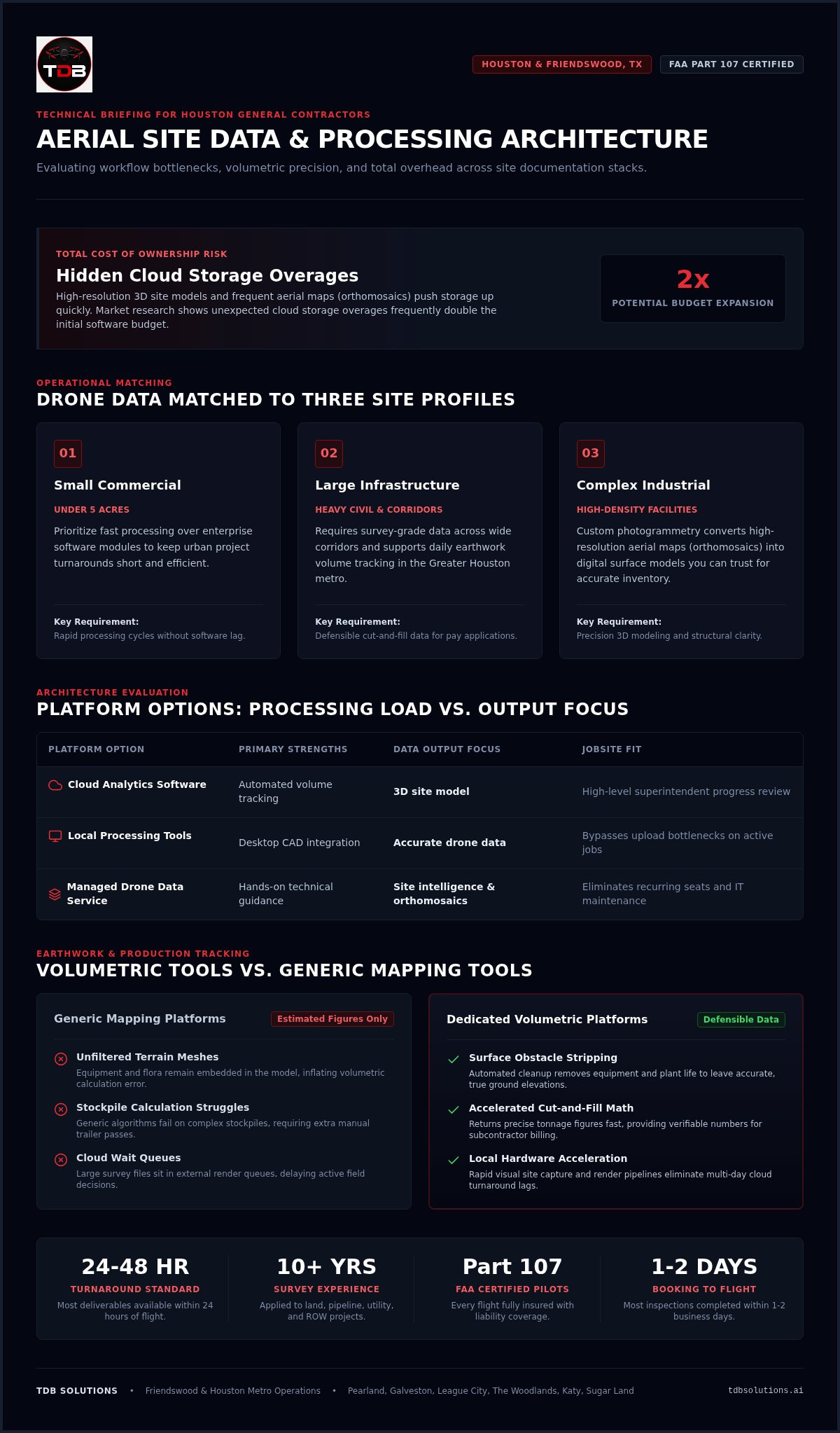
- Market research shows unexpected cloud storage overages frequently double the initial software budget.
Match drone software to three site profiles and stop overpaying
You choose software for the site you actually run, not for a brochure feature list. Three profiles show up again and again with Houston crews:
- Small commercial builds under five acres: prioritize fast processing over enterprise modules so urban turnarounds stay short.
- Large infrastructure / heavy civil: use advanced tools that produce accurate drone data (survey‑grade data) across wide corridors and support daily earthwork volume tracking in the Greater Houston metro.
- Complex industrial facilities: lean on custom photogrammetry so high-resolution aerial maps support inventory you can trust.
Matching features to that profile cuts idle compute and keeps field decisions timely. Explore how photogrammetry and 3D modeling convert raw site photos into an interactive 3D site model (digital surface models) when you want the capture-to-model path handled for you.
Construction platforms compared by processing load and output
General contractors need alternatives that process aerial maps efficiently for active jobsite tracking. How much processing your team can run internally usually decides the shortlist.
Client engagements show the same pattern: execution speed and integration requirements matter more than brand labels. Site teams stall when raw survey files demand heavy local computer power; dedicated processing platforms remove that bottleneck so large files move instead of sitting in a queue.
| Platform Option | Primary Strengths | Data Output Focus |
|---|---|---|
| Cloud Analytics Software | Automated volume tracking | 3D site model |
| Local Processing Tools | Desktop CAD integration | Accurate drone data |
If you want fast site turnaround without owning the software stack, review scope and fit on the about the team page for Houston projects. Expert crews help you shift into modern mapping workflows without a long internal IT project.
A commenter in the github.com thread "Welcome to TDB Solution 🌍 Your Global Engineering...":
"At TDB Solution, we believe businesses need more than a software vendor, they need a trusted engineering partner capable of supporting the entire transformation journey." (source)
That line matches what contractors gain when they move past a bare subscription and add hands-on technical guidance during the changeover.
Earthwork and production tracking: volumetric tools beat generic maps
Dedicated volumetric platforms deliver higher accuracy for heavy civil work than general-purpose mapping tools. Standard software often struggles with complex stockpiles; earthwork-focused platforms finish cut-and-fill calculations faster and cut volumetric error across the job.
Unfiltered terrain meshes inflate error when equipment and flora stay in the model: you need processing that strips those obstacles so true ground elevations remain. Accurate drone data depends on that cleanup, not on another manual pass in the trailer.
Generic tools give quick estimates; civil-specific platforms return tonnage numbers you can defend in pay apps. If you need precise 3D site model outputs, volumetric tools fit earthmovers; basic aerial maps software is enough for many general superintendents. Align software and local ground control through the contact form when you want that checked against your control network.
Fast 3D documentation without multi-day cloud waits
Open-source photogrammetry paired with specialized local processing still yields the shortest turnarounds for complex site mapping.
Field experience shows local cloud render pipelines finish visual site captures faster than generic off-the-shelf stacks, and native hardware acceleration reduces upload bottlenecks on active jobs. For high-impact stakeholder updates, aerial marketing videos add quick visual site capture, clear aerial maps, and progress reports without multi-day waits on someone else’s render queue. A dependable 3D site model still needs accurate drone data up front so you do not pay for rework later. More on this: Aerial Marketing Videos.
Local processing fits Houston general contractors who run tight deadlines and cannot pause crews for software lag.
5-Year total cost of ownership and where fees hide
Before you sign a multi-year contract, map tier structures and processing limits against the data volume you will actually upload.
Situation: Greater Houston client work shows high-resolution 3D site models and frequent aerial maps (orthomosaics) push storage up fast. What breaks: unexpected cloud storage overages. Result: those overages frequently double the initial software budget.
Market research on top providers places annual enterprise licenses between $287 and $4,000. A separate set of three client cost reviews locally shows the swing often comes from overages and export tiers, not from the sticker seat price alone. Fixed project caps beat open-ended data-volume pricing when you need Houston operations to scale on a predictable line item.
Hidden fees sit in advanced processing tiers: basic plans may cover standard site mapping, yet exporting survey‑grade data (accurate drone data) or CAD-compatible files often forces an upgrade. Treat licensing diligence the way you would treat a crane rental surcharge check: read the add-ons before the outage hits your margin. Ask vendors for custom quotes tied to your active jobsite volumes.
Tip: Analyze annual processing expansion caps before committing to a tier, as unexpected dataset overages scale costs exponentially.
When in-house platform seats drain your construction budget
In-house software seats drain construction capital through recurring user fees, specialized staff, maintenance, and training. Hiring a professional local drone company removes that stack in one move.
Across Greater Houston site visits, aerial maps from dedicated crews stop software creep: you still receive accurate drone data without year-round enterprise seats. Idle licenses keep billing through permitting delays even when no one flies; that pattern alone pushes lean field teams toward outsourced capture.
Ask for a tailored service quote when you want numbers against your seat count and flight frequency.
4 Steps to onboard local managed drone data
You can stand up local managed drone data through a four-step path that keeps flight ops off your PM’s plate.
Project managers save hours when a local crew owns flight operations instead of internal software setup and flight-plan configuration.
- Schedule site capture: Request flight coverage for your location in the greater Houston metro and surrounding areas.
- Execute compliant flights: FAA Part 107 certified pilots fly the missions so commercial operations stay inside federal rules.
- Process site data: Flight imagery becomes accurate drone data and a 3D site model.
- Deploy aerial maps: Download final aerial maps straight into the project tools you already use.
Based in Friendswood and working Houston, TX jobs, this pipeline delivers processed site assets to your desk without a desktop photogrammetry science project. Local dispatch keeps turnarounds short on active jobsites.
Among Google reviews, a client’s specialist (5★) wrote:
"Dillon is great! From start to finish-VERY detailed and thorough throughout the whole process. Awesome drone skills. Will definitely be using for all my media and marketing needs!"
Detailed execution from certified pilots is what keeps imagery usable without adding delay to the ground schedule.
A commenter in the github.com thread "Welcome to TDB Solution 🌍 Your Global Engineering...":
"We have partnered with clients and organizations across Vietnam, Canada, the United States, and France, supporting projects in manufacturing, engineering, and digital transformation." (source)
Frequently asked questions
What drone software fits construction work?
Pick from immediate operational needs, field constraints, and project scope. Many Houston general contractors run routine tasks on cloud platforms; heavier data demands call for specialized tools. Aerial maps still need consistent precision at each phase of site development.
Which option fits survey and engineering teams?
Survey and engineering teams need platforms centered on accurate drone data and direct hooks into civil design workflows. Local presence in Houston, TX, with service across the greater metro, supports rapid dispatch when your jobsite cannot wait on a distant vendor queue.
Which option fits earthwork and production tracking?
Tools built for volume calculation and cut-fill analysis track earthwork cleanly and surface site change fast enough to protect the schedule. Across the broader market, software prices span $287 to $4,000 based on a sample of top software providers; your number still moves with features, site size, and reporting frequency.
Which option fits fast 3D documentation?
When you need rapid site records, photogrammetry that finishes quickly lets you review a 3D site model in hours rather than days. Pair that speed with Part 107-compliant flight ops so documentation does not slow the crews already on the ground.
What alternative fits survey-heavy work?
Survey-heavy projects need strict regulatory compliance and crews who already know regional terrain. Coverage across the greater Houston metro (The Woodlands, Katy, Sugar Land, Pearland, Galveston, and Beaumont) keeps collection and deliverables aligned to local commercial jobsites.
Choosing your DroneDeploy alternative for Houston general contractors
The through-line is unchanged from the open: judge platforms against your 3–5 year budget, your site profile, and whether you want to own processing or hand it to a local crew, so 2026 does not arrive with storage surprises and rework.
Inaccurate site measurements compound into project overruns; the right mix of tool and capture method protects margin on long builds.
TDB Solutions provides turnkey drone data collection and managed project modeling across the Greater Houston metro. FAA Part 107 licensed pilots gather accurate drone data for your 3D site model and aerial maps, with local provenance aimed at fast turnarounds on each site.
Reach the team on the contact page when you want a custom project quote.


