

What can a view from above tell a prospective buyer or tenant that ground-level photos miss? Commercial real estate aerial photography can show a property’s layout, parking, access points, neighboring businesses, and surrounding area in one clear frame. But a dramatic angle alone isn’t enough. The image should help people understand the site and answer questions that matter to them.
Buyers and tenants need more than attractive pictures. They need useful context. This guide explains what aerial photography can reveal, which views may answer common property questions, and how to plan images around your marketing goals.
You’ll also learn what to ask a Houston-area provider about flight planning, photo and video options, pilot credentials, insurance, and delivery timing. Aerial marketing images aren’t the same as an aerial inspection or surveying service, so it’s important to request the right work for your goal. TDB Solutions provides real estate media in the Houston area, captured by FAA Part 107 certified pilots with liability insurance. Most shoots are delivered within 24 hours, but confirm the schedule for your specific project.
Key Takeaways
- Use commercial real estate aerial photography to help viewers understand a site’s layout, access points, parking, and nearby context.
- Pair aerial and ground-level images so your marketing materials show both the overall setting and on-site details.
- Choose a service based on your goal: marketing images, a visual aerial inspection, or mapping each serve different purposes.
- Plan the shoot around your audience and identify priority views, access routes, parking areas, and surroundings.
- Before booking a Houston-area provider, ask about relevant experience, pilot credentials, insurance, sample work, deliverables, and timing.
What Commercial Real Estate Aerial Photography Shows About a Property
Commercial real estate aerial photography captures property-focused images from an airborne platform, often a drone. It gives owners, brokers, and prospective tenants a wider view than ground-level photos can provide. A well-planned image can show how a building sits within its lot, where parking areas connect to driveways, and how landscaping shapes the site.
The broader practice of Aerial photography includes different platforms and uses. For commercial property marketing, the goal is to make a site easier to understand at a glance. Choose a viewpoint for the property and its audience, rather than simply asking for the highest or most dramatic angle.
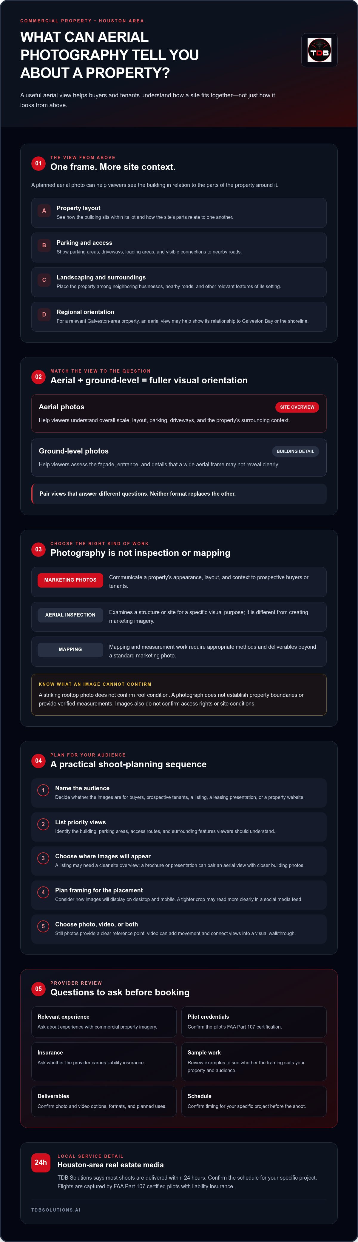
Keep the purpose clear. Marketing photos communicate appearance and context. An aerial inspection examines a structure or site for a specific visual purpose, while mapping and measurement work require appropriate methods and deliverables. A striking rooftop image doesn’t confirm a roof’s condition. A photograph also doesn’t establish property boundaries or provide verified measurements.
Which property details are easier to understand from above?
A wide view can show a building in relation to its parking, driveways, loading areas, and landscaping. It helps viewers see how the parts of the site fit together before visiting. Surrounding context may matter, too. Nearby roads, neighboring commercial uses, or waterfront access can help explain a property’s setting. For a property near the Galveston waterfront, for example, an aerial view may show its relationship to the shoreline. It doesn’t verify access rights, boundaries, or site conditions.
Who uses commercial property aerial photos?
Owners can use aerial photos to introduce a property’s layout. Brokers can add an overview to listing and leasing materials, while property managers can use images on a business website to help prospective tenants orient themselves. Tenants can review the visible arrangement, then confirm property details directly with the representative. Pair aerial views with ground-level photos so viewers can see both the full site and closer building details.
Before a shoot, identify the audience and where you plan to use the images. A listing may need a clear view of the building and parking, while a leasing presentation may benefit from more surrounding context. For guidance on comparing providers and services, read the Houston real estate drone services buyer’s guide.
How Aerial Photos Add Context to Commercial Property Marketing
A property presentation works best when each image answers a different question. Ground-level photos help viewers assess the building itself. Aerial photos show how the site fits together and where it sits in the surrounding area. Used together, they give prospective tenants or buyers a clearer visual orientation without implying a guaranteed leasing or sales result.
Aerial views versus ground-level property photos
Commercial real estate aerial photography can establish a site’s overall scale and show how buildings relate to driveways, parking, and nearby roads. A ground-level view can communicate façade materials, the appearance of an entrance, and details a wide aerial frame may not reveal clearly. Neither format replaces the other. Choose images based on the questions your audience is likely to ask, then pair views that offer distinct information.
For a Houston-area property, an aerial frame might show how the site connects to a nearby road. For a Galveston-area property, it may help place the site in relation to Galveston Bay, if that context is relevant. Keep the composition focused on useful orientation. Don’t imply that an image confirms access rights, boundaries, or property conditions.
Where aerial imagery can appear in a marketing plan
Decide how you’ll use the images before the shoot. A property listing may need a wide view that quickly establishes the site layout. A brochure or presentation may have room for a labeled aerial view alongside closer building photos. On a website, consider how the image will display on desktop and mobile screens. For social media, a tighter crop may read more clearly in a small feed. Ask for framing and orientation suited to the placements you plan to use.
Still photos can provide a clear reference point. Video can add movement and connect views into a visual walkthrough. Decide which format suits each part of your marketing material rather than expecting one asset to do every job. For ideas on combining moving images with business marketing, read TDB Solutions’ Houston marketing video production guide.
If you’re planning a commercial shoot, ask who will fly and what photography or video deliverables the provider will supply. The FAA explains commercial drone operations through its FAA-Certified Drone Pilot resource. To discuss real estate media for your Houston-area property, visit TDB Solutions’ real estate media services.
Aerial Photography, Drone Inspection, and Mapping: Which Does Your Property Need?
Start with the question you need the drone work to answer. Do you need marketing images that help people understand a property, a visual review of a structure, or mapped information for measurement and analysis? These are different goals with different deliverables. Aerial photography alone doesn’t provide an inspection finding or establish a property’s measured area or boundaries.
| Service | Primary purpose | What to clarify |
|---|---|---|
| Marketing photography | Present the property’s appearance, layout, and surroundings to prospective buyers or tenants. | Which views, photo or video formats, and intended uses are included? |
| Aerial inspection | Examine a structure or site visually to address a specific condition-related question. | What areas will the provider examine, and what findings or documentation will you receive? |
| Mapping | Create mapped outputs for a defined spatial or measurement purpose. | What output, accuracy, and measurement scope does your project require? |
A polished image can make a roof look clear and orderly, but it doesn’t prove that the roof or structure is sound. A photograph records a visible scene from a particular viewpoint. It isn’t a condition assessment. Likewise, a compelling overhead image doesn’t establish measured areas, property boundaries, or survey accuracy. If you need those answers, confirm that the provider offers the specific technical service and deliverable you require.
When commercial property aerial photography is the right fit
Choose commercial real estate aerial photography when your goal is to communicate a property’s layout, setting, or visual appeal. An owner preparing leasing materials, for example, may want viewers to see how a building relates to parking and access areas. A broker may prioritize surrounding roads or nearby uses. Base the shot list on the audience and marketing placement, and describe only what the images visibly show.
When to ask about inspection or mapping instead
If you need someone to assess a roof’s condition or answer a measurement question, say so before booking. Ask what the work covers, how the provider will document findings, and whether the deliverable answers your technical question. Don’t assume a photography package includes inspection or mapping. These are distinct scopes, and discussing them up front helps you choose a provider for the work you need.
How to Plan a Commercial Property Aerial Photography Shoot
A useful shoot starts with a clear brief, not a request for “some drone shots.” Decide what a prospective buyer, tenant, or business visitor should understand after seeing the images. Then share that goal with the provider so the flight plan and deliverables support the property’s marketing use.
Build a property-specific shot list
Commercial real estate aerial photography should answer specific questions about the site. Work with the property contact to identify the visible areas that matter to your audience, then prioritize views such as:
- Overall site view: Show the building in relation to parking, landscaping, and other visible site features.
- Access routes: Include driveways or nearby roads if they help viewers understand how the property connects to its surroundings.
- Property-specific context: Note relevant neighboring uses, waterfront setting, or other visible features that support the property’s presentation.
- Marketing-focused angles: Identify views for the listing, leasing materials, presentation, or website where you plan to use them.
Keep the list focused. Each view should answer a property question or serve a defined marketing purpose. Skip angles that don’t add useful context. Describe visible features accurately, since photos don’t verify boundaries, access rights, or property conditions.
Prepare the site and align expectations
Before the shoot, coordinate with the property contact about site access and any operational considerations that could affect the planned views. Confirm the date and timing, the photo or video deliverables, how you’ll receive them, and the expected delivery schedule for your project. Ask how the provider handles weather or scheduling changes. Flight conditions can affect plans, so don’t assume a particular date is guaranteed.
Tell the provider where you intend to use the images. A wide view for a property listing may call for a different composition from an image intended for a mobile website or brochure. Clear use cases help you agree on framing before the flight.
If your property is in Houston, Friendswood, Pearland, Galveston, or League City, confirm service availability for your location and project. TDB Solutions provides Houston-area real estate media, with aerial photos and video captured by FAA Part 107 certified pilots with liability insurance. For a shoot-specific plan, contact TDB Solutions about commercial property aerial photography.
Choosing a Houston-Area Commercial Real Estate Aerial Photography Provider
The right provider should understand both the image you need and its purpose. For commercial real estate aerial photography, look for relevant property experience, clear communication, and a specific description of the photos or video you’ll receive. Review sample work for more than visual polish. Check whether it shows the kind of property context your audience needs to see.
Questions to ask before booking aerial photography
Use this checklist to compare providers and clarify the scope before scheduling:
- Experience: Can the provider share examples of aerial photos for commercial properties, not just general drone images?
- Credentials and insurance: Who will pilot the drone? Ask whether the pilot holds FAA Part 107 certification and whether the planned shoot has appropriate liability insurance.
- Views and formats: Which angles will the provider capture? Confirm whether your deliverables include photos, video, or both, and ask whether they suit your intended uses.
- Access and communication: Who coordinates access with the property contact? Ask how the provider will communicate schedule changes or weather-related adjustments.
- Delivery: What will you receive, how will it be delivered, and what schedule should you expect for this specific shoot?
Ask for a clear description of deliverables before booking. Terms such as “aerial package” can mean different things to different providers. Confirm the number and type of deliverables included, the planned views, and any details about how you can use the finished media. TDB Solutions reports that most shoots are delivered within 24 hours, but confirm the timing for your project.
Turn a property brief into a clear next step
A focused inquiry helps the provider assess your needs. Include the property’s location, whether you’re marketing it for sale or lease, who you want to reach, and where you plan to use the imagery. List priority views, such as the full site, building, parking, or nearby context. Include any access details the property contact can confirm.
TDB Solutions is based in Houston and serves surrounding communities, including Friendswood, Pearland, Galveston, and League City. Its FAA Part 107 certified pilots capture aerial photos and video for real estate media, with liability insurance. Share your goals and ask which views and deliverables fit your property’s marketing needs. Contact TDB Solutions to discuss a property shoot.
Plan Aerial Images Around Your Property’s Goals
Strong commercial real estate aerial photography answers real questions about a property. It gives viewers a clearer sense of the site’s layout and surroundings, while ground-level photos capture building details and entrances. The right shot list depends on your audience and where you’ll use the images.
Before booking, be clear about the purpose. Marketing photos communicate appearance and context; inspection and mapping services address different technical needs. Confirm the views, formats, access arrangements, and delivery schedule with your provider so expectations are clear before the shoot.
For Houston-area real estate media, TDB Solutions uses FAA Part 107 certified pilots with liability insurance. Founder Dillon Bates brings over 10 years of survey experience, informing a careful approach to property visuals without confusing marketing images with survey deliverables.
Ready to plan images for a commercial property in Houston, Friendswood, Pearland, Galveston, or League City? Discuss aerial photography for your commercial property. Start with your goals and audience, then build a shot list that gives viewers useful context.
Frequently Asked Questions
What is commercial real estate aerial photography?
Commercial real estate aerial photography uses images captured from an airborne platform to show a commercial property from above. Depending on your brief, the photos can show a building’s position, site layout, access routes, landscaping, and nearby context. It’s a visual marketing tool, not a technical assessment. Aerial photos alone don’t establish property boundaries, measured areas, survey accuracy, or a building’s condition.
What can aerial photos show about a commercial property?
Aerial photos can help you see how buildings relate to parking, access routes, landscaping, and surrounding land uses. They may also provide wider context, such as nearby roads or a waterfront setting. What viewers can see depends on the property’s layout, selected viewpoints, and shoot brief. Treat the images as visual context, not verified measurements or condition reports.
Are drone photos enough to assess a commercial roof?
No. Aerial photography may show visible roof areas from selected viewpoints, but marketing images don’t establish a roof’s condition or replace a formal inspection. If you need a condition assessment, explain the questions you need answered before booking. Confirm that the provider offers the appropriate inspection service, what areas it covers, and what findings or documentation you’ll receive. Keep marketing photography and technical assessment as separate scopes.
How do aerial photos differ from ground-level commercial property photos?
Aerial photos give you a higher viewpoint for understanding a property’s layout and surroundings. Ground-level photos reveal details such as façades, entrances, and building features that may be harder to see from above. Each format answers different questions. For a listing, leasing package, or business website, choose images based on what prospective buyers, tenants, or other viewers need to understand. Combine formats when they add distinct context.
Do I need an FAA Part 107 certified pilot for commercial drone photography?
Ask the provider to confirm the pilot’s credentials and insurance for your planned shoot. TDB Solutions says its flights use FAA Part 107 certified pilots and that it carries liability insurance. Before booking in Houston, Friendswood, Pearland, Galveston, or League City, discuss the property location, access, planned work, and relevant coverage directly. Don’t assume a credential alone confirms that every service or project requirement is covered.
How soon can I receive commercial real estate aerial photos?
Delivery depends on the shoot, agreed deliverables, and schedule, so confirm timing for your property before setting listing or campaign deadlines. TDB Solutions reports that most shoots are delivered within 24 hours. Its supplied service information also cites a 24-48-hour turnaround after the flight. Ask which timeline applies to your project and when the delivery period begins.


