

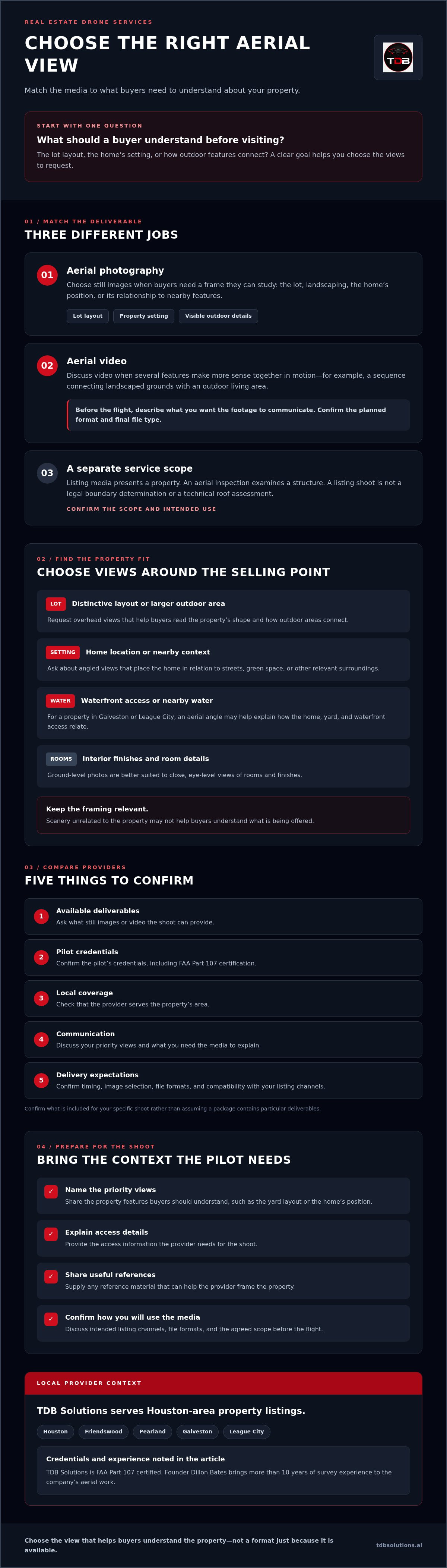
The right aerial view can make a property’s setting clear before a buyer ever visits. But not every listing needs the same real estate drone services. You may want still photos to show the lot and landscaping, video to connect a home with its surroundings, or a separate aerial inspection to examine a structure.
To choose well, start with what buyers need to understand, then compare the provider’s available media, credentials, service area, and delivery expectations. This guide explains how to match a shoot to your property, what to ask before booking, and how to prepare for a useful result.
For listings in Houston, Friendswood, Pearland, Galveston, and League City, aerial views may show waterfront access, lot layout, or neighborhood context that ground-level images do not. TDB Solutions is a Houston-based drone service provider with FAA Part 107 certification. Founder Dillon Bates brings more than 10 years of survey experience to the company’s aerial work. Use the checklist below to decide what to request and how to keep your shoot aligned with your listing plans.
Key Takeaways
- Choose aerial photos or video based on the property features buyers need to understand.
- Use still images to show the lot and setting, and ask about video when connected features are easier to communicate in motion.
- Compare real estate drone services by available deliverables, pilot credentials, local coverage, communication, and delivery expectations.
- Prepare by sharing priority views, access details, and any reference material that helps the provider frame the property.
- Confirm the shoot’s scope and intended use. Listing media is not a legal boundary determination or a technical roof assessment.
What Real Estate Drone Services Add to a Houston-Area Listing
Real estate drone services provide property-focused aerial media, such as photography and video, to help buyers understand a listing’s layout and setting. This is marketing media. An aerial inspection examines a structure, while land surveying addresses measurement and boundaries. A listing shoot should not be presented as either of those services.
From above, buyers can see how a home, yard, driveway, and outdoor features relate to one another. Ground-level photos are better suited to room details and eye-level views. Aerial media adds context that can be difficult to convey from the street. For a general overview of the format and its uses, see Aerial photography.
Which property details are easier to understand from above?
An overhead view can make a property’s layout easier to read, especially when outdoor features are spread across a larger lot. Buyers can see the home’s position, landscaping, and how outdoor areas connect. For a waterfront property in Galveston or League City, an aerial angle may help show the relationship between the home, yard, and waterfront access. The most useful view depends on the features the property actually has.
Aerial views can also place a home in its immediate surroundings, such as near streets or green space. Keep the framing focused on context that helps buyers understand the listing. A view dominated by scenery unrelated to the property may not help explain what is being offered.
Is aerial photography right for every listing?
Not necessarily. Consider the property’s size, setting, and selling points. A home with a distinctive lot layout, extensive landscaping, waterfront access, or a large outdoor area may benefit from an overhead perspective. If the main features are interior finishes and room details, ground-level photography may do more to present them.
The formats have different jobs. Ground-level photos show rooms and finishes up close. Aerial photography gives buyers a wider view of the lot and its setting. Video can connect multiple views into a moving presentation, depending on the deliverables you arrange with the provider.
Before booking, identify what you want a buyer to understand. Is it the yard’s layout, the home’s position within the neighborhood, or how the property relates to the water? A specific goal helps you decide whether aerial media will add useful context and which views to request. Good listing media supports the presentation, but it does not promise a faster sale or a higher offer.
Which Real Estate Drone Deliverables Fit Your Property?
Choose deliverables based on the information buyers need, not the number of formats a provider can offer. Still images give viewers a frame to study. Video connects views in motion. The right mix depends on the property’s strongest features and where you plan to use the media. Ask the provider to confirm available deliverables, file formats, and expected timing for your shoot rather than assuming a package includes specific items.
When should you request aerial photography?
Aerial photography can help communicate a property’s location, lot layout, and relationship to nearby features. An overhead still can clarify the shape of an outdoor area, while an angled view can show the home in context. High-resolution photos can also help viewers examine visible details more closely.
Before booking, ask how many images are included, how the files will be delivered, and whether they suit your intended listing channels. If you’re coordinating a real estate shoot, the National Association of REALTORS® drone guidelines offer industry guidance on drone use for real estate professionals.
When does aerial video suit a property listing?
Moving footage can connect a home’s exterior, yard, and surroundings in a single sequence. It may be useful when several features make more sense together, such as landscaped grounds leading to an outdoor living area. Before the flight, tell the provider what you want the footage to communicate. Confirm the planned format and final file type as well.
Use this quick guide to shape your request:
- Lot layout or location: Ask about still aerial views that orient buyers to the property.
- Visible outdoor details: Ask whether high-resolution photos can show those features clearly.
- Several connected features: Discuss whether video can link them into a clear visual sequence.
- Listing use: Confirm image selection, file formats, and compatibility with your intended channels.
These are questions to discuss, not guaranteed package inclusions. For broader business video needs beyond a property listing, see Houston marketing video production. To discuss property-focused media, review TDB Solutions’ real estate media and ask which deliverables suit your listing.
How to Compare Real Estate Drone Services in Greater Houston
Compare providers on more than sample images. Check that the available deliverables match your listing, ask who will conduct the flight, and confirm local coverage and delivery expectations. These questions can help you assess fit before scheduling a shoot in Houston, Friendswood, Pearland, Galveston, or League City.
| What to compare | What to ask |
|---|---|
| Deliverable fit | Which photo or video formats are available for my listing goals? |
| Pilot credentials | Is the person conducting my flight FAA Part 107 certified? |
| Service area | Do you serve this property’s city and location? |
| Communication | Who should I contact about access, shoot details, or changes? |
| Delivery expectations | When does the delivery timeline begin, and when should I expect the media? |
What credentials and coverage should you ask about?
Ask whether the person who will conduct your flight holds FAA Part 107 certification. The National Association of REALTORS® drone guidance offers additional context for real estate professionals considering drone use. Credentials are important to check, but they do not guarantee a particular composition or image result. Review relevant work and explain the views you need.
Confirm the service area before booking. A provider may cover Houston and nearby communities but not every property or shoot request. Share the listing address and ask directly whether the location is covered. Discuss access coordination and any location-specific considerations before setting a shoot date.
How can you compare turnaround and service fit?
Ask when the delivery timeline starts, whether it begins after the flight, and what could affect the expected timing. Compare the answer with your listing deadline, and leave room for changes if your schedule is tight. Get the deliverables and timing expectations clear before you commit to a publication date.
Keep the purpose of the work clear. Aerial marketing media presents a property to buyers. It is not a technical assessment of a roof or other structure. If you need an assessment of roof condition rather than listing media, read about drone roof inspection in Houston and confirm which service fits your need.
Once you’ve compared credentials, coverage, deliverables, and timing, explore TDB Solutions’ real estate media as one local option for your listing.
How to Prepare a Houston-Area Property for a Drone Shoot
A focused shoot starts with a clear brief. Set the listing goal, identify the features buyers should notice, coordinate access, and confirm the deliverables with your provider. This gives the provider a useful starting point for planning views instead of having to guess what matters to you.
What should you share before the shoot?
Share the property location, access instructions, your media deadline, and a short list of priority features. For example, you may want to emphasize a landscaped yard, the home’s position on the lot, or waterfront access. If you have a site plan or marked property boundaries, you can share it as a visual reference for framing. Aerial marketing media does not verify legal boundaries.
Confirm the deliverables before setting expectations with your agent or listing team. Ask which photo or video formats the provider can supply, how the files will be delivered, and whether they suit your intended listing channels. Put your preferred views in writing so you and the provider have the same plan.
- Define the goal: State what buyers should understand from the aerial media.
- Identify key features: Note the lot layout, landscaping, outdoor areas, or waterfront access to prioritize.
- Coordinate access: Provide the address, entry instructions, and a point of contact.
- Confirm deliverables: Agree on available formats and your expected media deadline.
Keep the purpose specific. Real estate media presents a property to prospective buyers. It differs from construction documentation, which tracks site activity and project progress. If you need that type of coverage instead, see drone progress documentation for construction sites.
What should you confirm on shoot day?
Before the scheduled flight, confirm access and who will meet or assist the provider at the property. Review the priority views together, particularly if conditions on site have changed since booking. Ask whether the provider anticipates any flight limitations at that location and how weather or other scheduling changes will be communicated. These questions help you plan for changes without assuming a specific flight or delivery schedule.
For real estate drone services in Houston, Friendswood, Pearland, Galveston, or League City, clear priorities and timely coordination can help keep the shoot aligned with your listing needs. Contact TDB Solutions about real estate media to discuss available deliverables, access, and timing for your property.
Choosing Real Estate Drone Services from a Local Houston-Area Provider
A local provider can help you plan aerial media around the property, its setting, and your listing goals. TDB Solutions provides real estate media in the Houston area, including Friendswood, Pearland, Galveston, and League City. The aim is to capture views that help buyers understand the property’s layout and surroundings, not to promise a particular sale result.
What does TDB Solutions bring to a property shoot?
TDB Solutions is an FAA Part 107 certified drone service provider. Founder Dillon Bates brings more than 10 years of survey experience to the company’s aerial work, with an understanding of technical detail and site context. Property marketing images can show visible features and surroundings, but they do not establish legal property boundaries or replace a formal boundary determination.
For a home with a large yard, landscaping, or waterfront access, aerial views can show how features relate to one another and to the surrounding area. The useful perspective depends on your listing. Share the features you want buyers to notice, then ask which still-photo or video formats are available for your shoot. Confirm the scope rather than assuming a package includes a particular number or type of files.
Timing matters too. Tell the provider your listing deadline and ask when to expect the media, including when the delivery timeline begins. Get the expected timing for your specific shoot before planning the rest of your listing schedule around it.
What are the next steps to request real estate drone services?
Start with the details that help the team assess fit and plan the shoot. Share the property location, what you want buyers to understand, your priority aerial views, and when you need the media. Include access instructions and any reference material that helps identify the areas you want covered.
Then confirm the service area, available media formats, shoot details, and expected delivery timing directly with the team. Clear answers make it easier to plan the listing and understand what the shoot includes. If your property is in Houston or a nearby community, contact TDB Solutions to discuss your property shoot.
Choose Aerial Media That Fits Your Listing
The right real estate drone services match your property and listing goals. Choose aerial photography for still views of the lot and setting, or ask about video when moving footage could connect key features. Before scheduling, confirm the deliverables, pilot credentials, service area, and expected timing.
TDB Solutions serves Houston and nearby communities, including Friendswood, Pearland, Galveston, and League City. The company is an FAA Part 107 certified drone service provider, and founder Dillon Bates brings more than 10 years of survey experience to its aerial work. Share your property location, the views you want buyers to see, and your listing deadline. Confirm available media formats and shoot details with the team so the aerial presentation fits your property.
Frequently Asked Questions
What do real estate drone services include?
Real estate drone services provide aerial media to help buyers understand a property’s layout and setting. Depending on the provider and agreed scope, the work may include aerial photography or video. Ask which formats are available, how the provider will deliver them, and whether they fit your listing channels. Don’t assume every provider offers the same media. Confirm the deliverables and shoot details before booking.
Are drone photos worth it for a real estate listing?
Aerial photography can help buyers see features that ground-level images may not show as clearly, such as lot layout, landscaping, waterfront access, and neighborhood context. Whether it is useful depends on the property and the story you want to tell. Ask what an overhead view would help a buyer understand. If it adds meaningful context, discuss suitable views and formats with the provider.
How do I choose a real estate drone service?
Compare available media, pilot credentials, service area, communication, and stated delivery expectations. Ask how the planned views will show the features that matter to your listing, then confirm the deliverables before scheduling. For a property in Houston, Friendswood, Pearland, Galveston, or League City, verify coverage for its specific location. Clear answers about the shoot, access, and delivery help you decide whether the service fits.
Are real estate drone pilots required to be FAA Part 107 certified?
Requirements depend on the operation, so verify current FAA guidance for your situation. TDB Solutions is an FAA Part 107 certified drone service provider. When comparing providers, ask who will conduct your flight and whether that person holds the relevant certification. Certification is one factor to check; it does not guarantee a particular image or video result.
How long does it take to receive real estate drone photos?
Delivery timing varies by provider, shoot scope, and scheduling. Confirm the expected timing for your property before booking, especially if your listing has a planned publication date. Ask when the delivery timeline begins and whether the provider anticipates any scheduling factors that could affect your deadline.
Can a real estate drone service also inspect my roof?
Listing media and an aerial inspection serve different purposes. Listing photos or video help communicate a property’s appearance and setting, while an aerial inspection focuses on examining a structure. TDB Solutions offers aerial inspections as a separate service. If you need roof condition information, ask about the inspection’s scope and deliverables. Don’t assume that a listing shoot includes a technical assessment of the roof.
Can drone photos establish legal property boundaries?
No. Aerial photos can show visible features and the property’s surroundings, but they do not establish legal boundaries or confirm exact property lines. Don’t use listing imagery to make boundary decisions or represent a boundary location to buyers. If you need official boundary information, consult a qualified professional for that work. Ask your drone provider to clarify the intended use of its media and keep marketing images focused on presenting the property.


