

What if the most expensive mistake on your job site is currently being buried under six inches of concrete? It's a nightmare scenario for any project manager. You can't be everywhere at once, especially when you are juggling multiple sites from Pearland to Galveston. Traditional reporting often fails to catch errors before they are covered up, leading to heated payment disputes and budget-crushing rework. You need a way to see through the chaos and hold every trade accountable.
High-precision drone progress documentation construction changes the game by providing a permanent, survey-grade record of every project phase. It's not just about pretty pictures; it's about construction intelligence that protects your ROI. We understand the pressure of keeping trades on schedule and owners informed. This guide shows you how to use real-time aerial data to slash OAC meeting times, improve coordination, and build a digital paper trail that's legally ironclad. We will break down the 2026 regulatory shifts and technical tools that turn your site data into a massive competitive advantage for your next Houston build.
Key Takeaways
- Shift from simple site photos to "Construction Intelligence" to create a permanent, time-stamped digital record of every project phase.
- Understand the technical edge of orthomosaics and photogrammetry for generating precise 2D maps and 3D site models.
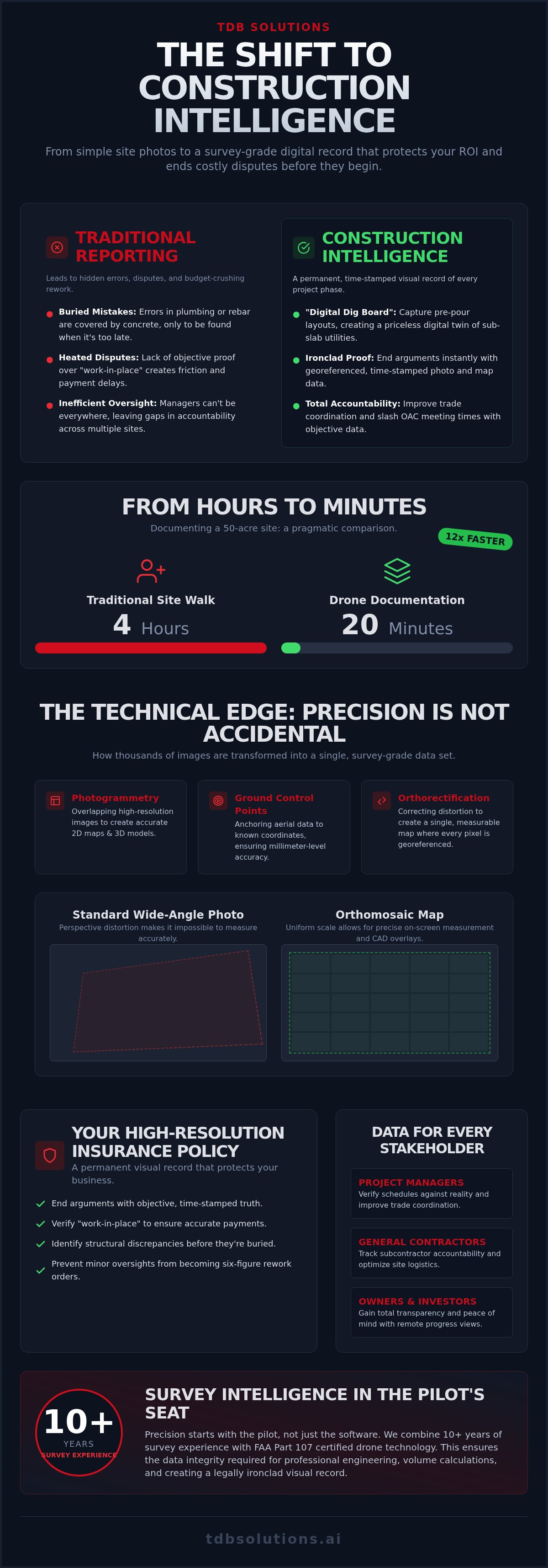
- Replace grueling four-hour site walks with drone progress documentation construction that maps a 50-acre site in just 20 minutes.
- Learn to integrate survey-grade aerial data into your existing Procore or BIM 360 workflows for improved trade accountability.
- See how combining 10+ years of survey experience with FAA Part 107 technology provides an ironclad visual record for legal protection.
What is Drone Progress Documentation for Construction?
Drone progress documentation construction isn't just about taking pictures from the sky. It's a systematic, recurring data collection process. You get a time-stamped, georeferenced visual record of every square inch of your jobsite. By 2026, the industry has moved past simple "site photography." We call it Construction Intelligence. It's the difference between a pretty picture and actionable data that moves a project forward. This process creates a "Digital Dig Board." We capture plumbing, electrical, and rebar layouts before the pour. Once the concrete is down, that data is priceless. You'll never have to guess where a utility line sits.
Different stakeholders need different views of this data. Project managers use it to verify schedules against reality. General contractors use drone progress documentation construction to track trade accountability and site logistics. Owners and investors gain peace of mind through total transparency, seeing exactly what their capital is building without needing to be on-site every day.
The "Insurance Policy" of Aerial Documentation
Think of aerial data as a high-resolution insurance policy. A permanent visual record protects your business against litigation and payment disputes. If a subcontractor claims they finished a phase on Tuesday, but the drone shows an empty slab on Wednesday, the argument ends immediately. It's objective truth. Verifying "work-in-place" ensures you only pay for what's actually been built. Survey-grade aerial records identify structural discrepancies before they are buried, preventing minor oversights from evolving into six-figure rework orders.
Why 2026 Construction Standards Demand Aerial Data
Houston projects are getting bigger and more complex. Managing a site in League City while you're in an OAC meeting in Downtown Houston is a logistical hurdle. Aerial data bridges that gap. Investors can see progress without a six-hour round trip. Site safety also improves. You can spot hazards like improper trenching or unsecured materials from the air without putting staff in a dangerous zone. The variety of drone applications in modern building continues to expand. This makes high-end data collection a standard requirement for any serious builder in the Greater Houston area.
The Technical Advantage: Photomosaics, Orthomosaics, and Precision
Standard photography is a snapshot. An orthomosaic is a data set. Most people see a drone and think of marketing photos. We see a high-precision tool for data capture. Effective drone progress documentation construction requires more than just a bird's-eye view. It requires georeferenced maps where every pixel represents a real-world coordinate. This is the difference between "looks about right" and "is exactly right."
Precision is not accidental. We achieve it through several technical layers:
- Photogrammetry: We overlap hundreds of high-resolution images to create 2D maps and 3D site models.
- Ground Control Points (GCPs): These physical markers on the ground anchor the aerial data to known coordinates.
- Millimeter-Level Accuracy: GCPs ensure your digital site model matches the actual terrain with extreme precision.
- Survey-Grade Hardware: We use equipment designed for data integrity, not just social media clips.
Consumer-grade drones are toys for hobbyists. They don't belong on a professional jobsite where millions are at stake. When you need data that engineers can actually use for volume calculations or site grading, you need a technical partner who understands the math behind the flight. Verify your site's accuracy with Construction Intelligence that experts can trust.
Orthomosaics vs. Standard Photography
Standard wide-angle photos suffer from perspective distortion. Objects at the edges look tilted. You can't measure distance on a regular photo. Orthorectified images solve this by correcting the camera tilt and terrain relief. This allows you to perform accurate on-screen measurements directly from your browser. You can overlay CAD drawings onto these maps to check for structural alignment. If a foundation is off by three inches, you'll see it on the map before the walls go up. Consistent flight paths allow for week-over-week site comparisons, highlighting exactly how much earth was moved or how much steel was hung.
Survey Intelligence in the Pilot’s Seat
Precision starts with the pilot, not just the software. Dillon Bates brings 10+ years of survey experience to every mission. This background is critical for data integrity. We know how to avoid common pitfalls like sun glare, motion blur, or insufficient overlap that ruins technical imagery. Every flight is conducted by FAA Part 107 certified pilots, ensuring legal compliance and safety on active jobsites. We don't just deliver files. We deliver engineering-grade intelligence that helps you catch errors before they become permanent. It's about providing a "straight-talk" assessment of your site's progress through the lens of technical expertise.
Drone Monitoring vs. Traditional Site Walks: A Pragmatic Comparison
Traditional site walks are a drain on your most valuable resource: time. Walking a 50-acre Houston site takes a supervisor roughly four hours of constant movement. A drone completes that same mission in 20 minutes. That is a massive reduction in man-hours. You gain back half a day of productivity while receiving a more comprehensive data set. Speed is the obvious winner, but the real value lies in the quality of the intelligence gathered.
Ground-level perspectives are limited. You can only see what is right in front of you. Drones capture angles and elevations that are physically impossible to reach from a ladder or a truck bed. This bird's-eye view reveals site-wide logistics issues that ground walks simply miss. Safety is another critical factor. Every minute a staff member spends navigating active heavy-machinery zones or unstable terrain is a minute of unnecessary risk. High-resolution drone progress documentation construction keeps your team out of harm's way while providing better visibility than ever before.
Data centralization is the final blow to the old way of doing things. Most projects suffer from "photo bloat." You have different trades taking hundreds of unorganized phone photos that sit in siloed text threads or private cloud folders. TDB Solutions replaces this chaos with a single "Source of Truth." Every image is georeferenced and time-stamped, creating a logical, searchable record of the entire build.
The "Invisible" Data: What Site Walks Miss
Site walks only document what is currently visible. We focus on what is about to be buried. We document utility trenching and rebar placement with survey-grade precision before the concrete pour. For large projects in Galveston or League City, we identify subtle drainage issues and topographical changes that a human on the ground would never notice. Our thermal inspection capabilities can even spot electrical hotspots or moisture trapped in roofing materials before they evolve into costly rework orders. This is proactive management, not reactive firefighting.
Boosting OAC Meeting Efficiency
Owner, Architect, and Contractor (OAC) meetings usually involve a lot of guesswork and finger-pointing. Aerial side-by-side comparisons end the "he-said, she-said" trade conflicts instantly. You have objective visual proof to justify change orders or timeline extensions. Instead of wasting time scrolling through 100+ unorganized phone photos, you simply pull up a georeferenced map and zoom in on the exact coordinate in question. This level of clarity keeps meetings focused on solutions rather than arguments over what happened last Tuesday.
Implementation: Integrating Drone Data into Your Workflow
Adding drone progress documentation construction to your project isn't a disruption. It's a refinement. For a smooth rollout, we focus on three pillars: cadence, compatibility, and communication. You don't need to be a tech expert to use this data. We handle the heavy lifting of collection and processing so you can focus on making decisions. By 2026, AI has streamlined this even further. Algorithms now assist in automated milestone detection and trade tracking, flagging potential schedule slips before they become critical delays.
Before the first flight, site prep is simple but vital. We notify your crews and establish safe landing zones away from heavy equipment. This keeps the site running without interruption. Data delivery is just as seamless. We provide data in several formats to fit your existing tech stack:
- Direct integration with Procore and BIM 360 for seamless project management.
- High-resolution georeferenced orthomosaics for engineering and CAD overlays.
- Standardized PDF reports for quick distribution to subcontractors and owners.
- Secure cloud-based links for real-time 3D model viewing and measurements.
Choosing Your Flight Cadence
Your documentation schedule should mirror your project's intensity. During earthwork and foundation phases, things change fast. We recommend bi-weekly or even daily flights to capture underground utilities before they vanish. Once you hit vertical construction, a weekly cadence usually suffices. This captures exterior skin progress and roofing milestones perfectly. At project completion, we conduct a final flight to create a definitive "As-Built" visual record. This digital twin is a powerful asset to hand over to the owner.
From Data to Decisions
Raw photos are just the start. We use site comparison tools to track earth-moving progress and stockpile volumes with mathematical precision. You can share these cloud-based links with remote stakeholders in Friendswood or Pearland instantly. They see what you see. We also prioritize cybersecurity. Your sensitive commercial data is protected with enterprise-grade encryption. This ensures your site intelligence stays private and secure. Ready to streamline your site management? Explore our Construction Intelligence services today.
Construction Intelligence with TDB Solutions: The Houston Standard
TDB Solutions sets the standard for construction intelligence in Texas. We don't just fly drones. We deliver high-precision data that drives results for the region's most demanding builders. Our team brings 10+ years of professional survey experience to every jobsite. This expertise matters when accuracy is non-negotiable. We bridge the gap between technical aerial data and the practical needs of general contractors. Whether you're breaking ground in Pearland or finishing a complex build in Downtown Houston, our drone progress documentation construction provides the ironclad record you need to protect your margins.
We pride ourselves on being a results-oriented partner. Our local focus allows for rapid deployment across Friendswood, Pearland, and Galveston. We don't offer generic services. We provide tailored data solutions that help you manage multiple remote sites with total confidence. By combining survey-grade heritage with FAA Part 107 technology, we ensure your data is legally defensible and technically sound.
Your Boots-on-the-Ground Partner in Houston
Houston weather is notoriously unpredictable. High humidity and shifting wind factors can ruin a flight or compromise data quality. We understand these local patterns intimately. We monitor conditions in real-time to ensure every mission is safe and every data set is clean. Airspace management is another critical local hurdle. Many prime development sites sit in controlled airspace near Hobby or IAH. We navigate these complex FAA authorizations so your project stays on schedule without legal risk. You get direct access to our founder, Dillon Bates, for technical data consultation. You're not just hiring a vendor. You're gaining a partner who understands the dirt and the data.
Scaling Your Brand with Construction Media
Your technical data has a second life. We repurpose survey-grade assets into high-end marketing media production through our creative division. This isn't just generic footage. It's a visual narrative of your firm's technical capability and commitment to transparency. We combine high-resolution aerial views with "mic'd up" interviews to showcase your team's expertise in action. Use this content to dominate your next big RFP. Consistent drone progress documentation construction helps you prove your project management prowess to potential clients. It's a pragmatic way to scale your brand while maintaining a permanent record of your craftsmanship. We handle the heavy lifting so you can focus on building your legacy.
Get a custom Construction Intelligence quote from TDB Solutions
Future-Proof Your Jobsite with Survey-Grade Intelligence
The construction industry doesn't wait for those who rely on outdated reporting. By adopting drone progress documentation construction, you transition from reactive troubleshooting to proactive site management. You've seen how survey-grade orthomosaics and 3D models replace the guesswork of traditional site walks. These tools provide a permanent, time-stamped record that protects your business from disputes and costly rework. It's about having total visibility from the dirt to the roof.
TDB Solutions brings a "boots-on-the-ground" perspective to every project. We combine FAA Part 107 certification with 10+ years of professional survey experience to deliver data that engineers and project managers actually trust. Our local Houston expertise means we navigate regional weather and complex airspace while you focus on the build. Don't let your next project be undermined by buried errors or unverified progress.
Secure your jobsite data with TDB Solutions’ Construction Intelligence. We are ready to help you build with more speed, more clarity, and absolute precision.
Frequently Asked Questions
Is drone progress documentation legal for construction sites in Houston?
Yes, drone progress documentation construction is fully legal in Houston when conducted by FAA Part 107 certified pilots. We handle the complex airspace authorizations required for sites near Hobby Airport and IAH. Our team ensures every flight complies with current 2026 federal regulations, including Remote ID requirements. This provides you with a legitimate, documented record of your project without the risk of regulatory fines or site shutdowns.
How often should I schedule drone flights for my construction project?
Most Houston builders find that a weekly or bi-weekly cadence is ideal for tracking vertical progress. However, during critical earthwork or foundation phases, you might require higher frequency flights to capture underground utilities before they are covered by concrete. We tailor the schedule to your project's specific milestones, ensuring you have the data you need for OAC meetings and subcontractor accountability throughout the entire build cycle from Friendswood to Galveston.
Can drone data replace traditional land surveying for my site?
Drone data provides high-precision construction intelligence, but it cannot replace the legal boundary work performed by a Licensed Land Surveyor. TDB Solutions does not offer licensed surveying services. Instead, we provide survey-grade aerial data that supplements your site management. This data is used for volume calculations, site grading checks, and visual documentation, giving your team an accurate digital twin of the project's current state without the legal weight of a boundary survey.
What kind of reports will I receive from a drone progress flight?
You receive a comprehensive suite of actionable data tailored to your project. This includes high-resolution orthomosaic maps, 3D site models, and georeferenced point clouds. We also provide side-by-side visual comparisons that highlight week-over-week progress. These reports are delivered through secure cloud links, allowing your stakeholders in Pearland or League City to view the site remotely. Our goal is to provide a straight-talk visual summary that makes decision-making faster and more accurate.
Do I need to clear the site or stop work while the drone is flying?
You don't need to stop work or clear the site during our flights. Our FAA-certified pilots operate drones at altitudes that don't interfere with active machinery or crews. We only require a small, designated landing zone that remains clear for takeoffs and landings. This boots-on-the-ground approach ensures your project stays on schedule while we capture the high-precision data needed for your progress tracking without causing any site downtime.
How does aerial documentation protect me in a legal dispute?
Aerial documentation provides an ironclad, time-stamped visual record of every construction phase. If a subcontractor disputes a payment or a trade covers up an error, you have objective proof of the site's condition on a specific date. This digital paper trail is invaluable for resolving conflicts during OAC meetings. It acts as a survey-grade insurance policy, protecting your ROI by capturing details that are eventually hidden behind walls or under concrete.
Can drones track interior construction progress as well?
Drones are highly effective for tracking exterior progress, but interior tracking often requires different specialized equipment like 360-degree cameras or handheld LiDAR scanners. While we specialize in aerial data, we can coordinate comprehensive documentation that links exterior site maps with interior progress. This ensures a seamless record of the entire structure. For Houston projects, this holistic approach provides total transparency for investors and owners who can't visit the site in person.
What file formats are provided for integration with my existing software?
We provide data in industry-standard formats to ensure seamless integration with your existing tech stack. This includes GeoTIFFs for orthomosaics, .obj or .fbx files for 3D models, and .las or .laz files for point clouds. Our data integrates directly with platforms like Procore and Autodesk BIM 360. This allows your team to overlay aerial maps onto CAD drawings or Revit models, making it easy to spot structural discrepancies before they become expensive rework.

