

Driving through Houston traffic to check a single foundation pour is a leak in your profit margins. You spend hours every week stuck on the 610 loop just to confirm work that should've been finished yesterday. It's frustrating. You need to know exactly what's happening on-site, but manual reports are often late or lack the precision required for real decision-making. Learning how to track construction progress remotely is no longer a luxury for 2026. It's a competitive necessity for any builder managing multiple projects or reporting to out-of-state investors.
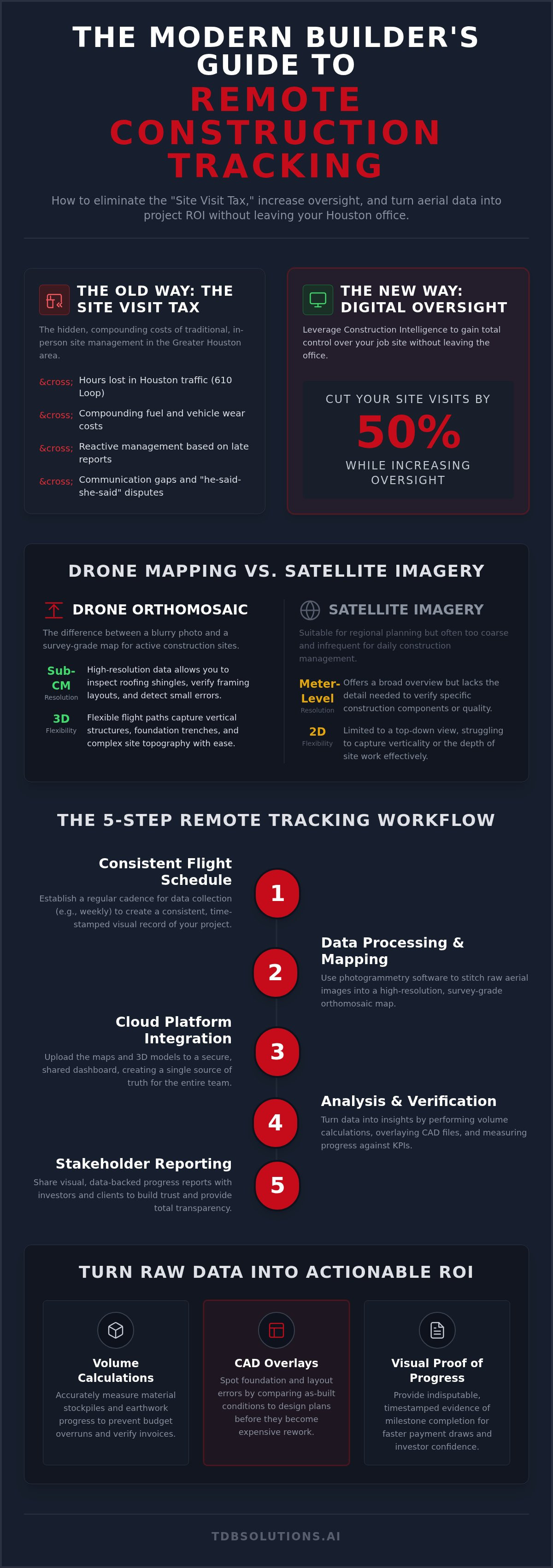
You can cut your site visits by 50% while actually increasing your oversight. This guide shows you how. We'll dive into the technical workflows and Construction Intelligence tools that deliver survey-grade accuracy directly to your desk. You'll learn to use high-resolution aerial data to detect errors before they become expensive rework. From automated drone flights to cloud-based visual proof; we're breaking down the exact systems used to maintain total control over your Houston job site without leaving the office.
Key Takeaways
- Eliminate the "Site Visit Tax" by swapping hours in Houston traffic for digital oversight. You'll reclaim lost productivity and fuel costs by monitoring your site from the office.
- Discover why drone-based orthomosaic mapping provides higher resolution and more measurable data than traditional satellite imagery. It's the difference between a blurry photo and a survey-grade map.
- Learn how to track construction progress remotely using a 5-step workflow that integrates consistent flight schedules with targeted KPIs. This ensures you never miss a milestone or a critical site deviation.
- Turn raw aerial data into actionable ROI through volume calculations and CAD overlays. These tools spot foundation errors and material stockpile discrepancies before they eat your budget.
- Leverage a Houston-based partner that combines FAA-certified drone operations with over a decade of survey experience. Get actionable Construction Intelligence built for the local market's unique challenges.
The High Cost of the 'Site Visit Tax': Why Remote Tracking is Essential
Remote construction progress tracking is more than just a convenience. It's a high-tech workflow that uses digital tools to monitor your site status from any location. Instead of relying on a physical presence, you leverage data. This shift moves your operation from reactive site management to proactive Construction Intelligence. You stop guessing and start knowing. It's the only way to scale your business without doubling your fuel budget.
Traditional oversight relies on the "Site Visit Tax." This is the hidden, compounding cost of fuel, vehicle wear, and lost productivity. Every hour your best people spend in a truck is an hour they aren't solving problems or closing new contracts. By mastering how to track construction progress remotely, you stop paying this tax. You bridge the communication gap between field crews and office stakeholders with a single, digital bridge.
Eliminating Windshield Time in Greater Houston
Managing projects across Pearland, League City, and downtown Houston is a logistical nightmare. Houston traffic is a predator that eats your profit margins. A simple site check-in can easily turn into a four-hour round trip. It's exhausting. It's inefficient. And in 2026, it's unnecessary.
A 15-minute digital review of your site now replaces those grueling commutes. You gain back your mental bandwidth. Instead of managing by proximity, you manage by exception. You only head to the site when the data flags a specific issue. This approach keeps your focus on high-value tasks. You spend your energy on construction management strategy rather than fighting for a spot on the 610 loop. The result? You do more work with fewer headaches.
The Single Source of Truth for Stakeholders
Communication gaps often lead to "he-said-she-said" disputes on the job site. Field crews might report one status while the office expects another. These friction points cause delays. Shared digital dashboards eliminate this confusion instantly. They provide a single source of truth that everyone can see, regardless of their physical location.
This visibility is vital for out-of-state investors. They need to see progress before they release the next round of funding. High-resolution visual data provides an indisputable record of site conditions at specific dates. It's a permanent, timestamped archive of the build. When you know how to track construction progress remotely, you provide stakeholders with total transparency. You build trust through data, not just promises. This level of professional reporting sets you apart from every other builder in the Houston market.
The Remote Tracking Tech Stack: Drones, Mapping, and Software
Success in remote monitoring depends on the quality of your data. You can't manage what you can't measure accurately. Learning how to track construction progress remotely requires a shift from casual photography to technical data collection. This tech stack is the backbone of your virtual job site. It combines professional-grade drones, specialized photogrammetry software, and secure cloud platforms to host massive datasets.
Every piece of this stack must work in unison. Cloud platforms allow you to share 3D models and high-res maps with your entire team instantly. However, the software is only as good as the raw data you feed it. This is why FAA Part 107 certification is a non-negotiable requirement. It ensures your data is collected legally, safely, and professionally. It's about more than just flying; it's about compliant data acquisition.
High-Resolution Aerial Data vs. Satellite Imagery
Satellite imagery has its place in regional planning, but it's often too coarse for active construction. While high-resolution satellite imagery offers a broad overview, it typically provides meter-level accuracy at best. Drones deliver sub-centimeter resolution. You need that level of detail to inspect roofing shingles or verify framing layouts. Satellites also struggle with verticality. Drones offer flexible flight paths to capture the side of a structure or the depth of a foundation trench.
The primary output of these flights is the orthomosaic. An orthomosaic is a geometrically corrected aerial image with a uniform scale that allows for accurate distance measurements across the entire map. It's essentially a high-resolution, measurable digital twin of your project. This level of detail makes it possible to spot a missing pier or a shifted utility line from your office chair. It's the difference between seeing a site and understanding it.
The Role of Survey-Grade Intelligence
Data accuracy is the difference between a helpful map and a costly mistake. This is why a background in surveying is critical. Our founder brings over 10 years of survey experience to every flight. We use Ground Control Points (GCPs) to anchor digital maps to precise real-world coordinates. Without GCPs, your digital map is just a floating image. With them, it becomes a survey-grade tool that integrates directly into your existing BIM (Building Information Modeling) workflows.
This technical rigor ensures your aerial data is actually usable for volume calculations and site planning. It provides the confidence needed to make multi-million dollar decisions without being on-site. If you're ready to upgrade your oversight, our Construction Intelligence services provide the precision your Houston projects demand. You get actionable data that moves the needle, not just pretty pictures.
5 Steps to Implement a Remote Progress Tracking Workflow
Establishing a professional system for how to track construction progress remotely requires more than a drone and a pilot. It's a disciplined workflow designed to turn raw data into Construction Intelligence. You need a process that scales with your project. Follow these five steps to build a reliable remote monitoring system:
- Establish a consistent flight schedule: Set a weekly or bi-weekly rhythm. Consistency allows you to compare site status over time with precision.
- Define your Key Performance Indicators (KPIs): Know exactly what you're measuring. Focus on earthworks volumes, foundation slab accuracy, or framing milestones.
- Select a delivery format: Choose between high-resolution orthomosaic maps, interactive 3D models, or standard progress photos based on stakeholder needs.
- Standardize the reporting process: Create a central portal or dashboard. Stakeholders should know exactly where to find the latest updates every Friday.
- Iterate based on project phases: Adjust your data collection as the build evolves. Move from high-density site prep data to visual inspections during interior finishes.
Setting the Flight Frequency
Your flight frequency must match the pace of your build. Earthworks and site grading move fast. During these phases, daily or every-other-day flights prevent expensive grading errors. Once you move to vertical framing, a weekly schedule is usually sufficient. Consistent flight paths are vital. They create a "time-lapse" effect that makes it easy to spot deviations from the original schedule.
Weather in the Galveston and Houston area is a major variable. High winds and sudden thunderstorms can delay data collection. We plan flights around these windows to ensure the highest data quality. By maintaining a rigid schedule, you ensure your remote oversight never lags behind the actual work being done in the field.
Distributing Actionable Data to the Team
Data is useless if it stays on a hard drive. You need to get it into the hands of decision-makers fast. Web-based viewers are superior for project managers who need to measure distances or volumes. Conversely, simple PDF reports are often better for out-of-state investors who just want a high-level visual summary.
You can tag specific site issues directly on the digital map. If there's a safety hazard or a misplaced material pile, mark it. This creates an indisputable record for your field crew. Adding "mic'd up" project updates provides the human context that raw data lacks. This combination of technical precision and clear communication is the secret to how to track construction progress remotely without losing the "boots-on-the-ground" feel of a traditional site visit.
Actionable Insights: Turning Aerial Data into ROI
Data is only as valuable as the money it saves you. Pretty pictures don't build projects; actionable intelligence does. When you understand how to track construction progress remotely, you stop guessing about site conditions and start managing by the numbers. This transition turns your aerial data into a measurable return on investment by identifying waste and preventing errors before they compound. It's about protecting your bottom line from the office.
Volume Calculations and Earthwork Tracking
Stockpile management is a notorious profit-drainer. Traditional methods for measuring dirt or gravel are slow and often inaccurate. Drones change that. They calculate the volume of material moved or remaining in seconds. You get precise numbers that prevent overcharging on material hauling or site grading. You know exactly how much fill you've used and how much you still need to order.
Disputes with subcontractors regarding grading often stall progress. These arguments vanish when you provide survey-grade data. Because our team has over a decade of survey experience, our volume calculations are accurate to within 1-3%. This level of precision ends the "he-said-she-said" era of site management. You have the data. They have the bill. The math doesn't lie.
CAD Overlays and Deviation Detection
The most expensive type of construction delay is rework. Breaking up cured concrete because a utility line was six inches off is a nightmare. CAD overlays solve this through a process called "ghosting." We take your architectural plans and overlay them directly onto the current, high-resolution site map. This allows you to spot deviations in real-time.
You catch a misplaced pier or a foundation shift before the first yard of concrete is poured. It's a proactive shield for your budget. By integrating these digital checks, you master how to track construction progress remotely while maintaining a level of quality control that traditional walk-throughs simply cannot match. You see the error while it's still just a digital discrepancy, not a physical catastrophe.
The value extends beyond the build phase. "As-built" documentation provides a permanent record of what lies beneath the slab or inside the walls. This data is gold for future maintenance and insurance claims. Additionally, aerial inspections identify roof damage or installation errors without the risk of ladders or safety incidents. It's faster, safer, and more thorough. If you're ready to stop bleeding cash on site errors, our Construction Intelligence services provide the technical oversight you need to protect your margins.
TDB Solutions: Your Houston Partner for Construction Intelligence
TDB Solutions isn't a generic software company based in Silicon Valley. We're your local Houston partner. From Friendswood to Galveston; we understand the local terrain and the unique challenges of Texas-sized projects. We don't just fly drones. We provide a comprehensive system for how to track construction progress remotely that's grounded in real-world expertise. Our goal is to handle the technical heavy lifting. You focus on building.
Our approach is built on "Construction Intelligence." We don't just deliver a folder full of photos. We deliver actionable site data that you can use to make decisions. This local, boots-on-the-ground presence makes us a reliable ally for Houston developers. We know the humidity, the traffic, and the stakes. We're here to ensure your project stays on track and under budget through every phase of development.
The TDB Solutions Difference: Survey-Backed Accuracy
Survey-backed accuracy is our core foundation. Our founder, Dillon Bates, brings over 10 years of survey experience to every flight. This level of expertise is rare in the drone industry. Most pilots can take a photo; few can ensure that photo is accurate enough for professional measurements. "Good enough" photography isn't sufficient when you're pouring millions into a foundation. You need data you can trust for every calculation.
Professional construction tracking requires survey-grade precision. We use FAA Part 107 certified pilots who know how to anchor digital maps to real-world coordinates. This ensures your aerial data integrates perfectly with your existing workflows and CAD designs. It's the difference between a pretty picture and a technical tool. We invite you to see a demo of our Houston-based project tracking in action to see the difference for yourself.
Full-Spectrum Media: From Intelligence to Marketing
We offer more than just technical data. Every flight is an opportunity to showcase your project's success. The same aerial data used for volume calculations can produce high-end marketing media. We bridge the gap between technical intelligence and brand development. This dual-purpose approach maximizes your ROI on every site visit we perform. You get the data you need for the office and the media you need for the public.
We can even integrate "mic'd up" interviews with Houston business owners into your progress updates. This adds human context to the digital proof. It's a powerful way to communicate status to out-of-state investors or potential tenants. We provide a complete narrative of your project's growth from site prep to ribbon cutting. If you're ready to master how to track construction progress remotely with a partner you can trust; we're ready to get to work. Contact TDB Solutions for a Construction Intelligence Consultation today.
Take Control of Your Job Site from the Office
Remote monitoring isn't just about photos. It's about data that protects your margins. You've seen how high-resolution orthomosaics and CAD overlays catch errors before they become expensive rework. You understand how to track construction progress remotely by swapping windshield time for actionable Construction Intelligence. This shift saves your team hours of travel through Houston traffic while providing investors with indisputable visual proof.
TDB Solutions brings over 10 years of survey experience to every project. We are FAA Part 107 certified and serve the entire region from Houston and Pearland to Galveston. We don't just fly; we ensure your data is accurate and measurable. It's time to stop guessing and start managing with precision.
Ready to optimize your workflow? Get a Custom Construction Intelligence Quote for Your Houston Project today. Your next build deserves the clarity of professional aerial oversight.
Frequently Asked Questions
How accurate is drone-based construction progress tracking?
Drone tracking is extremely accurate, often achieving sub-centimeter resolution when anchored with Ground Control Points. Because our founder has over 10 years of survey experience, we ensure your data is technically sound for precise measurements. This precision allows you to detect foundation shifts or utility deviations that a standard walk-through might miss. You get actionable intelligence instead of just visual estimates. It's the professional standard for modern oversight.
Do I need to be on-site when the drone is flying?
No, you don't need to be present during the flight. The primary goal of learning how to track construction progress remotely is to save you time. Our FAA Part 107 certified pilots handle the entire data collection process autonomously. You can stay in your office in Pearland or downtown Houston while we capture the site. We provide the digital proof of work completed so you can review it on your own schedule.
Can drone data be integrated into Procore or Autodesk?
Yes, our technical data integrates seamlessly with industry-standard platforms like Procore and Autodesk. We provide exports in formats compatible with BIM workflows, such as .obj or .tiff files. This allows your design team to overlay current site conditions directly onto original CAD plans. It streamlines communication between the field and the office; ensuring everyone works from the same source of truth. You gain a digital bridge for your entire team.
Is it legal to fly drones over construction sites in Houston?
It is legal to fly over Houston construction sites provided the pilot is FAA Part 107 certified for commercial operations. We manage all necessary airspace authorizations and follow strict safety protocols. Flying commercially without this certification is illegal and creates liability for the project owner. We handle the regulatory compliance so you don't have to worry about local ordinances or federal flight restrictions in the Greater Houston area.
How much does remote construction tracking cost compared to manual site visits?
Remote tracking typically costs significantly less than the "Site Visit Tax" associated with traditional oversight. When you calculate the hourly rate of a senior project manager plus fuel and vehicle wear in Houston traffic, the savings are clear. You reduce site visits while increasing the frequency of inspections. It's a more efficient way to allocate your budget while gaining higher-resolution data than manual reporting provides. You trade windshield time for profit.
What happens if there is bad weather on the scheduled flight day?
We monitor Houston's unpredictable weather closely and reschedule flights if conditions are unsafe. High winds or heavy rain can compromise both safety and data quality. Because we are a local partner based in the area, we quickly pivot to the next available clear-sky window. You won't be charged for weather delays; we simply adjust the schedule to ensure the data we deliver is crisp and usable for your project needs.
How quickly can I see the data after the drone finishes its flight?
You can typically access processed data within 24 to 48 hours after a flight. While raw photos are available almost immediately, generating high-resolution orthomosaic maps and 3D models requires significant computing power. This processing time ensures that the final Construction Intelligence you receive is geometrically accurate and ready for measurement. We prioritize speed to ensure you can make timely decisions based on current site status without any unnecessary delays.
What is the difference between an aerial photo and an orthomosaic map?
An aerial photo is a single snapshot with perspective distortion, while an orthomosaic map is a geometrically corrected digital twin. Orthomosaics combine hundreds of photos into a single, uniform-scale image. This allows you to measure distances, areas, and volumes with survey-grade precision. If you're figuring out how to track construction progress remotely, the orthomosaic is the tool you need for actual site analysis, planning, and indisputable documentation of your build's progress.


