

Sending a crew up a 150-foot scaffold isn't just expensive. It's a massive liability that your project timeline doesn't need. You've likely felt the frustration of waiting days for a manual inspection report only to receive inconsistent data and blurry photos. It's a bottleneck that slows down maintenance and inflates your overhead. That's why leading firms are switching to drone asset inspection services Houston to replace outdated, dangerous methods with high-precision aerial data.
We understand that you need actionable intelligence, not just pretty pictures. We're here to show you how survey-grade drone data provides a faster, safer, and more accurate way to monitor your critical infrastructure. You'll discover how to slash inspection downtime, eliminate unnecessary safety risks, and gain a clearer ROI on your construction progress. From high-resolution thermal sensors to 3D digital twins, we'll break down the tools that are setting a new standard for Houston's industrial landscape. It's time to stop guessing and start making decisions based on data you can trust.
Key Takeaways
- Understand how Houston's unique climate drives the need for high-frequency inspections to catch structural issues before they become catastrophic failures.
- Learn why survey-grade accuracy is non-negotiable for drone asset inspection services Houston when measuring volumes or identifying micro-cracks in critical infrastructure.
- See the direct impact on your bottom line when you replace slow, manual inspections with rapid-deployment UAVs that keep your team safely on the ground.
- Explore how tailored drone solutions support the specific needs of the Houston energy corridor and commercial developments in Pearland and Friendswood.
- Discover how to integrate Construction Intelligence into your workflow to bridge the gap between technical site data and professional stakeholder reporting.
What is Drone Asset Inspection and Why Does Houston Need It?
Drone asset inspection isn't just about taking pictures from the sky. It's the strategic use of an Unmanned aerial vehicle (UAV) to capture high-resolution, technical data of physical assets. In a city as industrial and sprawling as ours, drone asset inspection services Houston provide a level of oversight that manual walk-throughs simply can't match. We use survey-grade sensors to detect structural anomalies long before they lead to catastrophic failure. It's the difference between seeing a building and truly understanding its condition.
Our local climate is brutal on commercial property. The relentless humidity and frequent storm cycles accelerate the degradation of steel, concrete, and roofing systems. If you're managing a property in the energy corridor or a high-rise downtown, you're fighting a constant battle against oxidation and moisture intrusion. We typically inspect a wide range of critical assets, including:
- Commercial roofing and complex drainage systems.
- High-rise building facades and glazing.
- Cellular and telecommunications towers.
- Active construction infrastructure and site stockpiles.
Most drone operators offer visual inspections. They give you a folder of photos and call it a day. We provide asset intelligence. This means we deliver actionable data that engineers and project managers can use for precise assessments or insurance claims. We don't just show you a crack; we measure its depth and track its growth over time.
The Role of Construction Intelligence in Asset Management
Data only becomes intelligence when it's analyzed and formatted for decision-making. For developers and managers, this means having accurate "as-built" documentation. It bridges the gap between what was planned and what was actually constructed on the ground. By leveraging construction intelligence drone data, property managers can track project progress with millimeter precision. It's about creating a digital historical record of an asset's health. This level of detail is vital for long-term maintenance planning and verifying contractor work.
Houston’s Unique Environmental Challenges
Gulf Coast heat and salt air don't play fair. These elements degrade industrial coatings and compromise structural integrity faster than in inland cities. Drone asset inspection services Houston allow for a proactive strategy rather than a reactive one. You can spot salt-induced corrosion on HVAC units or facade cracks before they cause a major leak. Because Houston sits in some of the busiest, most complex airspace in the country, you can't hire a hobbyist. You need FAA-certified pilots who understand local flight restrictions and safety protocols. We bring over ten years of survey experience to every flight. This ensures your data is reliable, compliant, and ready for the boardroom.
The TDB Advantage: Survey-Grade Data for Critical Assets
A drone is just a tool. The real value lies in the expertise of the person operating it. Many providers offer drone asset inspection services Houston as an add-on to their photography business. We don't. At TDB Solutions, we lead with over 10 years of survey experience. This background allows us to interpret aerial data with a level of technical depth that a standard photographer simply cannot provide. We don't just see a roof; we see a drainage gradient. We don't just see a facade; we see a structural vulnerability.
Our approach is rooted in straight-talk and pragmatism. We provide actionable outcomes that drive real-world business decisions. Every flight is conducted by an FAA Part 107 certified pilot. This isn't just about following the law. It's about maintaining the highest safety standards on your job site while ensuring your data is legally compliant for insurance or regulatory needs. We focus on grounded, tangible results that move your project forward.
Precision Matters: Beyond the Camera
There's a massive gap between a drone photo and survey-grade data. We utilize Real-Time Kinematic (RTK) technology to ensure centimeter-level GPS accuracy across every asset we map. This precision is vital for measuring stockpile volumes or identifying the exact location of structural cracks on a 20-story building. Photogrammetry is the technical process of turning high-resolution 2D images into accurate, measurable 3D models. Without this precision, your data is just a collection of pictures. It's the foundation for reliable aerial asset management.
Actionable Data for Houston Decision Makers
We deliver reports that speak the language of engineers and project managers. Our data fits directly into your CAD files or maintenance spreadsheets. By using sequential data, we track how your assets degrade over time. This turns overlooked maintenance issues into highly visible priorities. You gain the ability to predict failures before they happen. This proactive oversight helps Houston firms transition from reactive repairs to strategic asset intelligence. We handle the heavy lifting of data collection so you can focus on your craft.
Drone vs. Traditional Inspection: A Practical ROI Analysis
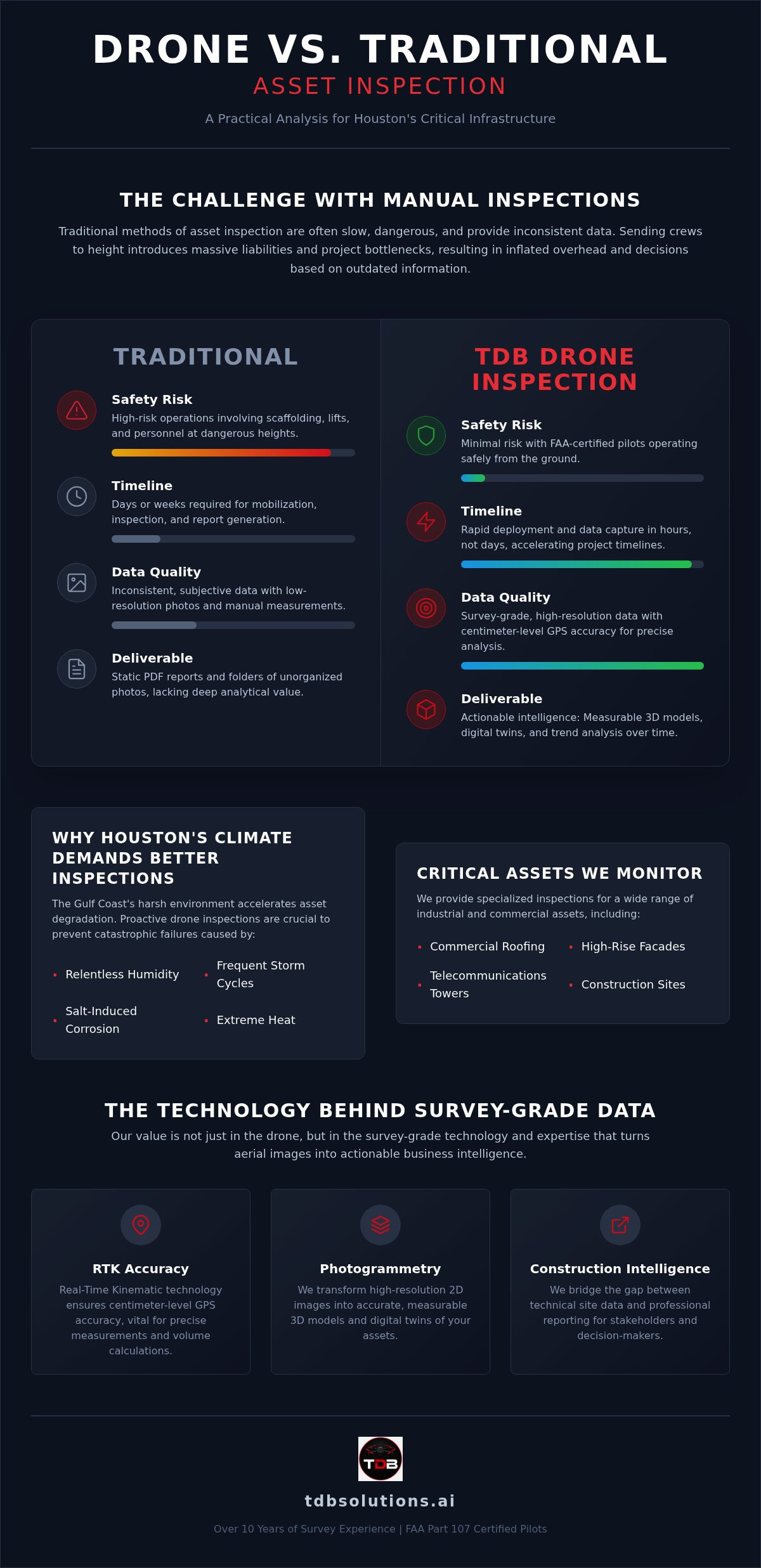
Traditional inspections are a logistical nightmare. You have to rent equipment, schedule specialized crews, and often shut down operations for days. This creates a massive hole in your budget before the first photo is even taken. By choosing drone asset inspection services Houston, you bypass these hurdles entirely. We deploy in minutes, not days. This speed translates directly into a higher ROI by keeping your site active and your personnel focused on their core tasks. It's a pragmatic shift from "how do we get up there?" to "what does the data tell us?"
The repeatability of aerial data is another hidden value. Manual walk-throughs are subjective. One inspector might catch a hairline crack that another misses. We use automated flight paths to ensure we capture the exact same data points every single time. This consistency allows you to compare year-over-year reports with millimeter precision. You aren't just getting a snapshot; you're building a historical record of asset health that stands up to professional scrutiny.
Cost Savings and Efficiency Gains
Think about the time it takes to erect scaffolding for a simple facade check. It's often a week-long process involving multiple vendors and permits. We can complete that same mission in a single afternoon. This efficiency gain isn't just about speed; it's about reducing the headcount on-site. A drone pilot and a technician replace a five-person crew and heavy lift equipment. For Houston construction projects, this prevents the cascading delays that happen when one inspection holds up three other trades. You get the data you need today so you can keep building tomorrow.
Hidden costs like site downtime and specialized liability insurance for high-altitude work add up fast. Drones eliminate these line items. We provide a lean, high-tech alternative that delivers superior results for a fraction of the traditional overhead. It's the smartest way to protect your margins while maintaining your infrastructure.
Mitigating Risk and Liability in Houston
Falls from heights remain the primary risk in asset inspection. Every time you send a human up a ladder or into a bucket lift, you're assuming a liability that could be avoided. Drones keep your boots on the ground. We handle the height, the wind, and the difficult angles while your team monitors the live feed from a safe distance. This no-nonsense approach to safety significantly lowers your risk profile and insurance exposure.
Having a digital record of every flight provides an indisputable trail for insurance and compliance. If a storm hits the Gulf Coast, you have "before and after" data ready for your claim. This documentation is vital for local firms that need to prove they've met maintenance standards. We handle the heavy lifting of risk management so you can focus on your craft with total peace of mind.
Specialized Drone Inspections for Houston’s Key Industries
Houston is a city defined by its scale. From the petrochemical complexes lining the Ship Channel to the massive distribution hubs in Katy, the sheer volume of infrastructure is staggering. Managing these assets requires more than a set of binoculars and a clipboard. Our drone asset inspection services Houston are designed to meet the specific technical demands of the Texas Gulf Coast. We provide the high-resolution data necessary to monitor energy assets, industrial warehouses, and the rapid suburban expansion in Pearland and Friendswood. This isn't just about taking pictures; it's about providing the technical oversight that keeps Houston's economy moving.
The ongoing infrastructure boom in Harris County places immense pressure on project timelines and safety standards. Whether it's a new highway interchange or a sprawling retail center in League City, the need for accurate, repeatable data is constant. We bridge the gap between traditional site visits and real-time project intelligence. Our "boots-on-the-ground" approach ensures that every flight delivers data that is both legally compliant and technically sound.
Construction and Infrastructure Oversight
We track site progress from the initial dirt work through to final completion. By using orthomosaic maps, we provide developers with a georectified, bird's-eye view of the entire project. These maps allow for precise site planning and keep stakeholders updated with a level of clarity that ground-level photos can't provide. Capturing high-resolution aerial data during the framing phase prevents costly "re-work" by catching structural deviations before they are buried behind drywall and masonry. This proactive oversight saves time and protects your margins. For projects that require absolute precision, our construction intelligence services provide the data you need to stay on schedule.
Commercial Property and Asset Integrity
For property managers in Galveston and Pearland, the salt air and high winds are constant threats to building integrity. We specialize in facade and roof assessments for large-scale industrial warehouses and retail centers. Using thermal imaging, we detect heat loss or moisture intrusion that is invisible to the naked eye. This allows you to identify a failing roof membrane or a compromised insulation layer before it leads to an expensive interior leak. By maintaining this level of technical oversight, local brands can ensure their facilities remain in peak condition. It's about moving your asset management from a state of being overlooked to a state of high visibility and professional standard.
Scaling Your Asset Management with TDB Solutions
Choosing a partner for drone asset inspection services Houston is about more than just equipment. It's about finding a local ally who understands the stakes of your project. TDB Solutions stands as a comprehensive partner for Houston’s construction and industrial sectors. We combine technical aerial data with a results-oriented focus. This dual approach helps you move from a state of being overlooked to a state of high visibility. We don't just provide a service; we offer a partnership built on straight-talk and grounded outcomes. Our boots-on-the-ground presence across the Greater Houston area ensures we're there when you need us most.
Our process is designed for speed and clarity. It begins with a deep-dive consultation. We identify your pain points, from high scaffolding costs to inconsistent reporting. Then, we deploy our FAA Part 107 certified pilots to capture survey-grade data. We don't stop at the flight. We analyze the results and deliver professional, actionable reports. This methodical flow ensures you have the intelligence needed to make decisive maintenance and construction choices. We handle the heavy lifting of data collection so you can focus on your craft.
From Data to Digital Presence
Your technical data has untapped marketing potential. The high-resolution imagery we capture for structural checks is the same media that can elevate your brand. We believe in a unified growth strategy. This means using technology to drive both site intelligence and market authority. If your infrastructure is world-class, your digital presence should be too. We help you showcase your asset quality through professional Houston web design. We turn your as-built documentation into a powerful conversion tool. It's a creative way to scale your business while keeping your team focused on their core work. We bridge the gap between technical excellence and digital visibility.
Ready for a Houston Site Assessment?
The Houston market is unique. You need a partner who knows the local airspace and the specific environmental risks of the Gulf Coast. We're already working in Friendswood, Pearland, and League City. This local expertise allows us to navigate complex flight paths and weather windows with ease. Don't settle for a detached corporate provider. Choose a problem-solver who understands the local landscape. We're ready to help you scale your asset management with precision and intelligence. Book your Houston drone asset inspection with TDB Solutions today.
Upgrade Your Infrastructure Oversight Today
Relying on manual inspections and outdated reporting is a risk your project doesn't need to take. We've shown how survey-grade aerial data transforms maintenance from a guessing game into a precise science. By choosing drone asset inspection services Houston, you eliminate the high costs of scaffolding and keep your team safely on the ground. You gain actionable intelligence that drives real ROI and keeps your project on schedule. It's about moving from a state of being overlooked to having total visibility over your most critical assets.
TDB Solutions brings over 10 years of survey experience and FAA Part 107 certification to every mission. We're your local boots-on-the-ground ally, serving Friendswood, Pearland, and Galveston with no-nonsense reliability. We handle the technical heavy lifting so you can focus on your craft. Stop settling for blurry photos and start making decisions based on millimeter-accurate data. It's time to leverage the technology that your competition is already using to scale.
Get a Precision Asset Inspection Quote from TDB Solutions and let's put your asset management on the fast track to growth.
Frequently Asked Questions
How much do drone asset inspection services cost in Houston?
Pricing for our services depends on the specific scope of your project, including the size of the asset and the complexity of the data analysis required. We avoid one-size-fits-all pricing to ensure you only pay for the intelligence you need. Factors like the total flight hours and specialized sensor types, such as thermal or high-res RGB, influence the final quote. We focus on delivering a high ROI by eliminating expensive equipment rentals.
Are drone inspections as accurate as manual inspections?
Drone inspections are often more accurate because they remove the human error associated with subjective manual checks. We use survey-grade sensors and RTK technology to capture data with millimeter precision across your entire property. This allows us to identify micro-cracks and structural anomalies that a manual inspector might miss from the ground. Our 10 years of survey experience ensures that the data is interpreted with professional technical depth and accuracy.
Do I need to be present during the drone inspection of my property?
You aren't required to be on-site while we conduct the flight mission. As long as we have the necessary access permissions and safety clearances, our FAA-certified pilots can handle the entire operation independently. We can even provide a live stream of the data capture if you want to monitor progress remotely from your office. After the mission, we deliver a comprehensive digital report, so you can review the findings at your convenience.
Is TDB Solutions FAA certified for commercial drone flights?
Yes, every pilot at TDB Solutions is FAA Part 107 certified for commercial operations. This certification is a legal requirement for any drone asset inspection services Houston provider. It ensures that we understand the complex airspace regulations of the Greater Houston area and maintain strict safety protocols on every job site. We take compliance seriously to protect your property and our professional standing while keeping your project moving forward without delays.
What kind of reports will I receive after a drone asset inspection?
We deliver actionable, technical reports tailored to your specific project goals. You might receive high-resolution orthomosaic maps, 3D digital twins, or detailed thermal analysis reports showing moisture intrusion. Our reports are formatted to integrate directly with your existing CAD software or maintenance management systems. We focus on providing intelligence that engineers and project managers can use to make immediate, data-driven decisions about their infrastructure. This bridges the gap between raw data and action.
Can drones perform inspections in the typical Houston wind and humidity?
Our industrial-grade drones are designed to handle the challenging Gulf Coast climate and salt air. We regularly fly in Houston's high humidity and can manage moderate wind speeds that would ground hobbyist equipment. However, we always prioritize safety and data quality. If weather conditions like heavy rain or extreme gusts compromise the precision of our sensors, we'll reschedule the flight to ensure your results are accurate. We don't take risks with your data.
How long does a typical aerial asset inspection take?
Most on-site flight operations are completed within a few hours for a standard site. A typical commercial roof or building facade check is significantly faster than traditional manual methods, which can take days to set up with scaffolding. The total turnaround time, including data processing and report generation, usually takes between 24 to 48 hours. This rapid deployment minimizes site downtime and allows you to address maintenance issues much faster than traditional inspection timelines.
What industries in Houston benefit most from drone data?
Houston’s petrochemical, energy, and construction sectors see the highest ROI from our specialized data. Large-scale industrial warehouses and retail centers in Pearland and Friendswood also rely on us for routine roof and facade assessments. Any industry managing critical infrastructure or high-value physical assets can use drone asset inspection services Houston to lower their liability. We help these firms maintain high visibility and professional standards through superior aerial data oversight and site intelligence.


