

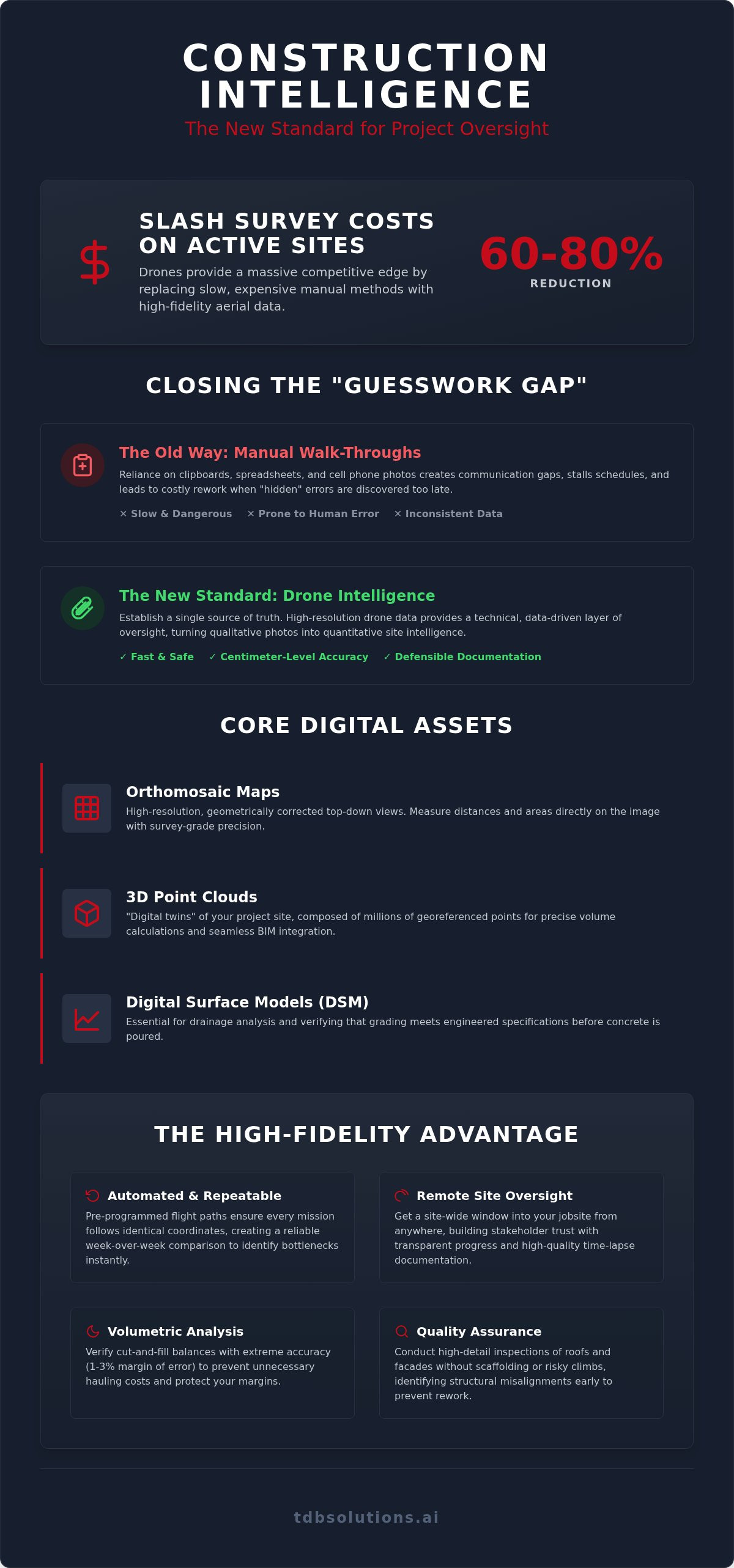
Drones can reduce survey costs by 60-80% on active construction sites. That's not just a statistic; it's a massive competitive edge for firms ditching the clipboard for high-fidelity aerial tech. In the Houston heat, manual inspections aren't just slow. They're dangerous and prone to human error. You need more than just a hobbyist with a camera. You need construction intelligence drone data that provides a technical, data-driven layer of oversight for your entire project.
We understand the headache of finding a grade error three weeks too late or dealing with communication gaps that stall your schedule. It's tough to manage a site when the field and the office aren't looking at the same map. This guide reveals how high-fidelity drone data transforms siloed operations into transparent, data-driven success stories. We'll show you how to establish a single source of truth that reduces project timelines, provides defensible documentation for stakeholders, and improves safety compliance across every acre of your jobsite. From volume calculations to progress tracking, discover the new standard for Houston project oversight.
Key Takeaways
- Stop relying on visual guesses. Learn how construction intelligence drone data converts raw aerial imagery into quantitative spatial insights for better decision-making.
- Discover why survey-informed data beats hobbyist photos. A decade of survey experience ensures the accuracy required for high-stakes Houston site oversight.
- Bridge the gap between the field and the office. See how automated flight paths and time-lapse documentation create a single source of truth for all stakeholders.
- Master the five-step workflow for implementation. From site calibration to identifying KPIs, we provide a roadmap for scaling your site's technical capabilities.
What is Construction Intelligence Drone Data?
Construction intelligence drone data is the bridge between a messy jobsite and a precise digital model. It isn't just about taking pictures from the sky. It's the synthesis of high-resolution aerial imagery, photogrammetry, and spatial data into actionable insights. While a standard drone photo shows you what the site looks like, intelligence data tells you exactly where everything is. It's a shift from qualitative site photos to quantitative site intelligence. This technical approach relies on an Aerial survey methodology to capture survey-grade detail that a manual walk-through simply can't match.
A modern construction workflow requires more than a 2D map. High-resolution sensors on drones like the DJI Mavic 3 Enterprise or the Matrice 350 RTK capture millions of data points in a single flight. This information creates a living document of the site. It allows project managers to measure distances, calculate slopes, and verify grading without ever stepping into the mud. We provide the intelligence, not just the photos. It's about giving you the numbers you need to stay on schedule.
The Core Deliverables of Construction Intelligence
The data we collect translates into three primary digital assets that drive site efficiency:
- Orthomosaic Maps: These are high-resolution, top-down views of the entire site. Unlike a standard photo, these maps are geometrically corrected. You can measure distances and areas directly on the image with centimeter-level accuracy.
- 3D Point Clouds: These function as "digital twins" of your project. They consist of millions of georeferenced points used for precise volume calculations and seamless BIM integration.
- Digital Surface Models (DSM): These models represent the earth's surface. They are essential for drainage analysis and verifying that grading meets the engineered specifications before the concrete is poured.
The Problem: The Guesswork Gap in Modern Building
Traditional walk-throughs are failing Houston project managers. Industry reports suggest that manual inspections can miss a significant portion of site deviations. These "hidden" errors often don't appear until the finishing phases, where they become incredibly expensive to fix. Relying on spreadsheets and cell phone photos creates a "guesswork gap." Construction intelligence drone data closes that gap. It replaces anecdotal updates with hard facts. When you have a single source of truth, you stop reacting to problems and start preventing them. It’s the difference between a project that stays on budget and one that bleeds capital due to avoidable rework.
The Components of High-Fidelity Aerial Progress Tracking
Consistency is the bedrock of effective project oversight. We use pre-programmed, automated flight paths to ensure every mission follows identical coordinates. This creates a reliable week-over-week comparison that manual photography can't match. You can overlay today's data with last month's progress to identify bottlenecks immediately. It's a temporal record of your project's life cycle. This repeatability is what separates a professional data firm from a hobbyist with a drone.
Houston is a massive market with projects spread across hundreds of miles. Managing a site in Pearland while your headquarters is in Galveston is a logistical burden. Construction intelligence drone data provides a remote window into your jobsite. You get site-wide contour mapping for early-stage earthwork verification without leaving your desk. This transparency builds trust with stakeholders. It also provides high-quality time-lapse documentation that doubles as a marketing asset for your firm's portfolio. You see what's happening in real-time, regardless of traffic on I-45.
Volumetric Analysis and Earthwork Management
Earthwork is often the most volatile variable in a construction budget. We turn hours of manual measurement into minutes of automated data processing. By leveraging drone-captured point clouds, we verify cut-and-fill balances with extreme accuracy. This prevents the massive expense of hauling dirt you didn't need to move. Volumetric analysis is the calculation of material volumes based on 3D point cloud data, typically maintaining a margin of error between 1% and 3%. This data keeps your earthwork subcontractors honest and your margins protected.
Visual Inspection and Quality Assurance
Quality assurance shouldn't be a guessing game. We conduct high-detail inspections of roofs and facades without the need for expensive scaffolding or risky manual climbs. This helps identify structural misalignments during the framing stage, preventing rework later. Our thermal imaging applications also detect moisture intrusion or heat loss that traditional inspections overlook. If you want a technical partner to handle the heavy lifting, our survey-informed approach ensures every flight delivers value. We don't just fly; we provide the intelligence that keeps Houston building. Every pixel is georeferenced, ensuring your documentation is defensible and your site remains compliant.
The Houston Advantage: Why Survey Experience Matters
In a city as massive as Houston, everyone seems to have a drone. But an FAA Part 107 certificate is just a license to fly; it isn't a guarantee of data quality. It's the bare minimum. We bridge the gap between "cool photos" and construction intelligence drone data by bringing over 10 years of survey experience to the flight line. This background means we understand the spatial logic required to make data useful for builders. We don't just deliver a file. We deliver a georeferenced record that matches your site's physical reality.
Houston's topography presents unique challenges. Our landscape is notoriously flat and flood-prone. In this environment, a few inches of elevation error can lead to catastrophic drainage failures. We understand how to manage data in these Gulf Coast conditions. It's important to clarify that while we provide actionable data intelligence, TDB Solutions does not provide Licensed Land Surveying or stamped surveys. Instead, we provide the high-fidelity data layer that allows your team to make faster, smarter decisions between your official survey milestones.
Ground Control Points (GCPs) and Absolute Accuracy
Relative accuracy is fine for a marketing video. It shows that one pile of dirt is larger than another. But construction requires absolute accuracy. Your digital site model must align perfectly with your blueprints and real-world coordinates. We use Ground Control Points (GCPs) to anchor our drone data to the earth. This process ensures data integrity across massive Houston jobsites. Without this survey-informed approach, your digital twin is just a floating image. With it, every measurement you take in the software is defensible and accurate.
Navigating Local Houston Regulations and Weather
Managing flight windows in Houston requires local expertise. Our humidity and sudden wind patterns can compromise sensor data if you don't know when to fly. We track these local shifts to ensure every mission captures crisp, usable imagery. Furthermore, much of the Greater Houston area sits under complex Class B airspace near Hobby and IAH. We handle the FAA authorizations required to operate safely and legally in these restricted zones. Being a local partner means we can also deploy quickly after Gulf storms. We're on the ground in Friendswood, Pearland, and Galveston when you need us most, documenting site conditions before the first crew arrives.
Implementing Drone Data: A 5-Step Workflow for Builders
Successful implementation of construction intelligence drone data isn't about luck. It requires a methodical, technical approach. We don't just toss a drone in the air and hope for the best. We follow a rigorous five-step workflow to ensure every data point is accurate and actionable for your team.
- Define Objectives: We start by identifying your specific KPIs. Whether you're focused on volumetric earthwork calculations or safety compliance, your goals dictate our flight parameters.
- Site Calibration: We establish a secure flight perimeter and set ground control points (GCPs). This step is critical for the "absolute accuracy" we discussed previously.
- Data Capture: We execute autonomous flight missions. Using software like DroneDeploy or DJI Terra ensures consistent, overlapping imagery that manual flying can't replicate.
- Processing & Analysis: Our team converts raw imagery into measurable 2D orthomosaics and 3D digital twins. This is where raw photos become technical intelligence.
- Distribution: We deliver the insights directly to your project management stack. GCs, owners, and subcontractors all gain access to the same single source of truth.
Integrating with Procore, Autodesk, and BIM
Your data shouldn't live in a silo. High-fidelity drone data integrates directly with platforms like Procore and Autodesk. We overlay our digital twins onto your original CAD drawings to surface deviations immediately. This process makes the RFI process much faster. Instead of describing a problem, you show it with georeferenced visual evidence. It reduces the friction between the office and the field. Everyone stays on the same page because they're looking at the same map.
Establishing a Flight Cadence
Timing is everything in Houston construction. Weekly flights are the standard for fast-moving vertical phases like framing and topping out. This frequency catches errors before they're covered by drywall or concrete. For early-stage site prep, monthly flights might suffice for earthwork management. The ultimate goal is the "Final As-Built" documentation. This digital record is invaluable for future facility management and defensible stakeholder reporting. If you're ready to schedule your first flight mission, our team is ready to deploy. We provide the technical oversight that keeps your project moving forward without the guesswork.
TDB Solutions: Your Partner in Construction Intelligence
TDB Solutions isn't a faceless software vendor. We're a boots-on-the-ground partner for Houston builders. While enterprise SaaS companies sell you a subscription and leave your team to figure it out, we deliver the actual data. Our founder's decade of survey experience ensures that the construction intelligence drone data you receive is technically sound and ready for immediate use. We serve the Greater Houston area, from Friendswood and Pearland down to League City and Galveston. We understand the local soil, the unique weather patterns, and the high stakes of Texas development.
Our approach is rooted in pragmatism. We provide the technical aerial data required for rigorous site oversight, but we also recognize that construction is a business of reputation. We bridge the gap between technical data and marketing media production. This dual-focus ensures your project is both accurate on the ground and impressive on the screen. It moves your firm from a state of being overlooked to a state of high visibility within the local market.
Leveraging Data for Marketing and Stakeholder Buy-in
Progress data is more than just a site management tool. It's a powerful asset for building stakeholder transparency and trust. We use high-fidelity aerial time-lapses to help Houston GCs win their next big bid by proving their technical capabilities. Beyond the maps, we create engaging "mic'd up" owner interviews and social content that humanizes your brand. Our team can even help you build a professional digital identity with custom mobile-first web design. This ensures that when a potential client looks at your project, they see a modern, data-driven operation that values precision.
Ready to Eliminate Jobsite Guesswork?
The first step to a smarter jobsite is a professional site assessment. We don't believe in one-size-fits-all solutions. Instead, we offer customized data packages tailored to the specific needs of Houston builders and developers. Whether you're managing a single commercial build or a multi-phase residential development, we provide the intelligence that drives real-world growth. Stop guessing and start knowing. Get a Construction Intelligence Quote from TDB Solutions today and see the difference that survey-informed data makes on your bottom line.
The Future of Houston Construction Oversight
The "guesswork gap" is a liability you don't have to carry on your jobsite. Moving from simple site photos to construction intelligence drone data transforms your project from a series of reactive fixes into a streamlined, data-driven operation. You've seen how survey-informed oversight ensures absolute accuracy and how automated workflows keep every stakeholder aligned from the office to the field. It's about protecting your margins, your timeline, and your professional reputation.
TDB Solutions is your boots-on-the-ground partner for this transformation. As a Houston-owned and operated specialist, we understand the specific environmental and regulatory challenges of building in the Gulf Coast region. We bring 10+ years of survey experience and FAA Part 107 certified pilots to every site mission. We don't just sell software; we deliver the technical intelligence that drives real-world growth for local builders. It's about giving you the numbers you need to stay on schedule and under budget.
Ready to elevate your site management? Maximize Your Jobsite Intelligence - Partner with TDB Solutions. It's time to build with total visibility and confidence.
Frequently Asked Questions
Is drone data accurate enough for construction volume calculations?
Yes, drone-captured data is highly accurate for earthwork management when collected using survey-informed methodologies. By using 3D point clouds, we calculate stockpile volumes and cut-and-fill balances with a typical margin of error between 1% and 3%. This level of precision allows Houston builders to verify subcontractor invoices and avoid the high costs of unnecessary hauling. It's a faster, more reliable alternative to traditional ground-based measurement.
Do I need a licensed surveyor for drone progress tracking?
You don't need a licensed surveyor for progress monitoring or internal site intelligence. TDB Solutions provides construction intelligence drone data as a technical oversight layer to help you manage daily operations. However, if you require legal boundary determinations or stamped documents for permitting, you must consult a Licensed Land Surveyor. We provide the actionable data that fills the gap between those official survey milestones.
What is the difference between a drone photo and an orthomosaic map?
A drone photo is a single perspective image that contains visual distortion and cannot be used for measurements. An orthomosaic map is a high-resolution top-down view created by stitching hundreds of overlapping images together. We correct these images for lens distortion and camera tilt to create a georeferenced map. This allows you to measure distances, areas, and coordinates directly on the map with centimeter-level accuracy.
How often should a drone fly over a construction site for progress tracking?
The ideal frequency depends on your project's current phase. For active vertical construction like framing or foundation pouring, weekly flights are the industry standard to catch deviations before they become permanent. During early-stage site preparation or earthwork, monthly flights often suffice for volume tracking. We help you establish a flight cadence that captures critical milestones like topping out and final as-built documentation for future facility management.
Does TDB Solutions operate in restricted airspace near Houston airports?
Yes, we manage all necessary FAA authorizations to fly in restricted zones. Many jobsites in the Greater Houston area fall within Class B airspace controlled by Hobby or IAH airports. As FAA Part 107 certified pilots, we use the LAANC system to secure legal flight windows in these areas. We handle the paperwork and compliance so your project documentation remains defensible and your site stays within federal regulations.
What software is compatible with the drone data TDB Solutions provides?
Our data is designed for seamless integration with the industry's leading project management and design tools. We provide files compatible with Procore, Autodesk Revit, and various BIM platforms. Whether you need an OBJ file for 3D modeling or a GeoTIFF for GIS analysis, we deliver the technical formats your team requires. This compatibility reduces office-to-field friction and ensures your digital twin is accessible to every stakeholder.
Can drone data help with construction safety compliance?
Drone data is a powerful tool for proactively identifying jobsite hazards. Aerial imagery allows safety officers to monitor equipment placement, trench shoring, and perimeter fencing without entering high-risk zones. It provides a comprehensive view of the site that ground-level walk-throughs often miss. By documenting site conditions regularly, you create a historical record of safety compliance that can be used for training or as defensible documentation for insurance purposes.
What happens if there is bad weather on the scheduled flight day in Houston?
We prioritize data integrity and safety above all else. Houston’s unpredictable humidity, wind, and rain can compromise sensor accuracy or ground control visibility. If weather conditions are unfavorable, we immediately notify your team and reschedule for the next available clear window. Because we are locally owned and operated, we can deploy quickly once the weather breaks. This ensures your progress tracking remains consistent without risking equipment or data quality.


