

Investing in automated mapping platforms seems like the fastest shortcut to project visibility, but software alone cannot pilot an aircraft or clear federal airspace regulations. When evaluating DroneDeploy vs hiring a Part 107 drone service provider Pearland builders often face a difficult choice between managing in-house subscriptions and outsourcing to specialists.
You need reliable site intelligence and high-resolution photos, not another complex platform that pulls your superintendents away from managing trades. Juggling Remote ID requirements, FAA Part 107 liabilities, and William P. Hobby Airport airspace approvals can quickly disrupt your schedule if your crew lacks dedicated flight training.
This guide compares automated mapping software against certified local drone pilots so you can choose the right data strategy for your jobsite without operational headaches. We examine field calibration, orthomosaic processing, and turnaround speeds to help you make an informed decision for your Pearland projects.
Key Takeaways
- When weighing DroneDeploy vs hiring a Part 107 drone service provider Pearland contractors must balance software subscriptions against the actual field expertise required to fly compliant, precise missions.
- Processing software depends entirely on raw flight execution, meaning flight height, overlap, and ground control determine whether your orthomosaic maps and digital surface models match real-world coordinates.
- Assigning internal crew to fly commercial drones introduces FAA Part 107 legal liabilities, Remote ID tracking mandates, and local airspace risks near William P. Hobby Airport and Pearland Regional Airport.
- A practical decision framework helps you identify when quick internal site snaps work and when high-risk site-to-plan comparison demands outsourced specialists.
- Partnering with an experienced local provider delivers survey-grade data and actionable site intelligence within 24 to 48 hours without hardware maintenance overhead.
The Aerial Data Dilemma: Drone Software Platforms vs Local Service Providers
Autonomous flight software markets itself as an instant, push-button fix for jobsite tracking. You buy a software subscription, hand an aircraft to an assistant superintendent, and expect perfect aerial reporting within minutes. In reality, evaluating DroneDeploy vs hiring a Part 107 drone service provider Pearland operations require looking past software dashboards to understand the physical mechanics of flight execution.
Mapping software does not operate itself. Platforms process data; they do not collect it. When you rely solely on in-house software, your internal team shoulders every operational demand. Your staff must configure automated flight paths, maintain flight hardware, balance payloads, and safely navigate dynamic jobsite hazards. If an employee miscalculates battery return margins or misses local airspace updates, your flight schedule stalls immediately.
What Mapping Software Delivers to Your Internal Team
Cloud processing engines accept raw aerial imagery and compile it into an orthomosaic view of your jobsite. Digital interfaces allow project managers to calculate stockpile volumes, mark up surface conditions, and perform direct annotations. However, software subscriptions demand consistent, disciplined field schedules to justify their overhead. If your team skips flights due to weather or heavy on-site workloads, that processing capability sits idle.
What a Dedicated Part 107 Specialist Brings On-Site
Hiring a dedicated commercial pilot delivers turnkey execution directly to your project trailer. A professional manages the entire flight lifecycle, including ground site safety, airspace authorizations, visual observer coordination, and calibrated camera settings. You receive fast, accurate site intelligence without pulling field personnel away from trades or exposing your company to federal liability. The specialist owns the outcome from takeoff to final delivery.
Choosing between DroneDeploy vs hiring a Part 107 drone service provider Pearland builders trust comes down to where you spend your firm's labor hours. You can turn project superintendents into part-time aviators, or you can outsource the flight mission to dedicated field experts who deliver processed results straight to your inbox.
Data Accuracy and Technical Depth: Comparing Photogrammetry Workflows
Automated cloud engines process whatever raw imagery you feed them. If your camera settings drift or your flight overlap drops below required thresholds, the engine still outputs a 3D model. The visual result might look complete on a screen, but the underlying spatial data is often warped. When comparing DroneDeploy vs hiring a Part 107 drone service provider Pearland project engineers quickly discover that software algorithms cannot fix sloppy flight execution.
Photogrammetry depends entirely on physical flight parameters. Flight altitude controls your ground sampling distance, while gimbal angles dictate whether vertical structures render crisply or melt into digital smears. High-speed winds along Highway 288 can push an internal team's consumer aircraft off track, creating coverage gaps that distort volumetric measurements. Dillon Bates brings over 10 years of survey experience across land, pipeline, utility, and right-of-way infrastructure to prevent photogrammetric distortion before data processing ever starts.
Ground Control Points and Elevation Precision
Flying automated paths without calibrated ground control points produces severe elevation bowl effects. The center of your site map drops or lifts relative to reality. Setting physical targets tied to verified coordinates anchors the entire model. Independent checkpoints then confirm whether your digital surface models match actual grade, keeping vertical deviations within strict tolerances.
Site-to-Plan Comparison and Model Integration
Clean spatial datasets translate smoothly into engineering workflows. By aligning an orthomosaic with design sheets, superintendents verify sitework against civil blueprints before concrete pours begin. When you import survey-grade data into Autodesk Revit or Civil 3D, you catch grading discrepancies early and prevent costly rework. Subscribing to an app gives you an empty processing pipeline, but hiring an experienced operator guarantees the dimensional integrity needed for structural verification.
Applying professional technical survey precision to site architecture ensures your aerial inspection files, volumetric models, and visual records remain actionable. If your team wants turnkey aerial verification without managing flight errors internally, explore how construction intelligence drone data provides accurate site oversight across every development phase. For specialized support on upcoming jobs, connect directly with TDB Solutions to ensure verified spatial reporting across your jobsite.
Operational Realities: Equipment, Airspace Compliance, and Liability
Buying an enterprise drone leaves your business holding all the physical risk. When comparing DroneDeploy vs hiring a Part 107 drone service provider Pearland contractors must evaluate who absorbs that operational burden. Handing an aircraft to an in-house crew member might seem convenient, but standard commercial general liability policies routinely exclude unmanned aircraft operations. If an employee damages equipment or injures a subcontractor, your business bears that cost directly.
Navigating Pearland and Houston Controlled Airspace
Pearland jobsites sit beneath crowded skies. Northern developments along Beltway 8 and Highway 288 fall under William P. Hobby Airport's Class B airspace shelves, while eastern tracts border traffic patterns near Pearland Regional Airport. You cannot legally take off without proper clearance. Certified pilots coordinate automated authorizations through LAANC and verify active Remote ID broadcast modules on FAADroneZone. Flying without these legal safeguards exposes your project to FAA civil penalties and sudden stop-work orders.
Hardware Maintenance and Specialized Insurance Coverage
Keeping industrial flight hardware ready takes dedicated effort. Lithium batteries degrade quickly in brutal Texas heat, camera sensors require bench calibration, and sudden firmware updates can ground an unmonitored aircraft. Professional service providers remove that distraction entirely. Every flight operates under specialized aviation liability insurance, transferring flight risks away from your balance sheet and onto the pilot.
Delivery Turnarounds and Inspection Reporting
Internal programs often stall after landing. Project engineers end up babysitting massive file uploads, tying up jobsite bandwidth while waiting for cloud servers to compile raw files. Local service providers run disciplined data processing pipelines. Deliverables are typically available within 24 to 48 hours of flight operations, with most standard shoots delivered within 24 hours. If your build needs close exterior tracking alongside site mapping, read our guide on drone roof inspection Houston for technical exterior assessments.
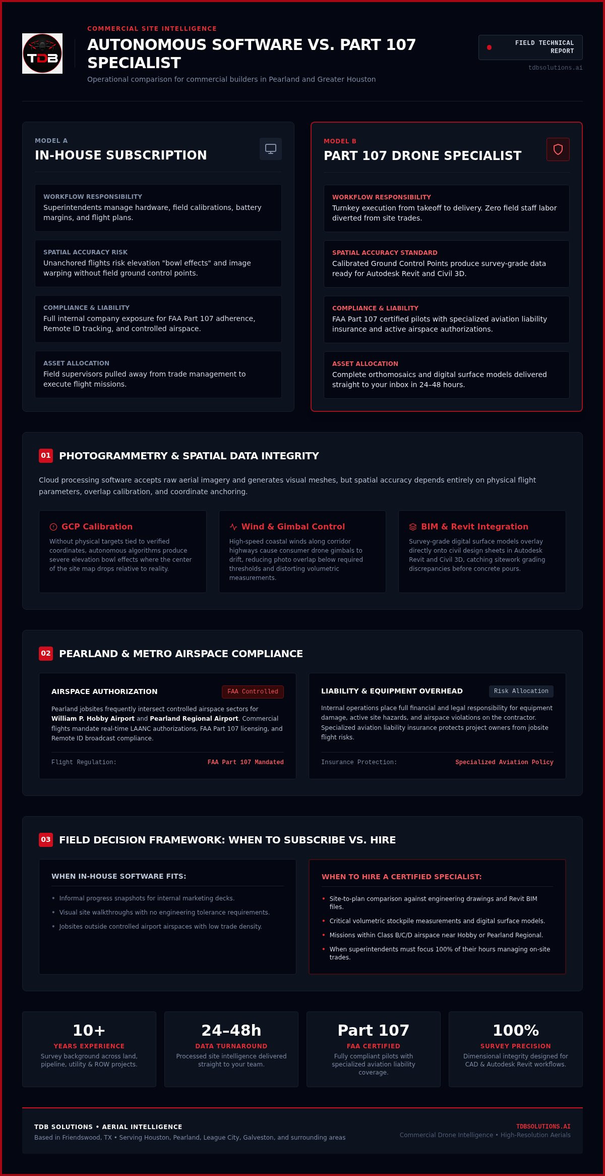
Framework: When to Subscribe vs Hire Local Specialists
Deciding between software platforms and outsourced flight services comes down to your internal bandwidth. When weighing DroneDeploy vs hiring a Part 107 drone service provider Pearland developers must look honestly at personnel capacity. Managing hardware in-house requires continuous training and pilot retention. If your certified employee leaves the company, your flight program halts immediately, leaving you with recurring software costs and idle airframes.
Use this evaluation matrix to assess your team's operational readiness:
- Staffing consistency: Do you employ dedicated pilots, or are you forcing project managers to juggle commercial aviation duties?
- Turnaround windows: Can your team process and review imagery within 24 to 48 hours without neglecting superintendent responsibilities?
- Data stakes: Are you taking casual overhead photos, or do you require survey-grade data for structural verification?
- Regulatory tracking: Can your team actively manage FAADroneZone records and monitor recurrent certification cycles?
Scenarios Where Software-Only Subscriptions Make Sense
In-house processing tools work well when your organization maintains dedicated aviation personnel. If your company already employs full-time, certified pilots who handle fleet logistics, adding a cloud interface makes sense. This model fits broad, multi-region builders capturing basic site records where dimensional precision is secondary to quick visual overviews.
Scenarios Demanding an External Part 107 Service Provider
Complex civil projects and active commercial builds demand dedicated field partners. When contractors need tight site-to-plan comparison or verified earthwork tracking, delegating to specialists protects project milestones. Working with an outside provider delivers reliable site intelligence within 24 hours of flight completion without equipment depreciation or pilot turnover headaches.
Understanding the balance in DroneDeploy vs hiring a Part 107 drone service provider Pearland projects need prevents wasted labor. If you want turnkey commercial aerial intelligence without hardware investments or compliance liabilities, partner with TDB Solutions today.
Why Pearland Builders Rely on TDB Solutions for Aerial Intelligence
When resolving the debate between DroneDeploy vs hiring a Part 107 drone service provider Pearland commercial builders look for boots-on-the-ground execution rather than remote software help desks. Based locally in Friendswood, TDB Solutions delivers construction intelligence, aerial photography, and aerial inspection services across Pearland, Houston, League City, and Galveston. You get direct access to local professionals who understand Southeast Texas site conditions, high-wind coastal fronts, and regional airspace corridors.
Managing an internal drone workflow exposes your business to pilot turnover, hardware depreciation, and federal airspace violations. Choosing TDB Solutions replaces that operational friction with a reliable, certified field partner. You secure timely site documentation without diverting your superintendents from managing active jobsite trades.
Survey-Grade Background Applied to Construction Tracking
Reliable spatial data requires a disciplined field approach. Founder Dillon Bates brings over 10 years of survey experience across land, pipeline, utility, and right-of-way infrastructure projects. That technical background ensures that every digital surface model, volumetric report, and orthomosaic map aligns with strict construction requirements.
While we do not perform licensed land surveying, our team applies professional survey precision to aerial documentation. That means your site managers receive survey-grade data ready for site-to-plan comparison without worrying about spatial drift, skewed elevation scales, or uncalibrated camera sensors.
Fast Field Execution Across Greater Houston
Project delays cost money. Waiting days for internal staff to upload, process, and troubleshoot raw aerial files holds up trade scheduling and subcontractor coordination. TDB Solutions solves that bottleneck with disciplined flight operations and dependable turnaround pipelines.
Every mission is flown by FAA Part 107 certified pilots backed by specialized aviation liability insurance. Deliverables arrive within 24 to 48 hours of flight completion, with most standard site shoots delivered within 24 hours. You receive clean, high-resolution photos and actionable site intelligence formatted for immediate project stakeholder review.
Take the risk, liability, and hardware overhead off your project trailer. Contact TDB Solutions today to schedule your commercial flight operations in Pearland.
Make the Confident Call for Your Pearland Jobsite
Resolving the choice between DroneDeploy vs hiring a Part 107 drone service provider Pearland projects require comes down to risk, accuracy, and team productivity. Software subscriptions leave flight planning, hardware maintenance, and complex airspace authorizations in your hands. Working with a dedicated specialist eliminates those distractions so your superintendents can focus on running trades.
TDB Solutions brings over 10 years of professional survey experience applied to aerial intelligence, ensuring reliable spatial precision on every site-to-plan overlay. Our missions are operated by FAA Part 107 certified pilots with specialized aviation liability insurance, protecting your schedule and balance sheet against jobsite risk. Fast data delivery within 24 to 48 hours of flight completion keeps your project stakeholders informed without delays.
Stop wrestling with flight logs and uncalibrated models. Protect your build schedule, eliminate compliance stress, and secure reliable progress tracking today. Schedule your Pearland site flight with TDB Solutions to put dependable aerial intelligence to work on your next project.
Frequently Asked Questions
Can anyone at our Pearland construction firm fly a drone for jobsite updates?
No. Any drone flight conducted in furtherance of a commercial business requires an active FAA Part 107 remote pilot certificate. Operating without one violates federal law and exposes your company to civil fines. The aircraft must also comply with Part 89 Remote ID mandates. When analyzing DroneDeploy vs hiring a Part 107 drone service provider Pearland contractors should recognize that buying software does not grant staff legal permission to fly.
Is mapping software alone enough to create accurate site-to-plan comparison models?
Software processes pixels, but it cannot calibrate field accuracy on its own. Reliable site-to-plan comparison models require physical ground control points and checkpoints tied to known site benchmarks. Without ground reference data, cloud photogrammetry software produces warped elevation layers and distorted horizontal measurements. You need disciplined field survey principles during data capture to ensure processed digital surface models line up with engineered plans.
What airspace hurdles impact commercial drone flights across Pearland, Texas?
Pearland sits under controlled airspace boundaries. Northern developments fall beneath William P. Hobby Airport's tiered Class B airspace, requiring automated LAANC authorization or FAA waivers before launch. Eastern sectors share low-altitude airspace with general aviation traffic from Pearland Regional Airport. Professional operators actively manage airspace clearances, monitor visual traffic, and ensure compliant Remote ID broadcasting to prevent operations from encroaching on restricted flight paths.
How fast does an outsourced drone service provider deliver processed project data?
Turnaround speed depends on project scope, but a dedicated provider delivers much faster than backlogged internal teams. TDB Solutions delivers standard flight media and inspection packages within 24 hours of landing. Complex orthomosaic processing and volumetric datasets are completed within 24 to 48 hours. This predictable timeline keeps your superintendents informed without pulling field staff away from jobsite management duties.
Do construction companies need specialized aviation insurance if an employee flies?
Yes. Standard commercial general liability policies almost universally exclude unmanned aircraft operations. If an employee damages heavy machinery, drops an aircraft on a vehicle, or causes a jobsite injury, your general policy will not cover the loss. In the debate of DroneDeploy vs hiring a Part 107 drone service provider Pearland builders avoid this exposure by hiring certified specialists who carry dedicated aviation liability insurance on every mission.
Can drone service providers export data compatible with Autodesk Revit?
Yes. Professional aerial intelligence workflows generate files formatted directly for Autodesk Revit, Civil 3D, and Autodesk Build. Providers deliver georeferenced orthomosaic TIFF files, digital surface models, and 3D point clouds that plug straight into your BIM environment. This enables seamless CAD overlays and early rework detection without forcing your engineers to manually reformat raw drone captures.


