

What if aerial evidence strengthened your Galveston bid by making its assumptions easier to understand? Aerial construction progress tracking Galveston contractors can use puts site conditions, access points, and proposed work into context when written notes and ground-level photos leave questions unanswered.
Clear documentation helps show what exists now, what your estimate assumes, and how the work may unfold. The key is to describe what aerial images show without overstating what they prove. A repeatable capture plan can make your bid easier to review while keeping visual records distinct from survey deliverables.
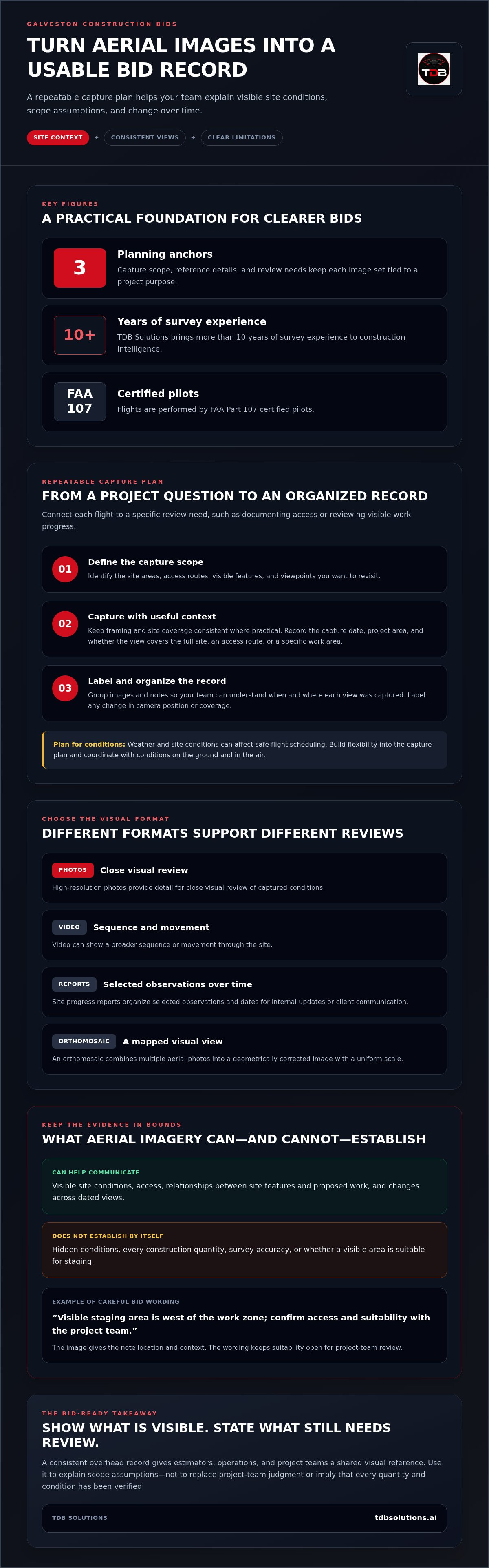
This article explains how to plan aerial progress tracking before submitting a bid, choose views that support your scope, and organize records to show visible changes over time. You’ll also learn where aerial documentation has limits, so your bid stays grounded in appropriate evidence. TDB Solutions brings more than 10 years of survey experience to construction intelligence, with flights performed by FAA Part 107 certified pilots.
Key Takeaways
- Use overhead views to add site context that notes and ground-level photos may miss, particularly around access and visible constraints.
- Plan aerial construction progress tracking Galveston bids around a specific question, defined site coverage, consistent capture, organized records, and review.
- An orthomosaic combines multiple aerial photos into a geometrically corrected image, giving your team a useful site view while keeping its limits clear.
- Aerial imagery can help explain scope assumptions, but it can’t guarantee a contract award or verify every quantity and project assumption.
- TDB Solutions’ construction intelligence can document visible site conditions and changes over time to support clearer project communication.
Why Galveston construction bids need clear site documentation
A carefully priced bid can still be difficult to evaluate if its site assumptions are unclear. A note may describe a narrow entrance or limited staging space, but it may not show how that condition relates to the work area. Ground-level photos help, though each frame captures only part of the scene. Aerial construction progress tracking Galveston contractors can use adds an overhead perspective, helping reviewers see the relationship between access, visible site features, and proposed work.
That context can matter on Galveston Island, where a site may be near waterfront areas, local roads, neighboring properties, or other visible constraints. An overhead view can orient a reader before they assess the written scope. It can also give estimating, operations, and project teams a shared reference for discussing the site. For general background on the method, aerial photography in construction draws on the broader practice of capturing and interpreting images from above.
Which site details are difficult to communicate in a bid?
Access routes, potential laydown areas, visible boundaries, and nearby features can be hard to explain with isolated photos. An aerial image can place several of those details in one frame, but it should not turn a visual observation into an unverified project fact. Label what the image shows, then separate that observation from conditions the project team still needs to review.
For example, a plan note might read: “Visible staging area is west of the work zone; confirm access and suitability with the project team.” The image gives the note location and context. The wording makes clear that the visible area has not automatically been approved for staging.
What aerial progress tracking adds before work begins
A dated overhead view creates a visual reference for preconstruction discussions. Teams can return to it when reviewing how the site looked at a particular stage, comparing it with later documentation, or discussing how proposed work relates to visible conditions. Keep the capture perspective and site coverage consistent where practical. That makes changes easier to interpret and reduces the chance that a different camera angle or frame gets mistaken for a site change.
Aerial progress tracking is the regular capture and organization of overhead site images to document visible conditions and changes over time. Before work begins, that record can help estimators and project teams discuss scope and sequencing using a shared visual reference. It supports communication, but it doesn’t establish every quantity, confirm hidden conditions, or replace project-team judgment.
Clearer evidence can make bid assumptions easier to explain and review, but it can’t guarantee a contract award or profit. Use aerial views to show what’s visible, state what still needs validation, and give decision-makers a clearer picture of the site behind your proposed work.
How aerial construction progress tracking creates a usable project record
A useful aerial record starts with a plan. Define the areas to capture, choose viewpoints that can be repeated, and connect each flight to a project question, such as documenting site access or reviewing visible work progress. After capture, label the images and notes clearly and organize them in a format your team can review. This turns separate flights into a record of the project over time rather than a folder of disconnected pictures.
For aerial construction progress tracking Galveston projects, consistency helps reviewers understand when and where each view was captured. It also makes changes easier to interpret. Weather and site conditions can affect safe flight scheduling, so build flexibility into the capture plan and coordinate the record with conditions on the ground and in the air.
What a repeatable aerial capture plan includes
Identify the project areas and viewpoints you want to revisit. With each image set, record the capture date and useful project context, such as whether the view covers the full site, an access route, or a specific work area. If the camera position or coverage changes, label that difference. Consistent framing helps reviewers compare image sets without mistaking a changed viewpoint for a change on site.
- Capture scope: Identify the site areas and visible features relevant to progress review.
- Reference details: Keep the date, project area, and useful context with each image set.
- Review needs: Decide whether the team needs photos, video, a progress report, or another visual format.
How teams can use the visual record
High-resolution photos provide detail for close visual review. Video can show a broader sequence or movement through the site. Site progress reports organize selected observations and dates for internal updates or client communication. Measurements are a separate consideration: imagery may support certain measurement workflows, but the method and accuracy of the deliverable must suit its intended use. Don’t treat a visual estimate as a verified quantity.
An orthomosaic is a geometrically corrected aerial image composed of multiple photos, giving the combined image a uniform scale. An orthomosaic provides a mapped visual view of the captured site, but it doesn’t by itself prove hidden conditions, construction quantities, or survey accuracy. Keep that distinction clear when teams use imagery to discuss progress or compare visible features.
With dated image sets, project managers can review what changed between captures, flag areas for follow-up, and prepare clearer client updates. TDB Solutions’ construction intelligence and drone data helps organize aerial documentation into a practical project record for review.
Can aerial tracking help you win more profitable construction bids in Galveston?
Aerial tracking can help you explain a bid more clearly, but imagery can’t ensure a contract award or make a project profitable. Its value is the visual context it adds to your proposal’s assumptions. Your team still needs to validate quantities, labor, access, schedule, and other project assumptions using the appropriate project documents and review.
For a Galveston bid, a dated overhead view might show the visible approach to a work area, nearby structures, or how a proposed staging zone relates to the site. Pair the image with a note identifying what you observed and what you assumed. This helps an estimator, owner, or project manager follow the connection between site context and proposed scope without asking the image to prove more than it can.
Where aerial evidence can strengthen a bid
Use aerial views to clarify visible access, existing site conditions, and proposed work areas. A marked-up image can help your team discuss which areas relate to the scope and how work might be sequenced. For example, an overhead view may help explain why your plan separates activity near an entrance from work farther inside the site. The image supports that discussion; contract documents and written scope still define the work.
Dated documentation also makes a bid narrative easier to follow. A reviewer can connect an observation to a specific view and date, then compare that context with your written assumption. State what the image shows, what it suggests, and what still needs confirmation. Clear labeling helps prevent a visual reference from being mistaken for a contractual commitment.
Where aerial imagery has limits
An aerial image records visible conditions at the time of capture. It can’t show every buried utility, concealed condition, access restriction, or detail outside the camera’s view. An image alone also doesn’t verify quantities, legal boundaries, or construction compliance. Don’t use visual context as a substitute for contract documents, required technical deliverables, or professional judgment.
Define your assumptions in writing. State which quantities rely on project information, which visible conditions informed your approach, and which items need review before work proceeds. Clarify the deliverable’s purpose too: a photo record, progress report, and measurement output serve different needs. Match the requested output to the decision your team needs to make.
If tracking feels like extra work, tie each capture to a specific question: “Can the team review the visible access route?” or “What changed in this work area since the previous record?” Skip views that don’t help answer a project question. That discipline makes aerial construction progress tracking Galveston teams can use more purposeful and keeps unrelated material out of the bid package.
TDB Solutions provides construction intelligence and aerial progress tracking for Galveston-area projects. To connect visual documentation to practical bid and project communication, explore construction intelligence services.
How to build Galveston aerial tracking into your construction bid plan
Make aerial documentation answer a bid question, not just add images to a folder. A focused plan helps you decide what the team needs to see, which parts of the site matter, and how the record will support your proposal. For aerial construction progress tracking Galveston projects, tailor coverage to visible access, waterfront context, work areas, and surrounding constraints that affect the bid.
Use this five-step workflow to connect the capture to your bid:
- Define the bid question. Identify the decision the imagery should inform, such as how visible access relates to a proposed work area.
- Set the site scope. Mark relevant work zones, entrances, nearby features, and viewpoints that will help explain the planned work.
- Capture the agreed areas. Use the project brief to guide coverage. Keep the image set focused on the question rather than collecting views with no clear purpose.
- Organize the record. Keep dates, image labels, project context, and related bid references together so reviewers can follow each item.
- Review before submission. Check that each selected view supports a stated assumption, and flag details that still need project-team validation.
Create a bid-focused aerial capture brief
Write down the decisions first, then define the flight coverage. Identify which areas, access points, and viewpoints will help answer those questions. For a waterfront-adjacent site, include the visible relationship between the work zone and shoreline-side features when that context affects the bid. Name who will review the imagery and which bid documents or assumptions it should inform.
A concise brief keeps the record useful after capture. It gives each view a reason and gives reviewers a clear reference for discussing scope, without suggesting that imagery replaces contract documents or confirms conditions that cannot be seen.
Turn the captured record into clear bid communication
Choose views that help explain your proposal. Give each one a short caption, capture date, and reference to the related bid assumption. For instance: “North access visible in the image; proposed delivery route remains subject to project-team review.” This format separates what the image shows from your estimate or interpretation.
Keep the notes and images in a reviewable package. An estimator can trace a visual reference to the relevant scope language, while operations staff can identify open questions before submission. Don’t label a visible feature as an approved route or confirmed staging area unless the project team has established that in the bid documents.
For a Galveston project, TDB Solutions can plan aerial documentation around the site questions your bid needs to address. Plan a project-specific aerial capture to connect site views with clear, reviewable bid communication.
Plan aerial construction progress tracking in Galveston with TDB Solutions
TDB Solutions provides construction intelligence and aerial progress tracking for Galveston and surrounding communities, including Houston, Friendswood, Pearland, and League City. The goal is practical visual documentation that helps your team review site conditions and communicate project changes. TDB Solutions’ flights are performed by FAA Part 107 certified pilots and include liability insurance.
Choose deliverables based on the decisions your team needs to make. Aerial documentation and overhead views provide context across a site. Site progress reports organize observations for project discussions, while volumetric measurements address a distinct measurement need and should match the intended use. Each output should have a clear purpose and support, not replace, professional judgment.
What TDB Solutions brings to a construction project
Construction documentation can include regular aerial records, site progress reports, volumetric measurements, and overhead oversight. The right mix depends on what you need to review and communicate. A progress report, for example, can focus a discussion on selected site observations, while overhead views provide broader context around work areas.
Deliverables are typically available within 24-48 hours of the flight. Your team can use the materials to keep project discussions moving, with dates and site context attached to support review. Clear organization helps readers understand what each item covers and how it relates to the project.
Start with the bid question and the site
Identify which site conditions or bid assumptions need clearer documentation. Is your team reviewing an access point, the relationship between a work zone and nearby features, or a particular area before work begins? A defined question helps shape the capture scope and keeps the resulting record relevant to the project stage and intended review.
Then identify who will use the documentation and what decision it should inform. Keep visual observations distinct from items that need confirmation through project records or team review. This gives the capture a clear role in your workflow without overstating what aerial views can establish.
Discuss your project’s documentation needs with TDB Solutions. Discuss your Galveston aerial tracking plan and identify the site views and records that can support clear project communication.
Make your next project record work harder
Turn one open site question into a clear documentation brief. Identify the decision your team needs to make, the areas that matter, and who will review the resulting images. That focus keeps aerial construction progress tracking Galveston tied to real project needs instead of producing visuals without a defined purpose.
Keep the record practical. Connect each view to a date, a site area, and a written assumption or review question. As the project moves forward, that structure gives your team a consistent reference for discussing changes and communicating with stakeholders. It also helps everyone distinguish visible evidence from items that still need confirmation through project documents or professional review.
Every jobsite has its own access conditions, work sequence, and documentation priorities. Build your capture plan around those needs. Discuss aerial construction progress tracking for your Galveston project with TDB Solutions and map out an approach suited to your site. Start with the question you need answered, then create a clear visual record around it.
Frequently Asked Questions
Can aerial construction progress tracking help make a bid more competitive?
It can make a bid package easier to review when the solicitation allows visual supporting material. Check the bid instructions first, then include only images that help explain a specific work package or proposed sequence. Label each exhibit so reviewers can connect it to the relevant bid section without searching through unrelated files. Aerial documentation supports your submission; it doesn’t replace required forms, specifications, or contract documents.
How quickly are TDB Solutions’ aerial deliverables available?
TDB Solutions’ deliverables are typically available within 24-48 hours of the flight. Allow additional time for flight scheduling and your team’s review. For a deadline-sensitive bid, set an internal cutoff for receiving and reviewing the materials before the final package is due. This gives your team time to select relevant files, check captions, and remove items that don’t belong in the submission. Share key bid dates during project planning.
What happens if weather delays a planned drone flight?
If weather moves a planned flight, update the bid team’s document schedule and mark any aerial exhibit that still needs capture. Decide which decisions can proceed using current bid documents and which depend on new imagery. That keeps a pending visual record from appearing complete in a draft package. Once the project team sets a revised capture date, adjust the review deadline as well.
Can aerial documentation help coordinate subcontractors?
Yes. During a coordination meeting, use an aerial view to orient trade partners, then record each assigned action in the meeting notes with an owner and due date. For example, a discussion about a shared work zone can end with clear responsibilities for access sequencing. Keep the current plan set as the controlling reference, and note which plan sheet supports each coordination decision.
Does an aerial progress record show conditions that cannot be seen from above?
No. An overhead record can’t provide a complete account of concealed or obstructed areas. To make its coverage clear, maintain an index of the areas included in each image set and note locations the capture didn’t cover. Your team can then identify open documentation needs and connect them to appropriate project records or follow-up observations before relying on the package for a decision.
Can I use aerial tracking before construction begins?
Yes. Before mobilization, use aerial construction progress tracking to organize a visual index by work area or trade package. That index can give the kickoff meeting a practical starting point for assigning who will review updates and how teams will share them. Define those responsibilities early so project communication has a clear owner as work moves from bid planning into active construction.


