

What should a property video help buyers understand? Often, it’s not just the home itself, but how the lot, landscaping, waterfront access, and surrounding area fit together. That’s where drone video real estate Texas agents can use becomes useful: aerial footage adds context to the ground-level story of a listing.
To plan a shoot, decide which property details buyers need to see, coordinate access, and choose where you’ll use the finished media. This guide covers when aerial video adds value, how to prepare for filming, and what to expect from a Houston-area media partner. TDB Solutions serves Houston, Friendswood, Pearland, Galveston, and League City. FAA Part 107 certified pilots with more than 10 years of survey experience produce real estate media, and most shoots are delivered within 24 hours. Here’s how to plan a focused shoot and create useful listing content.
Key Takeaways
- Use aerial footage to explain a property’s layout, setting, and features that are hard to see from the ground.
- Give viewers a clear visual path by starting with a wide view, then moving to closer aerial angles.
- Choose aerial photography for quick visual references and drone video when movement helps explain how features relate.
- Plan your drone video real estate Texas shoot by defining the listing story, selecting priority views, coordinating access, and deciding how you’ll use the footage.
- Look for a media team with relevant aerial experience and FAA Part 107 certification.
What Drone Video Adds to a Texas Real Estate Listing
A useful drone video real estate Texas listing begins with a practical question: what can buyers understand from above that ground-level photos don’t show? Moving aerial footage can communicate a property’s setting and layout. Overhead views show how buildings, open areas, landscaping, and outdoor features relate to one another. Angled views add perspective and help viewers connect the property to its surroundings.
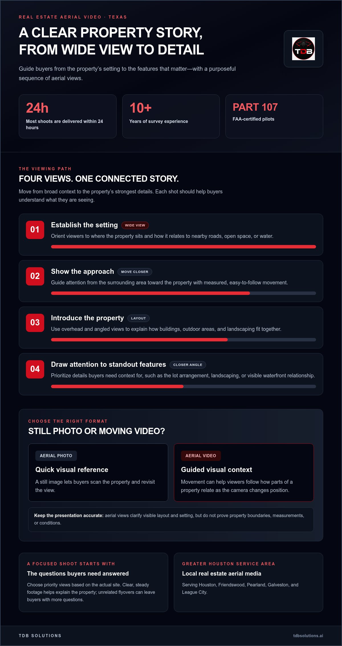
Aerial photography and aerial video serve different purposes. A still photo gives buyers a quick visual reference, while video uses movement to guide their attention across a property and its setting. Both are forms of aerial photography and videography, but the right format depends on the story your listing needs to tell.
The goal isn’t simply to capture dramatic footage. Each view should help buyers interpret what’s actually there. Aerial angles can clarify visible layout, but they shouldn’t suggest features, access, or boundaries the property doesn’t have. Accurate presentation gives buyers a clearer picture. Unrelated flyovers can leave them with more questions than answers.
Which property details benefit from an aerial view?
Consider what’s difficult to understand from the ground. An aerial view can show the scale and arrangement of a lot, the placement of landscaping, and the property’s position in relation to nearby roads or open space. For a waterfront listing, footage may help communicate the visible relationship between the property and the water. The right views depend on the site and the details you want buyers to notice.
Useful context answers likely buyer questions: How is the outdoor space arranged? Where does the property sit within its surroundings? Dramatic motion alone won’t answer them. Prioritize clear, steady views that explain the setting, then use ground-level media to show details aerial footage can’t communicate well.
When does aerial video make sense for a listing?
Different properties need different visual stories. For a home, aerial video might connect the building, yard, landscaping, and nearby setting. For vacant land, the emphasis may be the visible shape and surrounding context, without implying a surveyed boundary. A commercial property may need views that explain how its buildings and outdoor areas fit together. Let the site’s actual layout guide the shot priorities.
Not every listing needs aerial video. It makes sense when an aerial perspective helps buyers understand a feature or relationship that ground-level images leave unclear. Before planning a shoot, identify the questions the footage should answer. That focus keeps the video informative and ensures aerial views support the property’s story rather than distract from it.
How Real Estate Drone Video Builds a Clear Property Story
A useful aerial edit gives viewers a path through the property rather than a collection of unrelated flyovers. Start with the setting, move toward the approach, introduce the property, then draw attention to standout features. This sequence helps prospective buyers understand where the property sits before they focus on what makes it distinct.
Purposeful shot order turns aerial footage into a guided view of the property, connecting its setting to the features buyers came to see. A wide establishing view orients viewers first. Closer aerial angles add detail, while measured transitions keep the video easy to follow.
Plan aerial shots around the property's strongest features
Choose priorities before filming. Depending on the property, those may include the lot’s arrangement, landscaping, waterfront access, or another feature that gives buyers useful context. A wide view can establish the overall scene. A closer angle can draw attention to a relevant feature while showing how it relates to the rest of the property.
Keep movement deliberate. A sequence that shifts from a broad view to a closer one feels easier to follow than abrupt changes between unrelated angles. Aerial footage communicates visible context, but it doesn’t prove boundaries, measurements, or property conditions. For guidance on responsible use in real estate, see the National Association of REALTORS® on drone use.
Match the edit to the intended audience and channel
A listing-focused edit can give prospective buyers a connected view of the setting and property. A shorter social media or advertising cut can focus on a standout feature and direct viewers toward the full listing. On a property website, video can provide visual context that helps visitors understand the location and layout before arranging a closer look.
Professional High-Performance Video Production means shaping footage around its purpose, not simply adding effects. Consider where buyers will watch and what they need to understand. A concise edit can work well for a social post. A fuller sequence gives a listing page room to establish context and explore key views.
For drone video real estate Texas listings, keep the story accurate from filming through editing. Don’t use camera movement or editing to imply access, boundaries, or features the property doesn’t have. A clear shot plan aligns the footage with the actual site and your audience’s needs. If you’re planning a listing video, explore real estate media planning with TDB Solutions.
Does Drone Video Add More Than Aerial Photos?
Drone video and aerial photos answer different questions. A still image gives buyers a quick reference they can scan and revisit. Moving footage adds direction, helping viewers follow how parts of a property relate as the camera changes position. Ground-level images show details such as room finishes and entrances from a closer perspective.
Video isn’t automatically more informative. Aerial footage alone can’t tell a property’s full story, and motion without a clear purpose may leave buyers unsure what they’re seeing. Choose each format for the information it communicates, then pair it with other listing media when that fills a real gap.
Media format | Question it helps answer
- Aerial photography: What does the layout or setting look like from above?
- Drone video: How do visible features relate as the view moves across the property?
- Ground-level images: What do the home’s exterior details and nearby features look like up close?
Choose the format that fits the property
Use aerial photography when buyers need a clear, still view of the lot, landscaping, or surrounding setting. Use video when movement can explain scale, a visible approach, or the relationship between features. For example, a sequence that moves from a broad view toward an outdoor feature can connect the feature to the property as a whole.
Combine formats only when each has a distinct job. Aerial photos work as easy-to-scan references, while video guides the viewer through a visual sequence. Ground-level images fill in details an overhead view can’t show. This keeps the listing useful without making buyers sort through duplicate material.
Choose deliverables based on where buyers will see them
Plan the edit around the viewing channel. A website video can give prospective buyers more time to take in the property’s context. A social media cut may focus on one or two key views so the central point comes through quickly. An advertising version can be shaped for its placement and audience, with a clear link or direction to the full listing where appropriate.
Short variants let you adapt footage for different placements, but each edit should keep accurate context and a clear purpose. Don’t assume one version suits every channel. Decide where you’ll use the media before production, then match its length and emphasis to that use. For broader planning around drone video real estate Texas listings, see Houston real estate drone services.
Plan a Texas Real Estate Drone Video Shoot
A focused shoot starts before the drone takes off. Decide what the listing needs to communicate, identify the views that support that story, coordinate property access, and agree on how you’ll use the finished media. This gives the shoot a clear purpose and helps everyone prepare around the same priorities.
Share the essentials early: “Before the property shoot, send the address, access details, key features to capture, preferred views, and intended media uses.” Those details help shape the shot plan. Flight timing depends on conditions and project coordination, so keep scheduling flexible rather than assuming the drone can fly at a particular moment.
Prepare the property and clarify the shot priorities
Start with a short list of the features you want buyers to notice. You might prioritize the property’s overall layout, landscaping, waterfront access, or the way buildings sit within the lot. Note the views that could help explain the setting, along with areas the video should avoid emphasizing.
Coordinate access and on-site scheduling before the shoot. Confirm how the pilot will reach the property and who will be available to provide access. Staging and ground-level preparation are separate tasks, so arrange those as needed for the listing. Clear priorities keep the flight focused on the views that matter.
Coordinate local coverage and delivery expectations
TDB Solutions serves Houston and nearby communities, including Friendswood, Pearland, Galveston, and League City. Share the property’s location and your schedule early so the shoot can be coordinated around the site and project needs. Local coverage can simplify planning across Greater Houston, but flight timing still depends on conditions and coordination.
Most shoots are delivered within 24 hours. That’s a typical turnaround, not a guarantee for every project. Agree on the intended deliverables and when you need them for the listing, website, social media, or advertising. Clear expectations help you plan publication without treating a typical timeline as a fixed deadline.
For drone video real estate Texas listings, keep the process straightforward: define the story, name the priorities, arrange access, and plan how you’ll use the finished footage. When you’re ready to organize aerial media for a property in the Houston area, plan your real estate drone video shoot with TDB Solutions.
Choose TDB Solutions for Real Estate Drone Video in Greater Houston
TDB Solutions is based in Friendswood and produces real estate media for Houston and nearby communities, including Pearland, Galveston, and League City. FAA Part 107 certified pilots with full liability insurance perform every flight. That local coverage and professional preparation give you a clear starting point for planning an aerial shoot around the property and its listing needs.
Share the property location and the features you want buyers to understand. Contact TDB Solutions to discuss real estate drone video for your Greater Houston listing.
What TDB Solutions brings to a property media project
TDB Solutions creates real estate media that can include aerial photography and video. The team plans views around the listing’s setting and priorities, giving the footage a clear role in the property presentation. Founder Dillon Bates brings more than 10 years of survey experience to aerial planning, with attention to site layout and useful viewpoints. That background does not make the media a land survey or establish property boundaries.
Technical aerial deliverables are typically available within 24-48 hours of the flight. Plan how the finished media will fit into your listing materials, while keeping in mind that timing relates to the flight and project coordination.
Good property media starts with a practical conversation. Tell us where the property is, which details matter most to your listing, and where you plan to use the footage. That helps align the aerial plan with the property’s actual features and the audience you want to reach.
Take the next step for a Houston-area property
If you need broader video-production ideas for a business or campaign, explore marketing video production in Houston. For a property listing, keep the brief focused: identify the location, priority views, access details, and intended use for the final media. Clear information helps organize the shoot from planning through delivery.
Whether your listing is in Houston, Friendswood, Pearland, Galveston, or League City, TDB Solutions can shape an aerial media plan around its setting and standout features. Contact TDB Solutions with your property location and listing priorities to get the conversation started.
Make Your Next Listing More Intentional
Your next listing is an opportunity to decide not only what buyers see, but what they should remember. Before production begins, connect the visual plan to the property’s positioning: the audience you want to reach, the questions they may have, and the impression you want the listing to leave. This gives each creative choice a job and helps keep the presentation consistent wherever prospective buyers encounter it.
A focused drone video real estate Texas plan makes aerial media part of your broader listing workflow rather than a standalone clip. If several people contribute to the listing, agree on one central message before production. Then set a review point for the finished video and coordinate its placement with the rest of your listing materials. These decisions help keep the presentation clear and aligned.
Ready to plan your property’s next media step? Contact TDB Solutions to plan real estate drone video for your property. Bring your listing goals and property details to start with a focused creative plan.
Frequently Asked Questions
Can drone video help market vacant land?
Yes. Aerial footage can help market vacant land by showing its visible layout, vegetation, access points, and nearby context. For example, a sequence can orient viewers to an entrance, then show how open ground or tree cover sits across the site. This gives buyers a visual overview, but it doesn’t establish parcel lines or replace surveying. Before the shoot, list the features buyers need to understand so the footage can focus on useful views.
Is drone video useful for commercial real estate?
Yes. Drone video can help viewers understand a commercial property’s site layout, visible access, and surroundings. A business site might need a broad view that relates its buildings to parking areas, while another property may call for footage that emphasizes its setting. Choose shots based on the intended audience and the site’s relevant features. Marketing media presents visible context, not an inspection, measurement, or survey.
Can real estate drone video show waterfront access?
Yes. Aerial views can communicate a property’s visible relationship to waterfront features when that context matters to buyers. A view may show how the property sits beside a shoreline or where visible paths approach the water. Footage doesn’t verify access rights, property boundaries, or water conditions. Before filming, identify the waterfront details buyers should see so the planned views explain the property’s context rather than focusing on scenery alone.
How quickly can I receive real estate drone footage?
Most TDB Solutions shoots are delivered within 24 hours. Technical aerial deliverables are typically available within 24-48 hours after the flight. These are typical timeframes, not guarantees for every project. Timing depends on the deliverable and project details, so include your intended use and listing schedule when coordinating the shoot. Planning media needs early can help you coordinate the flight and next steps for using the footage.
Can I use real estate drone video on my website and social media?
Yes. TDB Solutions produces video content for websites, social media, and advertising. For drone video real estate Texas campaigns, plan each edit around its placement and audience. A website may need footage that gives visitors more context, while a social post may call for a shorter cut focused on one property detail. Share the channels you plan to use when describing the project. Platform acceptance and audience response aren’t guaranteed.
Do drone videos show property boundaries accurately?
No. Marketing footage can show visible features and surrounding context, but it shouldn’t be presented as a boundary survey. Camera perspective can change how distances and angles appear, and visible markers don’t establish legal parcel lines. TDB Solutions provides aerial media and technical drone services, not licensed land surveying. Use video to help viewers understand what they can see, not to define ownership limits or confirm a parcel’s measured boundaries.


