

Commercial drone inspection without scaffolding gives you high-resolution spatial and thermal data across complex structures without plant shutdowns or foot-traffic closures. Eliminate physical staging and you cut structural review costs by up to 80% while removing slip-and-fall hazards for maintenance crews; the high setup expenses attached to small commercial sites come from scaffolding assembly and short equipment rental, not from the flight alternative. Industrial operators across the Greater Houston metro now use unmanned flights to evaluate elevated infrastructure safely. The decision questions that run through this guide are simple: which access method fits your footprint, when remote flight data beats towers, and where you still need hands-on testing.
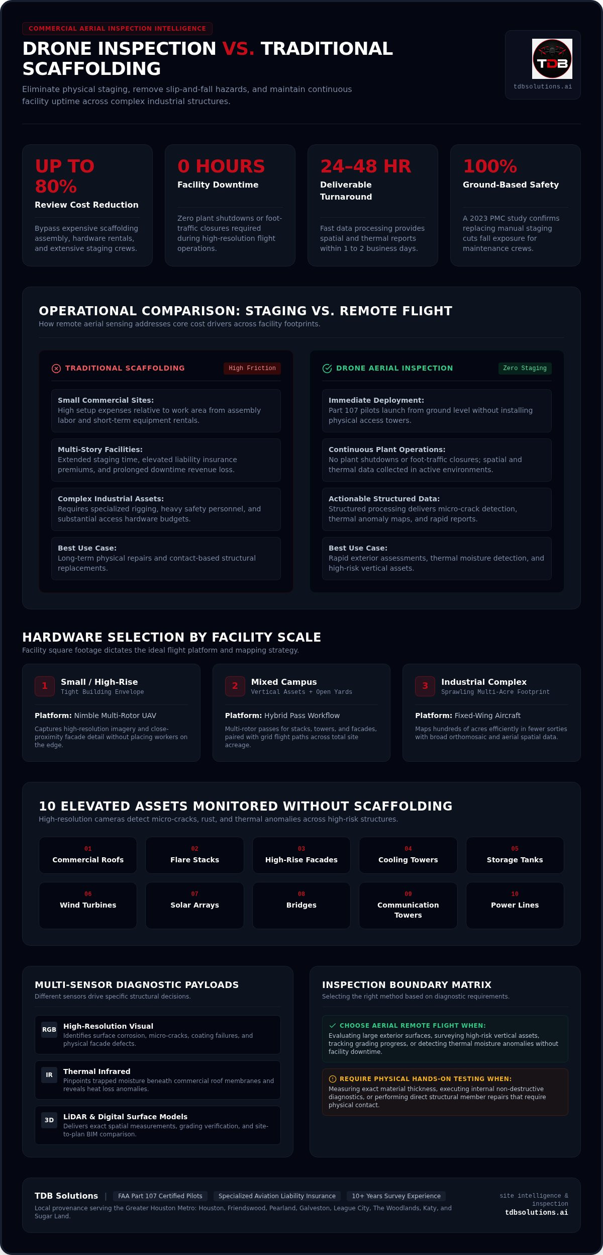
Key Takeaways: Drone inspection without scaffolding eliminates physical staging to reduce structural review costs by up to 80% while maintaining full facility uptime.
- Market pricing for commercial aerial projects typically ranges from $3,000 to $25,000 depending on facility size.
- Skip it when you require material thickness measurements or internal diagnostics that necessitate physical contact.
- Aerial monitoring is best for rapid exterior assessments, thermal moisture detection, and high-risk vertical assets.
- A 2023 PMC study confirms that replacing manual scaffolding with unmanned systems significantly cuts fall exposure.
Match flight hardware to your facility scale
Facility square footage sets your ideal flight setup for a drone roof inspection (aerial inspection). Before you book a crew, match your site to a concrete recommendation drawn from how these flights actually run:
- Small commercial rooftop or tight high-rise envelope: use a nimble multi-rotor so you capture high-resolution imagery without putting people on the edge.
- Sprawling industrial complex: choose a fixed-wing platform that maps hundreds of acres efficiently in fewer sorties.
- Mixed campus (vertical assets plus open yards): plan multi-rotor passes for stacks and facades, then grid flights for the acreage.
Size dictates hardware selection. Selecting the right drone mapping approach depends directly on your total site footprint.
We provide precise drone services tailored to your exact square footage. Based in Houston, TX, we serve the greater Houston metro and surrounding areas. For general site photos (construction intelligence), structured processing delivers actionable data rather than raw visual files; drone monitoring is not a photography service.
Tip: Deploy multi-rotor UAVs for tight high-rise envelopes and fixed-wing units for sprawling industrial footprints.
Drone vs scaffolding cost: exact ROI calculations
If scaffolding line items keep bloating your inspection budget, the ROI math below shows where unmanned flights pull those costs back.
You bypass traditional access costs when drone-based inspections remove heavy hardware rentals and shrink labor hours. Scaffolding requires days of manual installation, high liability insurance premiums, and extended facility downtime. A drone roof inspection returns value faster because you skip that build cycle.
Market research places commercial aerial project pricing from $3,000 to $25,000 depending on facility size. Across twenty-nine market samples from top providers, the median cost sits at $10,000 as the midpoint of standard industry rates. Ask us for a personalized quote tailored to your facility.
| Footprint Type | Primary Cost Drivers | Financial Impact |
|---|---|---|
| Small Commercial Site | Assembly labor, short equipment rental | High setup expenses relative to work area |
| Multi-Story Facility | Extended staging time, liability coverage | Prolonged revenue loss from downtime |
| Complex Industrial Asset | Specialized rigging, extensive safety crews | Substantial budget allocation for access hardware |
Read the table as the scaffolding problem, not the flight solution: assembly labor, staging time, and specialized rigging drive high setup expenses and prolonged downtime.
Arc in practice: your multi-story facade needs a structural review; towers would mean extended staging, liability coverage, and revenue loss from downtime; you switch to a Part 107 flight crew for rapid exterior capture; you walk away with spatial and thermal deliverables and the staging bill never hits the job.
Scaffolding still fits long-term physical repairs; unmanned aerial systems fit rapid structural assessments. Aerial remote sensing removes safety hazards before you deploy crew, which protects both budget and schedule. Review aerial inspection options to streamline your operational budget in the Greater Houston metro area.
10 Assets you can monitor from remote flight data
You do not need a tower section for each asset class when high-resolution cameras already catch micro-cracks, rust, and thermal leaks at working distance. Specialized software processes these flight images so you get actionable data without putting workers in high-risk environments.
Flight systems also map thermal anomalies on commercial roofs and pinpoint trapped moisture beneath membranes before drips show up inside your facility.
Unmanned aircraft monitor ten critical industrial structures without expensive setup times:
- Commercial roofs
- Flare stacks
- High-rise facades
- Cooling towers
- Storage tanks
- Wind turbines
- Solar arrays
- Bridges
- Communication towers
- Power lines
Commercial aircraft operators rely on automated physical assessments as well; for instance, the automated system created by Donecle in 2015 inspects external plane surfaces rapidly.
When you track progress with site photos, pair capture with structured analysis so you protect project margins and limit costly rework. For advanced data collection across the Greater Houston metro area, TDB Solutions maintains high visual accuracy on these routes. On hazardous vertical assets, remote flight technology removes fall risks while delivering precise structural reports.
RGB, thermal, and LiDAR sensors that drive structural calls
Pick the wrong payload and you leave the site with pretty pictures and no defect call. Selecting the correct sensor hardware turns aerial imagery into structural analysis you can hand to engineering.
High-resolution RGB cameras capture clear visual defects such as surface cracks. Thermal imaging sensors detect subsurface anomalies, including moisture intrusion and heat loss beneath facade panels. For precise 3D Point Clouds (a high-density collection of spatial data points) and elevation data, light detection and ranging (LiDAR) measures exact structural geometries.
Treat RGB as surface vision, thermal as a heat-and-moisture check, and LiDAR as geometry measurement. Matching these payloads to your defect criteria saves field time. For specialized environmental tasks, a northern German methane mapping company shows how targeted sensors identify invisible gas leaks efficiently.
Drone map outputs (orthomosaic: a high-resolution map made from stitched aerial photographs) place those findings on a true site grid. If you need full asset coverage, explore photogrammetry sized to your facility.
RGB fits visual surface scans. Thermal fits energy audits. LiDAR fits spatial modeling.
5 Steps to execute a zero-downtime flight workflow
Your lines can stay online while pilots collect structural data. A drone roof inspection needs no ground barriers or heavy machinery blockades, so production does not wait on a tower crew.
- Pre-flight airspace authorization: Certified pilots verify local airspace permits and map safe flight vectors away from site personnel.
- On-site safety calibration: Technicians coordinate with your facility manager to align live operations with sensor paths.
- Targeted aerial capture: Drones collect site photos; treat that imagery as input for engineering review, not a finished structural conclusion.
- Live data verification: Automated systems check image clarity and thermal metrics before the flight crew departs the facility.
- Data upload and processing: The system converts raw imagery into an accurate drone map (orthomosaic) for immediate facility analysis.
This process works like a quiet spectator in a crowded stadium, capturing detail without stepping onto the field.
TDB Solutions delivers rapid aerial data gathering throughout the Greater Houston area. When you want this workflow on your next inspection window, request a facility-specific quote.
FAA regulations that keep commercial flights compliant
Skip the compliance step and you inherit the liability. Federal rules require legal clearance before an aerial inspection (drone roof inspection) over your property.
Licensed Part 107 pilots handle each flight with insurance coverage and follow the FAA regulations required for commercial drone operations. Flying without proper airspace authorization creates serious liability risks for property owners. We operate under full commercial authorization, with no liability surprises and no uninsured risks to your project. Uncertified operators can put your property insurance at risk if an accident happens during a survey, so certified professionals protect your legal standing.
TDB Solutions verifies airspace and commercial compliance across the Greater Houston area so your project stays insured.
Named path from the field: you need a commercial flight that will stand up to insurer and FAA scrutiny; Dillon runs a detailed, thorough mission profile end to end; Tyler left a 5★ Google review for that exact process:
"Dillon is great! From start to finish-VERY detailed and thorough throughout the whole process. Awesome drone skills. Will defiantly be sung for all my media and marketing needs!"
Dillon’s approach keeps each commercial flight inside safety standards and FAA legal requirements.
A commenter in the github.com thread "Welcome to TDB Solution 🌍 Your Global Engineering...":
"At TDB Solution, we believe businesses need more than a software vendor, they need a trusted engineering partner capable of supporting the entire transformation journey." (source)
A dedicated technical partner keeps your drone operations aligned with federal airspace rules and protects your property while you receive reliable site data.
Why aerial monitoring fails for internal repairs
Use drones for what they see well, then stop. A drone roof inspection cannot replace hands-on testing when physical contact or material destruction is required.
A high-resolution image only captures visible surface conditions. Visual checks cannot measure wall thickness, detect internal moisture traps, or evaluate structural load capacity behind steel plates. Site photos hit a hard limit here: imagery cannot reveal hidden decay inside enclosed industrial components. Tactile physical access or destructive core sampling remains mandatory whenever structural integrity must be verified mechanically. Aerial cameras read the surface; they do not replace internal diagnostics. Choosing drone imagery over manual probing for deep internal faults leads to unsafe structural assumptions. You need certified technicians on site when physical force, sonic pulses, or material removal must confirm sound engineering. Visual data misses concealed internal voids.
A commenter in the indeed.com thread "TDB Solutions LLC Pay and benefits reviews":
"I am a proud employee of this organization, and I have seen exceptional growth and investment in personnel since joining." (source)
Skilled field personnel remain essential because visual imagery cannot replace hands-on testing when you evaluate deep structural integrity.
Drone inspection without scaffolding for roofs and facades
A drone roof inspection removes expensive scaffolding setup and shortens operational downtime. Traditional staging takes days to build; autonomous flight paths assess exterior envelopes in under an hour and capture envelope detail without putting workers on high-pitch surfaces.
Problem → action → result: manual scaffolding on exterior envelopes drives staging cost, fall exposure, and schedule slip; you replace that access with unmanned aerial systems flown by licensed crews; site inspection costs drop by up to 80% while safety risk falls, according to a 2023 study published in PMC.
Raw site photos alone still fall short. Pair aerial data with expert engineering analysis so you protect project margins rather than filing images you cannot act on.
For commercial properties across the Greater Houston area, direct aerial sweeps give you immediate structural visibility and faster turnaround at a fraction of traditional staging expenses.
Frequently asked questions
How much does a drone roof inspection cost?
r rates). Final project rates depend on structure complexity, flight risk, and software processing requirements. Request a personalized quote for precise figures on your Greater Houston asset.
What can be inspected with drones?
Drones capture detailed visuals of commercial roofs, high-rise facades, structural trusses, and expansive construction sites without scaffolding. Pilots reach hard-to-access areas while ground personnel stay clear of fall zones.
How does drone inspection work?
A drone roof inspection begins with pre-flight planning and airspace authorization. Licensed Part 107 pilots perform the flights under FAA rules for commercial drone operations. The uncrewed aircraft flies predetermined patterns to collect high-resolution images, which engineers review for structural anomalies.
What are the advantages over traditional methods?
Aerial data collection removes dangerous scaffolding setups, shortens site inspection time, and lowers total operational risk. TDB Solutions operates under full commercial authorization with no liability surprises or uninsured risks to your project. Remote sensors cover wide exterior areas without a tower crew on the clock.
Can drone inspections detect hidden damage?
High-resolution sensors spot subtle surface cracks, missing fasteners, moisture entry points, and material degradation before major structural failures develop. Those early visual cues let your team fix small leaks before water reaches interior building systems.
Streamline Your Industrial Inspections in 2026
Drone inspection without scaffolding saves time and reduces site risk across your facility when the job is exterior assessment, thermal screening, or progress documentation. Physical towers drain project budgets on access alone; aerial solutions capture the visual data you need in hours.
The TDB Solutions flight team delivers drone roof inspection and 3D modeling across Greater Houston. Licensed FAA Part 107 pilots handle each mission under commercial rules so you receive actionable data while ground crews stay safe.
Connect with certified flight operations for a tailored facility quote at TDB Solutions Contact.


