
In the high-stakes 2026 League City market, a standard photo gallery is the fastest way to get ignored. You need media that stops the scroll and proves value before the first showing. Deciding on a Matterport 3D tour vs aerial drone video League City isn't just about picking a cool gadget. It's about matching the right technology to the specific challenges of your site. Whether you're navigating tight flight restrictions near Ellington Airport or trying to capture a massive waterfront lot in South Shore Harbour, the wrong choice wastes time and money.
You probably agree that your listings deserve high engagement and your construction projects need precise documentation. You want faster closing times and professional results without waiting weeks for a download link. This article compares the visual impact and ROI of 3D tours versus drone media to help you pick the winning strategy for your League City property. We'll examine how interior digital twins sell the floor plan while aerial photography sells the lifestyle and neighborhood context. By the end, you'll know exactly which tool delivers the highest return for your specific project goals.
Key Takeaways
- Learn how Matterport creates an immersive interior digital twin while aerial photography establishes the property's relationship to the surrounding League City neighborhood.
- Discover why waterfront properties require drone media to verify bulkhead integrity and water depth, while inland residential listings benefit from the spatial clarity of 3D walkthroughs.
- Compare the ROI of a Matterport 3D tour vs aerial drone video League City to determine which asset drives higher engagement for your specific property type or construction site.
- Understand how drone-captured survey-grade data and site intelligence provide volumetric measurements and site-to-plan comparisons to prevent construction delays.
- Identify how to integrate high-resolution media into conversion-focused features without sacrificing site speed or mobile-first performance.
Matterport 3D Tours vs Aerial Photography: The Inside-Out Comparison
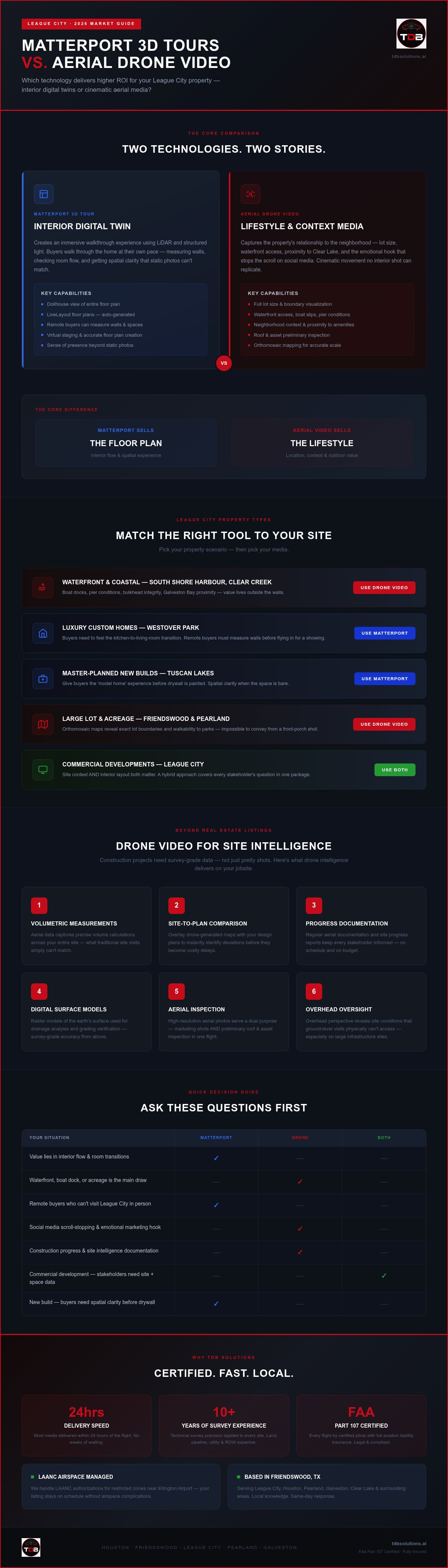
Choosing between a Matterport 3D tour vs aerial drone video League City depends on the specific story you need to tell. Matterport builds a digital twin. It allows users to walk through a home at their own pace. It creates a sense of presence that static photos can't match. On the other hand, aerial photography captures the property's relationship to the neighborhood. It shows how close you are to Clear Lake or local schools. While Matterport wins on interior flow, drone video provides the emotional hook for social media. It stops the scroll with cinematic movement.
Modern 3D virtual tour technology has evolved far beyond simple panoramic photos. It now uses LiDAR and structured light to map every inch of a room. This precision helps with virtual staging and accurate floor plan creation. We apply over 10 years of technical survey precision to ensure these digital twins are accurate. You get a reliable representation of the space, not just a pretty picture. Deciding on the right mix of Matterport 3D tour vs aerial drone video League City often comes down to the property's unique layout and location.
When Matterport is the Right Call
Matterport is the standard for luxury interiors where flow matters most. If you're selling a custom home in Westover Park, buyers want to feel the transition from the gourmet kitchen to the living area. It's essential for remote buyers who can't visit League City in person. They can measure walls and check if their furniture fits. Our scans generate accurate LiveLayout floor plans automatically. This saves you the time of manual measurements. It provides a technical layer of data that builds trust with serious prospects. The 3D model allows for a dollhouse view that makes the entire layout clear in seconds.
When Aerial Video Takes the Lead
Aerial video wins when the property's value lies outside the four walls. In South Shore Harbour, the lot size and professional landscaping are major selling points. You can't show a half-acre lot from the front porch. High-resolution photos from a drone also serve a dual purpose. They provide the marketing shots you need and act as a preliminary tool for roof and asset inspections. For properties on Clear Creek, capturing waterfront access and boat slips is non-negotiable. A drone shows the deep-water access that a ground-level shot simply misses. Our FAA Part 107 certified pilots ensure these shots are legal and crisp. We deliver most media within 24 hours of the flight. This speed keeps your listings moving without delays.
Matching Media to League City Property Types
League City features a mix of tight-knit residential blocks and sprawling waterfront estates. Deciding on a Matterport 3D tour vs aerial drone video League City requires you to analyze the site's unique strengths. A luxury condo near the Kemah Boardwalk needs a different strategy than a five-acre estate in Friendswood. You need to identify where the value lies before booking a shoot. Interior flow matters for some, while others are all about the outdoor lifestyle.
Waterfront and Coastal Listings
In communities like South Shore Harbour, the water is the main attraction. Drones show the proximity to Galveston Bay and Clear Lake. You can capture the full story of boat docks and pier conditions from angles ground shots miss. High-resolution photos even help buyers assess bulkhead stability from a distance. Following National Association of REALTORS® drone guidelines, aerial views significantly influence buyer interest by providing this outdoor context. We ensure every flight is performed by FAA Part 107 certified pilots. We handle the LAANC authorizations for restricted zones near Ellington Airport so your listing stays on schedule.
Master-Planned Communities and Acreage
Master-planned developments like Tuscan Lakes rely on spatial clarity. For new builds, Matterport provides that 'model home' experience. It allows buyers to feel the layout before the drywall is even painted. For larger lots, we use drones to map out boundaries with an orthomosaic. This provides a geometrically corrected image for accurate scale. It shows the walkability to local League City parks and neighborhood amenities. If you need to document a large project, our site intelligence services provide the data needed to keep stakeholders informed. Most media is delivered within 24 hours of the flight.
Commercial developments in League City often require a hybrid approach. You need Matterport for interior site documentation and drone video for site intelligence. Because League City sits under Ellington Field and NASA flight paths, compliance is critical. We use Remote ID compliant drones to broadcast required telemetry. This keeps your project legal and avoids fines. Our team brings 10+ years of survey experience to every jobsite. We ensure technical precision in every data set. We don't just take photos; we provide actionable data for construction delay prevention.
Beyond the Listing: Using Drone Video for Site Intelligence
While the debate of Matterport 3D tour vs aerial drone video League City often focuses on marketing, the real power for developers lies in site intelligence. This practice embeds real-time project data into your workflow to show ongoing progress. It isn't just about a pretty video. It's about survey-grade data that allows for accurate volumetric measurements. You can track dirt moving across a site with technical precision. This level of detail identifies deviations before they become costly build delays.
High-Performance Video Production builds trust with stakeholders. They don't have to take your word for it. They can see the progress from their office. By overlaying drone-generated maps with design plans, you perform a site-to-plan comparison. This catches grading errors or drainage risks early. Our team brings 10+ years of professional survey experience to every jobsite. We ensure the data you receive is actionable and precise. We don't just fly; we provide commercial drone intelligence that keeps your project on schedule.
Construction Progress Tracking
Regular aerial documentation replaces manual site visits. It saves you time and reduces travel costs. We provide construction intelligence drone data that offers a geometrically corrected view of the entire site. These orthomosaic maps provide a uniform scale for accurate measurements. You can measure distances, areas, and volumes directly from the imagery. Most project deliverables are completed within 24 to 48 hours of the flight. This speed ensures you're making decisions based on current reality, not last week's news.
Technical Inspections and Safety
Safety is a priority on any League City jobsite. Drones allow you to perform an aerial inspection of roofs and high structures without scaffolding. This reduces risk and speeds up the inspection process. Every flight we perform adheres to FAA commercial drone regulations. Our FAA Part 107 certified pilots ensure legal and safe operations in every flight. We handle the technical heavy lifting so you can focus on your craft.
We carry specialized aviation liability insurance for your protection. Whether you're checking for storm damage or verifying a warranty, high-resolution photos allow for close inspection without loss of clarity. You get a clear record of asset conditions. This documentation is vital for insurance claims and long-term maintenance planning. It's a reliable way to keep your project on track and your team safe. We deliver these results with the speed and reliability that traditional methods simply can't match.
Integrating Media into Conversion-Focused Features
High-quality media is useless if it kills your site speed. A heavy Matterport embed or unoptimized 4K drone video can drive bounce rates up instantly. When you weigh the benefits of a Matterport 3D tour vs aerial drone video League City, you must consider the technical delivery. Conversion-Focused Features like inquiry forms and interactive maps only work if the page loads fast. We build sites that prioritize core web vitals while showcasing high-resolution photos. You need a fast, responsive interface to keep prospects engaged.
Strategic placement is everything. You don't just dump a 3D tour at the top of a page and hope for the best. We place interactive elements where they naturally guide the user toward a call to action. We use Retargeting Creative to keep your League City project top-of-mind for prospects who have already viewed your listing. This ensures your marketing spend isn't wasted on one-time visitors. Our team ensures every asset serves a specific purpose in your sales funnel.
Mobile-First Web Design for Media
Most League City buyers search for properties on their phones. Your media must load instantly on 5G networks. We optimize every asset to ensure it doesn't drag down performance. This is the core of houston web design. We ensure interactive 3D tours are interaction-ready without long lag times. By focusing on mobile-first conversion, we help you reach buyers where they are. We use lightweight preview images that trigger the full tour only when the user is ready. This approach keeps your site fast and your bounce rate low.
Social Media and Ad Strategy
Static images don't stop the scroll anymore. You need movement to capture attention. Short-form drone clips are perfect for Instagram and Facebook ads. They provide a quick visual hook that showcases the property's scale. We often combine these tech tours with mic'd up interviews to add a human element to the data. This builds trust and authority with your audience. We use Geo-targeting to push these ads specifically to buyers in League City and Pearland. This precision ensures your media reaches the right people at the right time.
Carousel Ads allow you to showcase multiple aerial angles in a single swipeable unit. You can show the front elevation, the backyard, and the proximity to the water all in one ad placement. This maximizes engagement and gives buyers a complete picture of the property. If you want to turn your project media into a lead-generation machine, connect with our team for a strategy session. We deliver professional results with a turnaround time of 24 to 48 hours. You get the speed you need to stay ahead of the competition.
Why TDB Solutions Delivers Superior League City Media
Choosing between a Matterport 3D tour vs aerial drone video League City shouldn't be a gamble. You need a partner who understands the local geography, from the restricted flight paths near NASA to the specific lighting challenges of Galveston Bay waterfronts. We don't just provide pretty pictures. We deliver technical assets that drive business growth. Our team is based in Friendswood, giving us a "boots-on-the-ground" advantage in League City, Pearland, and the surrounding metro area. We know the market because we live here.
Every mission we fly is performed by FAA Part 107 certified pilots. We carry specialized aviation liability insurance to ensure professional peace of mind on every jobsite. Whether you are documenting a new construction project or listing a luxury estate, you get a specialist, not a generalist. We handle the technical heavy lifting so you can focus on closing deals. Our results speak for themselves; we move your projects from being overlooked to having high visibility.
The Survey-Grade Difference
Founder Dillon Bates brings over 10 years of professional survey experience to every project. This technical background changes how we approach media production. We apply technical survey precision to every site architecture mission we undertake. While competitors focus only on aesthetics, we provide actionable data for roof assessments and drainage analysis. We use professional-grade equipment to ensure your site intelligence is accurate and reliable. This survey-grade data allows you to spot grading deviations before they cause build delays. You aren't just getting a Matterport 3D tour vs aerial drone video League City comparison; you're getting a comprehensive intelligence report.
Speed and Reliability
In the fast-paced 2026 market, slow turnaround times delay listings and stall projects. We deliver most media within 24 hours of the flight. All project deliverables are typically available within 24 to 48 hours. You don't have time to wait for weeks. You need results now. We provide direct communication with our clients. When you call, you get a real person, not a bot or a runaround. We pride ourselves on being a reliable ally for local business owners and developers. Ready to book? Contact TDB Solutions today to schedule your flight. We provide the speed and technical expertise that traditional site visits and generic media teams simply can't match.
Dominate Your Next League City Project
Winning in the 2026 real estate and development market requires the right technology for the right property. Indoor spaces demand immersive digital twins, while waterfront lots and large commercial builds require high-resolution aerial views. Balancing a Matterport 3D tour vs aerial drone video League City means understanding where your property's value sits. You do not have to choose blindly when you partner with a specialist who understands local airspace and technical data precision.
We combine 10+ years of survey experience with FAA Part 107 certified pilots to deliver actionable site intelligence and high-performance media. Most standard shoots are delivered within 24 hours, ensuring your project stays on schedule without delays. We handle the technical heavy lifting so you can focus on growing your business. Ready to upgrade your marketing media and data accuracy? Get a professional quote for your League City project today and experience the difference that certified expertise brings to your jobsite.
Frequently Asked Questions
Do I need a special permit for drone video in League City?
Commercial drone flights in League City require an FAA Part 107 certified pilot. You don't need a city-specific permit, but you must have federal authorization. Because parts of League City sit under Ellington Airport and Hobby Airport airspace, we secure near-real-time LAANC approval before every flight. This ensures your project is legal and compliant with Remote ID regulations. We handle all the technical paperwork so you can focus on your property.
Can Matterport tours be used for outdoor spaces in Texas?
Yes, the Matterport Pro3 hardware allows for outdoor scanning in direct Texas sunlight. Unlike older infrared units, the Pro3 uses LiDAR to capture depth data up to 100 meters away. This makes it ideal for showcasing League City waterfronts, landscaping, and outdoor living areas. You get a complete digital twin that includes both the interior flow and the exterior relationship to the lot. It is a reliable solution for coastal properties.
How fast can I get my drone photos and 3D tour back?
We prioritize speed and reliability for every League City mission. Most media shoots are delivered within 24 hours of the flight. You can expect all project deliverables, including 3D models and high-resolution photos, within 24 to 48 hours. This fast turnaround prevents listing delays and keeps your construction team informed with real-time site intelligence. We provide direct communication throughout the process so you never get a runaround from bots.
Is Matterport better than a cinematic walkthrough video?
Neither is better; they serve different purposes. Matterport sells the spatial layout, allowing users to walk through a home at their own pace. Cinematic video creates an emotional hook and is better for social media engagement. When comparing a Matterport 3D tour vs aerial drone video League City, the winner is usually a hybrid approach. Using both ensures you capture the interior flow and the neighborhood lifestyle that buyers in Galveston County demand.
What is the difference between aerial photography and an orthomosaic?
Aerial photography focuses on aesthetic shots for marketing and social media. An orthomosaic is a technical asset created by stitching multiple photos into a geometrically corrected map. This provides a uniform scale for accurate measurements, similar to a top-down survey view. It is essential for site-to-plan comparisons and volumetric measurements on construction sites. We apply over 10 years of survey experience to ensure these data sets are technically precise for every mission.
Are your pilots FAA Part 107 certified for League City flights?
Every flight we conduct is performed by FAA Part 107 certified pilots. We carry specialized aviation liability insurance for your protection. Safety and compliance are non-negotiable, especially in League City where we operate near active flight paths for Ellington Field and NASA. You get professional peace of mind knowing that your aerial data is being collected by experts who prioritize legal and safe operations on every single mission we fly.
Can you integrate my 3D tour into my existing website?
Yes, we can embed your 3D tour directly into your current site. We also offer custom mobile-first websites designed specifically to handle large media files without sacrificing speed. Our team optimizes every embed to ensure your core web vitals remain strong. This prevents high bounce rates and ensures that your Matterport 3D tour vs aerial drone video League City assets actually convert visitors into qualified leads. We focus on results-oriented digital growth.
How does drone data help with construction delay prevention?
Drone data provides site intelligence that traditional site visits can't match. By conducting regular progress tracking, we identify deviations from the original design plans early. This site-to-plan comparison catches grading errors or drainage risks before they become expensive problems. We deliver survey-grade data that allows project managers to make informed decisions based on current reality. This technical oversight keeps your League City build on schedule and within your planned budget.


