

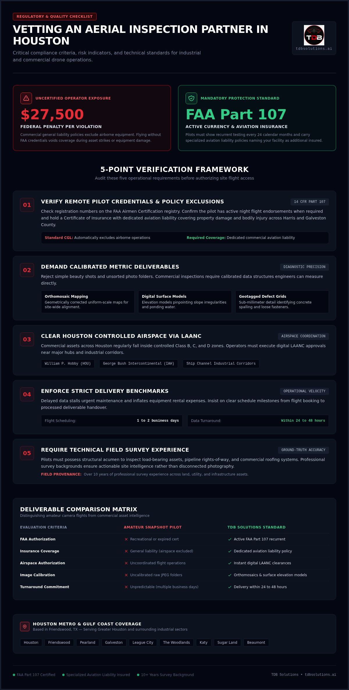
Hiring an uncertified drone operator won't just leave you with useless raw files; it exposes your jobsite to federal civil penalties up to $27,500 per violation. When elevated assets or commercial roofing systems demand inspection, you need an aerial inspection company Houston TX builders and property managers can rely on to keep personnel safely off dangerous scaffolding and lifts. You already know that waiting days for amateur snapshots stalls critical repairs, creates compliance headaches, and wastes payroll.
You need dependable data and clear visual evidence, not technical excuses. Use this vetting checklist to hire an insured, FAA-certified drone inspection partner in Houston who can handle complex industrial environments and strict flight authorizations. Ahead, you'll discover how to audit specialized aviation liability policies, clear controlled airspace near local airports, and guarantee delivery of high-resolution photos and orthomosaics within 24 to 48 hours of your flight.
Key Takeaways
- Confirm that your drone operator carries active FAA Part 107 certification and specialized aviation liability insurance to shield your site from costly liabilities and federal fines.
- Partner with an aerial inspection company Houston TX managers trust for technical deliverables, including calibrated high-resolution photos and orthomosaic maps, instead of raw snapshot files.
- Verify that your inspection team uses LAANC for fast airspace clearances across controlled zones near William P. Hobby Airport, George Bush Intercontinental, and coastal industrial corridors.
- Demand turnaround times within 24 to 48 hours of flight, giving your maintenance or construction team actionable defect data without renting expensive lifts or scaffolding.
- Choose a local team with over 10 years of professional survey experience to ensure structural and roofing assessments translate into dependable site intelligence.
Checklist Item 1: Verify Pilot Licensing and Aviation Insurance
Hiring a contractor who flies drones as a sideline hobby is a recipe for project disruption. Commercial industrial inspection requires rigorous regulatory compliance and documented jobsite safety protocols. When vetting an aerial inspection company Houston TX operators offer, your first move is auditing their legal credentials and risk documentation. Never sign a work order until you verify these non-negotiable protections.
FAA Part 107 Credential Checks
Demand the pilot's remote pilot certificate number before confirming a flight date. Under 14 CFR Part 107, commercial privileges require recurrent training every 24 calendar months through the FAA Safety Team system. You can verify certificate validity directly on the official FAA Airmen Certification database. Make sure the pilot demonstrates active currency, including night flight endorsements if your facility requires off-hours visual scanning.
Dedicated Aviation Liability Insurance
Standard commercial general liability specifically excludes airborne equipment operations. If an uncrewed aircraft strikes an industrial flare stack or drops onto parked equipment, standard policies deny the claim immediately. Request a Certificate of Insurance showing dedicated aviation liability coverage. Require the provider to list your business as an additional insured with clear limits covering property damage and bodily injury across Harris or Galveston County jobsites.
Field Survey and Technical Background
A reputable aerial inspection company Houston TX site managers trust brings disciplined technical oversight to visual asset assessments. Operators should understand how to translate raw flight runs into metric intelligence through aerial photogrammetry and 3D modeling rather than taking disconnected beauty shots.
Look for flight teams with documented backgrounds in civil infrastructure, pipeline corridors, and structural alignment. Use this initial screening checklist before clearing any pilot for site access:
- Active Remote Pilot Certificate: Verify currency on the FAA registry to ensure the pilot hasn't lapsed on their 24-month recurrent testing.
- Aviation-Specific Policy: Confirm dedicated flight liability coverage that explicitly includes commercial drone operations on industrial sites.
- Jobsite Hazard Controls: Review their documented pre-flight safety checklists, visual observer assignments, and emergency return-to-home procedures.
- Structural Acumen: Ensure the team understands site plans so they capture critical structural joints and load-bearing assets accurately.
Reject hobbyists instantly. Professional visual data collection demands technical precision, strict regulatory compliance, and verified insurance protection.
Checklist Item 2: Demand Technical Deliverables Over Simple Photos
Amateur drone pilots dump folders of disorganized JPEG files on your desk and call it an assessment. That leaves your maintenance crew guessing where a defect sits on a 100,000-square-foot roof. An expert aerial inspection company Houston TX operators rely on provides calibrated, spatial records instead of simple beauty shots. Diagnostic asset evaluations require data structures that your engineers can measure, export, and act upon immediately.
High-Resolution Photos and Defect Tagging
Demand oblique-angle, high-resolution photos that isolate minute material compromises. A flight team operating under verified FAA Part 107 remote pilot certification must capture sub-millimeter details, from backed-out mechanical fasteners to hairline concrete spalling. Insist on geotagged images organized into structural grids. This system lets your repair teams locate damaged seams or rusted parapet caps without searching through hundreds of unsorted files.
Orthomosaic Mapping and Elevation Overlays
Require a geometrically corrected orthomosaic map for any expansive facility. This stitched, uniform-scale image gives your project managers a top-down view of the entire asset footprint. When paired with digital surface models, these maps reveal subtle slope irregularities, ponding water, and low spots that trap debris around critical drains. You can learn more about assessing complex structures safely by exploring drone inspection without scaffolding across commercial properties.
Site Intelligence Integration
Raw photos don't help if they sit isolated outside your maintenance software. High-value data should integrate directly into your computer-aided design (CAD) programs or project management tools to build a permanent condition baseline. You can review how this modern aerial workflow compares against manual bucket-truck methods in our aerial inspection vs traditional inspection field guide.
Insist that your provider supplies these technical standards before authorizing deployment:
- Calibrated Orthomosaic Maps: Uniform scale aerial maps ready for area and perimeter measurements.
- Digital Surface Models: Elevation-encoded rasters that expose hidden drainage bottlenecks and gradient shifts.
- Spatial Defect Logs: High-resolution photos cataloged by coordinate or roof section for direct contractor dispatch.
- CAD and BIM Export Formats: Point cloud and surface deliverables compatible with Autodesk Revit and design platforms.
Upgrading your asset monitoring starts with reliable visual data. If you want structured data that protects your capital improvements, partner with TDB Solutions for precision visual documentation.
Checklist Item 3: Assess Local Houston Airspace and Weather Experience
Houston presents one of the most congested flight environments in the country. From commercial jet corridors to maritime industrial corridors, operating uncrewed aircraft here requires specialized airspace planning. National brokerages often farm out work to inexperienced pilots who get grounded by local flight restrictions. When you vet an aerial inspection company Houston TX commercial managers rely on, verify their boots-on-the-ground familiarity with regional airspace and Gulf Coast weather patterns.
Navigating Controlled Houston Airspace
Controlled airspace covers significant portions of the Houston metroplex. Multi-tiered Class B airspace blankets the regions surrounding William P. Hobby Airport (HOU) and George Bush Intercontinental (IAH), extending right down to the surface in critical commercial corridors. Southeast of the city, Class D airspace shields Ellington Field Joint Reserve Base (EFD) and Scholes International Airport at Galveston (GLS), while Class E transitions affect flight operations around Pearland Regional Airport (LVJ).
Your drone contractor must navigate these zones legally using the Low Altitude Authorization and Notification Capability (LAANC). Professional pilots secure automated LAANC approvals beneath UAS Facility Map ceilings within minutes. For heights exceeding grid limits, they submit safety coordination requests up to 90 days in advance. Unprepared operators show up on site only to discover their aircraft software geocaged, grounding your project instantly.
Gulf Coast Climate and Environmental Readiness
Texas Gulf Coast weather creates harsh operational challenges. Blistering summer heat degrades battery efficiency, while convective afternoon thunderstorms produce rapid microbursts. Sustained coastal winds across League City and Galveston test equipment stability. Commercial inspection aircraft handle sustained winds up to 22 to 27 mph before gimbal stabilization degrades, requiring seasoned pilot judgment to prevent blurred imagery.
Top operators adhere to rigorous flight control benchmarks like the NIST standardized aerial drone inspection test methods to confirm aircraft stability and pilot station-keeping around critical infrastructure. Ensure your prospective flight team demonstrates these regional capabilities:
- Established LAANC Proficiency: Seamless clearance execution across Hobby, Bush, Ellington, and Galveston airspace sectors.
- Industrial Corridor Clearance: Experience coordinating flights near Houston Ship Channel petrochemical plants and maritime facilities.
- High-Wind Stability: Flight protocols calibrated for coastal gust margins along Galveston County and Bay Area shorelines.
- Rapid Local Dispatch: Pilots based within Pearland, Friendswood, or Houston who can capitalize on clean morning flight windows.
Choosing an aerial inspection company Houston TX facilities trust means picking a partner who knows how to work around local flight grids and coastal weather shifts without delaying your schedule.
Checklist Item 4: Confirm 24-Hour Turnaround Times and Inspection Standards
Asset evaluations lose their value when reports sit in processing limbo for weeks. When roof leaks threaten production inventory or structural shifts compromise jobsite safety, every hour of delay multiplies your repair costs. Choosing an aerial inspection company Houston TX commercial managers trust means demanding concrete delivery windows, not open-ended commitments. You need an operational partner structured to collect data swiftly and upload deliverables within hours, not weeks.
Inspection Scheduling and Rapid Deployment
Top providers book and fly site missions within 1 to 2 business days of your call. Nationwide drone broker networks waste precious time re-assigning requests to distant freelancers, often creating miscommunications over safety waivers or site entry rules. Direct, regional operators confirm airspace authorization and asset targets immediately. That direct line keeps your facility maintenance timelines on track and eliminates costly downtime for tenant operations below.
Fast Deliverable Windows
Insist on receiving your processed visual files within 24 to 48 hours of flight completion, with most standard shoots delivered within 24 hours. Your team should inspect calibrated orthomosaics, check zoom-in defect tags, and forward documented proof straight to insurance adjusters or general contractors. You can explore how rapid deliverable windows speed up preventative maintenance in our guide to drone roof inspection Houston asset workflows.
Make sure your prospective partner follows this reliable five-step operational workflow from initial booking to final report handoff:
- Step 1: Scope and Clearance: Confirm project scope, target assets, and FAA flight authorizations within one business day.
- Step 2: Low-Impact Data Capture: Execute on-site automated grid flights rapidly without interrupting active tenants or staging heavy ground machinery.
- Step 3: Rapid Cloud Processing: Process raw flight captures into calibrated files delivered within 24 to 48 hours.
- Step 4: Quality Review: Access processed orthomosaic maps and high-resolution photos through secure client portals for cross-team review.
- Step 5: Contractor Action: Hand off clear defect evidence to estimators, roofing specialists, or warranty adjusters for immediate repair dispatch.
Fast data turnaround keeps your facility safe and your projects moving forward. If you are ready to eliminate scheduling bottlenecks on your upcoming project, book an inspection with TDB Solutions today.
Checklist Item 5: Choose Local Boots-on-the-Ground Expertise with TDB Solutions
A vetting checklist only protects your jobsite if your inspection partner executes it with precision. When you need an aerial inspection company Houston TX contractors and asset managers trust, working with a direct local operator beats dealing with national broker networks every time. TDB Solutions operates directly out of Friendswood, serving properties and industrial jobsites across Greater Houston, Pearland, League City, and Galveston County.
10+ Years of Field Survey Precision
Founder Dillon Bates brings over 10 years of land, pipeline, utility, and right-of-way survey experience to every commercial flight. While TDB Solutions does not provide licensed land surveying, that decade of field measurement discipline shapes how our FAA Part 107 certified pilots evaluate structural alignment, drainage gradients, and building envelopes. We turn visual flight data into clear, actionable site records. You can examine how our team tracks structural progress through our construction intelligence drone data workflow.
Direct Houston Contact and Fast Project Turnaround
National platforms route your requests through detached dispatch desks that know nothing about local airspace or coastal weather conditions. We take a different approach. When you reach out to our team, you speak directly with experienced pilots who answer calls the same day. Most inspections are scheduled and completed within 1 to 2 business days of booking, with processed files delivered within 24 to 48 hours of flight completion.
Partnering with TDB Solutions guarantees specific operational advantages for your commercial assets:
- Local Friendswood Operations: Direct regional presence eliminates travel markups and enables rapid dispatch across Harris and Galveston County.
- Specialized Aviation Insurance: Dedicated aviation liability coverage safeguards your property with certificates naming you as additional insured.
- Survey-Informed Technical Eye: Inspection routes planned by professionals with extensive backgrounds in civil infrastructure and site measurements.
- 24-Hour Delivery Standards: High-resolution photos and orthomosaics uploaded to secure portals within 24 hours of flight for most standard missions.
Stop risking your facility with uncertified operators or waiting weeks for raw files from distant brokers. Choose an aerial inspection company Houston TX leaders depend on for accurate visual diagnostics and rapid reporting. Protect your assets by taking action now: Schedule Your Houston Aerial Inspection with TDB Solutions.
Secure Your Commercial Assets with Precision Aerial Data
Hiring the right aerial inspection company Houston TX property managers depend on comes down to verified risk management and technical deliverables. Don't gamble with uncertified pilots who lack specialized aviation liability insurance or hand over disorganized folders of snapshot photos. Demanding active FAA Part 107 licensing, swift LAANC airspace authorizations, and delivery of calibrated orthomosaics within 24 to 48 hours protects your jobsite and keeps maintenance schedules on track.
You don't have to risk crew safety on scaffolding or wait weeks for critical defect findings. With over 10 years of professional survey experience applied to every flight, TDB Solutions provides the clear structural documentation your contractors need to act fast. Ready to gain total visibility over your facility? Schedule your aerial inspection with TDB Solutions today and put verified aerial intelligence to work on your site.
Frequently Asked Questions
Is an FAA Part 107 certification required for commercial drone inspections in Houston?
Yes, federal law under 14 CFR Part 107 strictly requires any commercial drone operator to hold an active Remote Pilot Certificate. Flying commercial inspection missions without it violates FAA regulations, exposing both the contractor and the site owner to severe civil penalties. Pilots must also complete recurrent knowledge testing every 24 calendar months. Always ask an aerial inspection company Houston TX contractors propose for documented certification before allowing flights on your jobsite.
Can an aerial inspection company operate legally near Houston airports?
Yes, certified operators can fly near major hubs like William P. Hobby Airport and George Bush Intercontinental using the FAA's Low Altitude Authorization and Notification Capability (LAANC). Professional pilots obtain automated clearance within pre-approved grid altitudes in controlled Class B, C, and D airspace. When your jobsite requires higher elevations or sits in restricted corridors around Ellington Field or Galveston, pilots submit manual coordination requests through the FAA portal ahead of time.
How fast can I expect to receive my aerial inspection deliverables?
Most professional commercial drone missions deliver processed inspection data within 24 to 48 hours of flight completion. Standard high-resolution visual shoots and raw orthomosaic models are typically uploaded to secure cloud portals within 24 hours. Because local operators manage their own flight schedules across Houston, Friendswood, and Galveston, you avoid the administrative delays common with third-party national broker networks, keeping your maintenance teams moving without friction.
What type of insurance should a commercial drone inspection company carry?
Commercial drone operators must carry specialized aviation liability insurance rather than standard business policies. General commercial liability policies almost universally exclude aviation-related damage and aircraft operations. A professional drone contractor should provide an active Certificate of Insurance that explicitly covers uncrewed aircraft operations, protects against jobsite bodily injury and property damage, and names your company as an additional insured before entering any industrial, retail, or commercial property.
Can drone inspections replace traditional scaffolding for building assessments?
Drone inspections eliminate the need for scaffolding, lifts, and swing stages during initial and routine visual evaluations. An experienced aerial inspection company Houston TX property teams hire can inspect multi-story facades, parapet walls, and high-pitch roofing systems safely from the ground. This drastically cuts fall hazards, prevents expensive equipment rental delays, and avoids tenant disruption while capturing calibrated visual data that pinpoints whether localized physical repairs are actually required.
What structural defects can high-resolution aerial inspection photos identify?
Calibrated aerial cameras capture sub-millimeter structural flaws across roofs, facades, and utility assets. Oblique high-resolution photos clearly identify backed-out fasteners, flashing failures, standing ponding water, open membrane seams, rust corrosion, cracked masonry, and loose parapet coping. When processed into digital surface models and orthomosaics, these detailed visual captures provide your maintenance team with spatial defect maps that verify structural integrity and document warranty claims accurately.


