

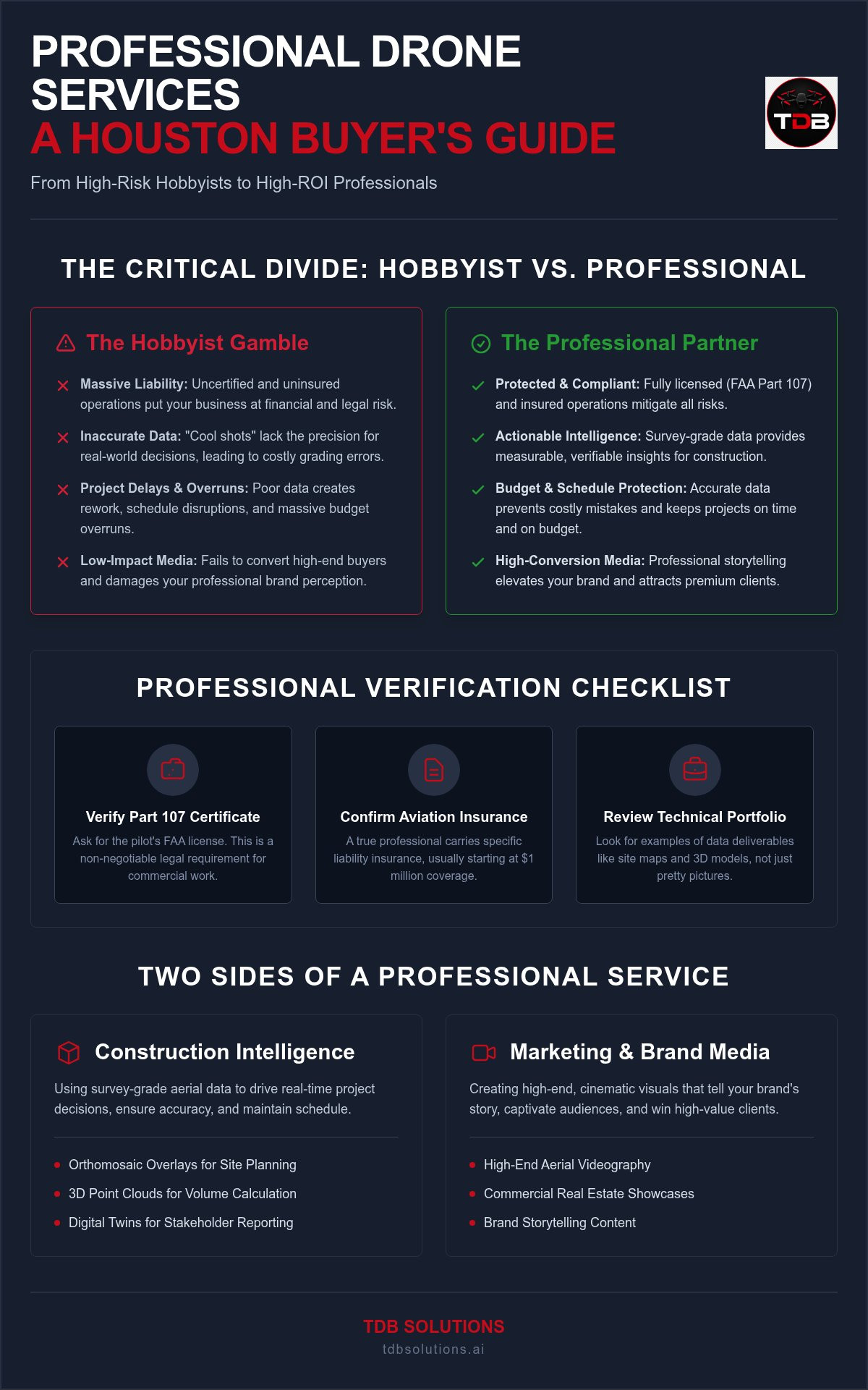
Hiring a hobbyist with a drone isn't a business strategy; it's a massive liability. In a city where the airspace is as crowded as the 610 at rush hour, the difference between a "cool shot" and actionable construction intelligence is everything. You've likely seen the fallout of poor planning. Inaccurate data leads to grading errors. Project delays. Budget overruns. Uncertified pilots risk five-figure FAA fines. Low-budget video fails to convert high-end buyers. It's frustrating to pay for technology that creates more problems than it solves.
Finding the right professional drone services Greater Houston doesn't have to be a gamble. You deserve a partner who understands that survey-grade data accuracy saves days on a job site and that professional branding builds long-term authority. This 2026 buyer's guide provides the roadmap to move from uncertainty to high visibility. We'll break down the essentials of legal compliance, technical data requirements, and high-impact media production. By the end, you'll know exactly how to choose a specialist who protects your bottom line while elevating your brand.
Key Takeaways
- Learn why FAA Part 107 certification is the baseline for legal safety and how high professional standards prevent expensive project delays.
- Differentiate between standard aerial photography and technical construction intelligence that delivers survey-grade data for site oversight.
- Identify how to vet professional drone services Greater Houston by aligning specific deliverable formats and sensor technology with your business outcomes.
- Evaluate the ROI of drone-based aerial inspections compared to traditional methods like manual scaffolding or ground-based site walks.
- Discover how bridging the gap between technical data and mobile-first marketing media creates a dominant brand presence in the Houston market.
Why Expertise Matters: The Professional Drone Standard in Houston
Professional drone services Greater Houston aren't defined by the price of the hardware. They're defined by the accuracy of the output and the legality of the operation. Many businesses make the mistake of treating aerial media as a commodity. They hire the cheapest pilot with a camera and hope for the best. This approach ignores the three pillars of a professional standard: FAA compliance, technical data skills, and creative vision. A hobbyist sees a pretty picture. A professional sees data points, safety protocols, and business ROI.
TDB Solutions brings a unique edge to the Houston market. Our founder, Dillon Bates, has over 10 years of survey experience. This isn't just about flying; it's about understanding the ground beneath the drone. This background allows us to provide high-level construction intelligence that a standard creative pilot simply can't match. We understand site topography, grading, and project oversight. We turn raw pixels into actionable insights that prevent delays and protect your budget. We bridge the gap between technical data and high-conversion marketing.
The Legal Baseline: FAA Part 107 and Beyond
Commercial drone work requires federal certification. The FAA Part 107 license isn't a suggestion; it's a legal requirement for any flight intended for business use. Hiring an uncertified pilot exposes your company to massive liability. If a crash occurs or a privacy complaint is filed, the "I didn't know" defense won't stop the fines. Before signing a contract, use this verification checklist to protect your business:
- Verify the Part 107 Certificate: Ask for a physical or digital copy of the pilot's FAA license.
- Confirm Insurance Coverage: Professional pilots carry specific aviation liability insurance, usually starting at $1 million.
- Check the Portfolio: Look for technical data samples and aerial inspections, not just sunset photos.
Local Knowledge: Navigating Houston’s Complex Airspace
Houston's geography is unique. Our work spans from the coastal winds of Galveston to the industrial hubs of Pearland and League City. This diversity requires deep local knowledge of the National Airspace System. We frequently operate near William P. Hobby (HOU) and George Bush Intercontinental (IAH). These zones require specific flight authorizations. We use the Low Altitude Authorization and Notification Capability (LAANC) and manual FAA waivers to ensure your project stays on schedule. We handle the paperwork and the permissions. Your site stays compliant. Your data stays on track.
Service Categories: Construction Intelligence vs. Marketing Media
Professional drone services Greater Houston fall into two distinct buckets: technical data and creative media. Most agencies pick a side. They either focus on engineering specs or pretty pictures. This binary choice forces business owners to juggle multiple vendors. It creates fragmented workflows and inconsistent results. TDB Solutions bridges this gap. We provide the "boots-on-the-ground" technical accuracy required for site oversight while delivering the high-end visuals needed for brand growth. You get one partner who understands both the job site and the digital marketplace.
Construction Intelligence and Progress Tracking
Traditional ground-based site walks are slow. They're also prone to human error and blind spots. Modern project oversight requires construction intelligence drone data to maintain a real-time, objective record of the job site. Construction Intelligence is the use of aerial data to drive real-time project decisions. It's about more than just checking boxes; it's about data-driven certainty.
We provide drone progress documentation construction managers use to verify subcontractor work and calculate stockpiles. This technical precision comes from Dillon's decade of survey experience. We don't just take photos. We create measurable maps. Technical deliverables include:
- Orthomosaic overlays for precise site planning and layout verification.
- 3D point clouds for accurate volume calculations and grading checks.
- High-resolution digital twins for remote stakeholder reporting and historical records.
Marketing Media and Brand Storytelling
Data wins the contract, but media wins the client. High-end aerial video is a non-negotiable for commercial real estate and brand visibility in 2026. We don't just fly; we tell a story. We combine stabilized 4K aerial assets with mic'd up business owner interviews to create high-conversion content. This approach transforms a generic drone shot into a powerful marketing asset that builds trust with your audience.
This media shouldn't live in a vacuum. It belongs at the center of a mobile-first web design Houston strategy. Slow-loading videos kill conversions on smartphones. We optimize every asset for speed and mobile engagement. If you're ready to stop being overlooked and start being seen, explore our media production and branding solutions. We handle the heavy lifting so you can focus on your craft.
Technical Evaluation: What to Ask Your Houston Drone Partner
Choosing professional drone services Greater Houston requires looking past the drone itself. It's about the sensor, the software, and the pilot's technical literacy. Many local operators use consumer-grade drones. These struggle with the heavy coastal winds from the Gulf. Industrial-grade platforms offer the stability needed for precision. You need to know if your project requires Photogrammetry for visual mapping or LiDAR for penetrating dense vegetation. One provides a visual context; the other provides high-density structural data.
Data Accuracy and Survey Standards
Real construction intelligence relies on survey-grade accuracy. This isn't achieved by just pressing record. High-precision mapping requires Ground Control Points (GCPs). These are physical markers on the site with known coordinates. Without them, your maps are just pretty pictures. They won't align with your CAD files or site plans. We focus on remote construction progress tracking that integrates directly into your existing project management workflow.
Georeferenced data sets are the gold standard for site oversight. They allow for repeatable flight paths that capture the exact same angles week after week. This consistency is the backbone of construction delay prevention aerial data. When you can overlay today's flight with last month's data, you spot deviations instantly. You move from reactive troubleshooting to proactive management. You distinguish between simple aerial photos and a true georeferenced data set.
Media Quality and Creative Direction
Marketing media has different technical requirements. Resolution is only half the story. Frame rates matter for high-end cinematic results. We shoot 4K at 60fps. This ensures smooth motion for your branding and prevents the stutter often seen in low-budget aerial video. High frame rates allow for professional slow-motion shots that highlight the scale of your commercial projects. But the work doesn't stop when the drone lands.
Professional post-production is where your brand identity takes shape. We handle the color grading and editing to ensure your assets align with your existing branding and graphic design. You should receive a comprehensive package of deliverables tailored to your needs. This includes RAW files for future use, edited 4K marketing videos, 3D models for site analysis, and PDF reports for quick stakeholder updates. Don't settle for a link to a Google Drive folder full of unedited photos. Demand a complete data and media solution that drives growth.
The ROI of Aerial Data: Cost Analysis for Houston Businesses
Professional drone services Greater Houston are often viewed as a luxury. This is a fundamental misunderstanding of the math. When you compare the cost of a single drone flight to the price of renting scaffolding and paying a crew for three days, the winner is clear. Aerial inspections remove the massive overhead of manual labor and the risk of human error. But the real ROI isn't just in what you spend. It's in what you don't lose. A single utility placement error or a foundation misalignment can easily cost $10,000 or more in rework. Aerial progress tracking catches these deviations before the concrete is poured. It turns a potential disaster into a minor correction.
Safety and Liability Savings
Safety is a major financial lever. Sending personnel onto commercial roofs in Pearland or Galveston carries inherent fall risks. Drones eliminate this liability entirely. You keep your boots on the ground while the sensors do the climbing. You get high-resolution documentation that serves as an insurance shield. If a dispute arises with a subcontractor or an insurance adjuster, you have a time-stamped visual history of the site. Speed is the second factor. We deliver data in hours. Traditional methods take days. Faster data means faster decisions and fewer project bottlenecks.
Marketing Conversion and Local Growth
Visual authority drives local growth. High-quality drone media increases time-on-site for your business website. It signals professional standards to potential clients before they even pick up the phone. On your Google Business Profile, aerial content stands out in a sea of low-quality smartphone photos. This visibility builds immediate trust. Stakeholders see transparent, high-quality updates. They feel confident in your progress and your brand.
Investing in professional drone services Greater Houston ensures your marketing assets work as hard as your field crew. You move from being just another contractor to being a market leader. If you're ready to stop guessing and start measuring your impact, view our construction intelligence and marketing packages. We handle the heavy lifting so you can focus on your craft.
Scaling Your Brand with TDB Solutions’ Integrated Approach
Most providers force you to choose between a data analyst and a videographer. TDB Solutions refuses that compromise. We're the only provider in the region bridging the gap between technical construction intelligence and high-impact digital marketing. This integrated approach ensures that the data used to manage your site also serves as the fuel for your brand's growth. We don't just hand over a hard drive and walk away. We turn your aerial assets into a cohesive website and branding package that positions you as the authority in your field.
Dillon’s background provides a distinct advantage here. With over 10 years of survey experience, he understands the technical nuances of a job site. This isn't just about flying a drone; it's about providing actionable insights for construction and real estate professionals. We serve the local community from Friendswood to League City with a pragmatic, boots-on-the-ground attitude. We understand the local market's unique challenges because we live and work here. We're your neighbors, your allies, and your technical specialists.
From Data to Digital Identity
Your aerial progress documentation shouldn't sit in a folder. It belongs on a custom mobile-first website that showcases your capabilities to potential clients. We build digital platforms that reflect the same professional standards you bring to the job site. A high-performing digital identity is built on three pillars:
- Mobile-First Design: Ensuring your site loads instantly and looks flawless on every device.
- Cohesive Branding: Developing a visual identity that communicates reliability and expertise.
- Conversion-Focused Media: Producing marketing content that turns Houston leads into loyal, long-term clients.
This strategy transforms technical data into a powerful sales tool. When a developer or homeowner visits your site, they see real-time proof of your progress. They see a company that invests in technology and transparency. This builds the trust necessary to win bigger contracts and scale your operations.
Your Partnership for Houston Growth
We provide more than just professional drone services Greater Houston; we provide strategic consulting for your long-term success. Whether you need ongoing support for multi-year project tracking or a complete marketing evolution, we're here for the long haul. We handle the technical heavy lifting so you can focus on your craft. Our goal is to move your business from being overlooked to having high visibility in a competitive market. Stop settling for fragmented services and start building a dominant brand presence. Schedule your Greater Houston drone consultation with TDB Solutions today and let’s get to work.
Elevate Your Houston Projects with Data-Driven Authority
Aerial technology is no longer a future concept; it's a current competitive requirement. Choosing professional drone services Greater Houston means moving beyond basic photography to embrace true construction intelligence and high-conversion media. You've seen how survey-grade data prevents costly rework and how cinematic storytelling builds brand authority. The right partner handles the technical complexity and FAA compliance so you can focus on building your legacy.
TDB Solutions brings a unique edge to every flight. With FAA Part 107 certification and over 10 years of survey experience, we ensure your data is as accurate as your vision. We're proud to serve Houston, Pearland, and Galveston with a boots-on-the-ground approach that delivers tangible results. It's time to stop being overlooked and start leading your market with precision and visibility.
Get a Professional Drone Service Quote for Your Houston Project
Your next project deserves the clarity and growth that only expert aerial insights can provide. Let's build something remarkable together.
Frequently Asked Questions
How much do professional drone services cost in Greater Houston?
Pricing for professional drone services Greater Houston depends on the project's scope, technical requirements, and flight frequency. A one-time marketing shoot has a different cost structure than recurring weekly construction progress tracking. We provide custom quotes based on your specific deliverables, such as 3D models or 4K video. Contact us directly for a transparent breakdown that fits your business goals and project needs.
Is FAA Part 107 certification required for all commercial drone flights?
Federal law requires FAA Part 107 certification for any drone flight that supports a business or commercial purpose. This includes marketing, roof inspections, and site mapping. Operating without this license isn't just a safety risk; it exposes your company to significant federal fines and legal liability. TDB Solutions is fully certified and insured, ensuring every operation remains compliant with current federal and local regulations.
What is the difference between drone photography and construction intelligence?
Drone photography provides a visual snapshot for marketing or basic inspections. Construction intelligence is a technical process that delivers measurable data points and georeferenced maps. While a photo shows you the site, construction intelligence allows you to calculate stockpile volumes, verify grading, and overlay CAD plans. It turns pixels into a tool for project management, leveraging Dillon's decade of survey experience for maximum accuracy.
Can drones fly near Houston airports like Hobby or IAH?
Drones can fly near major airports like Hobby (HOU) and George Bush Intercontinental (IAH), but it requires specific FAA authorization. We use the Low Altitude Authorization and Notification Capability (LAANC) system to secure real-time permissions for restricted airspace. For complex projects in urban Houston or near flight paths, we handle the manual waiver process. This ensures your project stays on schedule without risking airspace violations or safety incidents.
How quickly can I get drone inspection data for my property?
You can typically receive processed drone inspection data within 24 to 48 hours after the flight. While raw images are available almost instantly, technical deliverables like 3D models or orthomosaic maps require significant processing time. Our goal is to get actionable insights into your hands as fast as possible. This speed allows your team to make real-time decisions on site repairs or project adjustments without waiting days for manual reports.
Do I need to be present on the jobsite during the drone flight?
You don't need to be present on the jobsite during our flight operations. We coordinate with your site manager to ensure safety protocols are followed and the flight path doesn't interfere with active work. After the mission is complete, we upload the data to a secure platform for your review. This "boots-on-the-ground" approach allows you to focus on your core business while we handle the technical aerial data collection.
How does drone data help in preventing construction delays?
Drone data prevents delays by identifying site deviations early. When you compare weekly aerial maps against your original blueprints, you spot grading errors or utility placement issues before they require expensive rework. This remote oversight keeps stakeholders informed and ensures subcontractors are meeting milestones. By catching a $10,000 mistake during the foundation phase, you keep the entire project timeline and budget on track.
What industries in Houston benefit most from drone services?
Construction firms and commercial real estate developers gain the most from professional drone services Greater Houston. Property managers in Pearland and Galveston use our aerial inspections to assess roof health and storm damage without manual climbing. Additionally, marketing agencies and local business owners utilize our high-conversion video content to build trust and visibility. Any industry that relies on accurate site data or high-end visual branding can scale more effectively with our integrated approach.


