
What if every progress update gave your whole team the same clear view of the jobsite? Drone construction progress tracking Houston project teams can build into their workflow turns repeat aerial capture into a record they can compare over time. Occasional photos capture a moment, but inconsistent viewpoints make it harder to see what changed. Site teams and remote stakeholders may end up working from different snapshots.
Regular aerial documentation helps close that gap. It can show changing site conditions, document visible progress, and give teams a shared reference for review without adding unnecessary site visits. The value comes from a repeatable process and timely reporting, not just from getting a drone in the air.
In this article, you’ll learn what recurring aerial documentation can show, how to align capture with project milestones, and how site progress reports and volumetric measurements can support better-informed decisions. TDB Solutions is based in Friendswood and serves Houston-area projects. Founder Dillon Bates brings over 10 years of survey experience, and FAA Part 107 certified pilots perform each flight. Deliverables are typically available within 24-48 hours of the flight.
Key Takeaways
- Drone construction progress tracking Houston teams plan around project needs can turn repeat flights into updates that are easier to compare and review.
- Align capture scope and timing with milestones, site access, and the decisions your team needs to make.
- Visual records, site progress reports, and volumetric measurements each help answer different questions about site conditions and work completed.
- Choose capture intervals by working backward from review dates and project decisions, rather than following a one-size-fits-all schedule.
- TDB Solutions provides Houston-area construction intelligence and aerial inspections, with project documentation tailored to your site needs.
Why drone construction progress tracking matters on Houston job sites
A Houston jobsite can change while owners, project managers, and other decision-makers work elsewhere. A site visit gives one person a view at one moment. A phone photo may capture a detail but leave out how that area connects to the rest of the work. When each person relies on separate notes or images, it can be harder to review the same conditions and discuss progress from a shared reference.
Drone construction progress tracking Houston teams can use starts with a planned record, not simply a flight. The goal is clearer visibility over time: aerial documentation that helps authorized stakeholders review what changed, what remains visible, and which areas may need closer discussion. It supports coordination, but it doesn’t guarantee delay prevention or replace decisions made by the project team.
What construction progress tracking means beyond drone photos
Construction progress tracking means capturing aerial documentation on a planned basis so teams can review site conditions across project dates. It differs from a one-time promotional flight, which may prioritize a polished image over a useful comparison. With a repeatable approach, the team can document similar areas and viewpoints over time, making visible changes easier to spot and discuss.
That record can turn a broad question such as “How is the site moving?” into a focused review of specific work areas. Aerial vehicles have applications across multiple industries; the Unmanned Aerial Vehicle (Drone) Applications overview provides broader context. On a construction project, practical value comes from how the documentation fits into the team’s review process.
Why Houston project teams need clear overhead visibility
Active projects involve people with different responsibilities and schedules. A project manager may be on site while an owner or another authorized stakeholder reviews updates remotely. Shared overhead documentation gives them a common visual reference, helping conversations focus on observable site conditions instead of relying only on separate notes or memories.
Local work varies. A project in Houston may have different access needs and surrounding conditions than a site in Friendswood, Pearland, Galveston, or League City. The point isn’t to assume every job faces the same constraints. Plan documentation around the site and the people who need to review it.
Use the aerial record as a practical communication aid. Project managers can compare visible areas across captures, owners can follow site changes remotely, and other authorized stakeholders can review the same documented view. That shared context can make questions more specific and help teams identify where they need additional information. The imagery alone doesn’t establish whether work meets a design or contract requirement.
For useful tracking, define what the team needs to see and who needs access to the updates before capture begins. A consistent record gives the project a clearer visual history than disconnected images, while keeping the focus on informed review rather than promises about outcomes.
How Houston drone progress tracking turns a flight into a project update
A useful aerial update takes more than capturing images. Your project team needs a clear review question, a capture plan that fits the site, and deliverables that support a specific discussion. For drone construction progress tracking Houston projects can act on, connect those steps so the flight produces a purposeful update, not just a folder of files.
Plan the capture around the question the team needs answered
Begin by identifying the area to document, the visible work the team wants to review, and the reason for the update. A milestone review may call for broad site context. Another check-in may focus on one work zone or material area. Clear objectives keep the capture relevant and give stakeholders a practical frame for interpreting the documentation.
Next, coordinate capture timing and scope with the milestone and site access. A flight planned around a review date can give participants a shared visual reference for discussion. Site activity and access arrangements can also shape which areas the pilot can document during a visit. Planning these details in advance aligns expectations and keeps the update focused on project needs.
Turn aerial documentation into a review-ready update
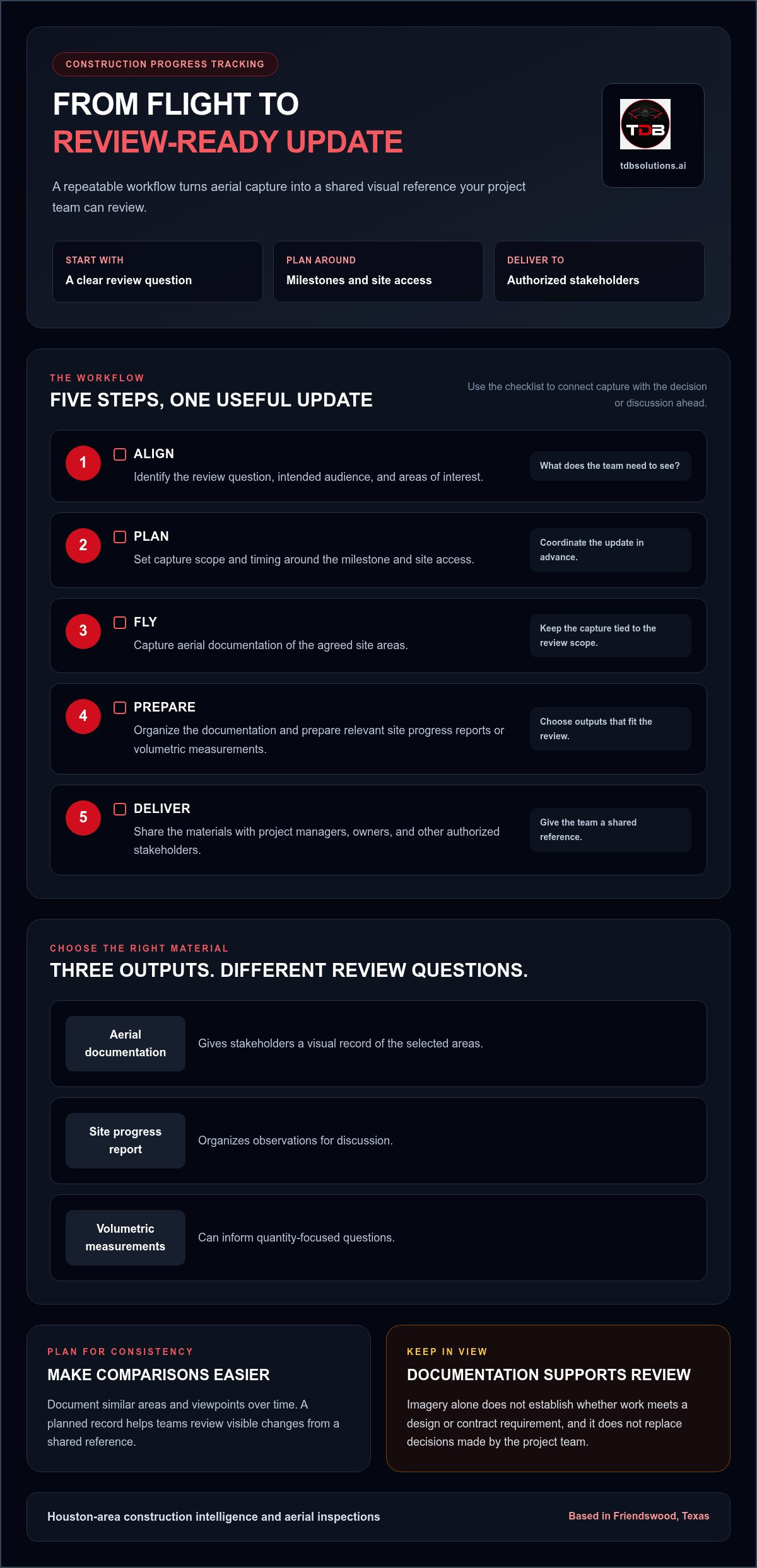
The workflow moves through five practical steps:
- Align. Identify the review question, intended audience, and areas of interest.
- Plan. Set the capture scope and timing around the milestone and site access.
- Fly. Capture aerial documentation of the agreed site areas.
- Prepare. Organize the documentation and prepare relevant site progress reports or volumetric measurements.
- Deliver. Share the materials so project managers, owners, and other authorized stakeholders can review them.
Each output supports a different kind of review. Aerial documentation gives stakeholders a visual record of the selected areas. A site progress report organizes observations for discussion. Volumetric measurements can inform quantity-focused questions. Together, they give the team material to review remotely while keeping attention on what the documentation can show.
Keep the update clear and tied to its purpose. Identify the capture date and areas covered, then direct reviewers to the details relevant to the project discussion. That context helps stakeholders interpret the material without treating it as a substitute for other project records or decisions. For more context on how drone data supports project oversight, explore construction intelligence drone data.
If your team wants to shape a process around its site and review needs, explore TDB Solutions construction intelligence for Houston-area projects.
What construction drone deliverables show, and how to read them
A drone deliverable is most useful when you know what question it can help answer. Aerial views support visual review, site progress reports organize observations, and volumetric measurements provide quantity-focused information. These outputs serve different purposes. They can give your team a clearer basis for discussion, but they don’t replace engineering review, certify work, or guarantee a particular level of measurement accuracy.
Aerial photos and reports for reviewing visible site changes
Overhead views can show the layout of visible work areas and how site conditions appear on the capture date. Compare them with earlier documentation to review changes in areas such as staging or active work zones. A site progress report organizes observations for project discussions, helping remote stakeholders focus on the same documented conditions. Imagery can inform a review, but it doesn’t prove schedule compliance or establish the quality of completed work.
| Deliverable | What it can help your team review | How to interpret it |
|---|---|---|
| Visual documentation | What site areas and visible conditions look like on the capture date | Compare views over time, keeping the capture scope in mind. |
| Site progress report | Which documented observations should guide a project discussion | Use it as an organized record, not as a certification of work. |
| Volumetric measurements | Quantity-focused questions about relevant site materials or areas | Review them in the context of the project question and measurement scope. |
For drone construction progress tracking Houston teams should match each output to the review at hand. If a stakeholder needs to understand visible site changes, visual documentation may be the clearest starting point. If the discussion centers on observations across the site, a report can help structure it. If the question concerns quantities, volumetric measurements may be relevant. No single deliverable answers every project question.
Volumetric measurements and mapping terms in context
Volumetric measurements focus on quantities, giving a team information to consider when reviewing a relevant material or site-area question. Interpretation depends on the project scope and what the measurement is intended to address. Don’t treat a number by itself as proof of a design condition or construction requirement.
An orthomosaic is a geometrically corrected aerial image made from multiple photos, adjusted to provide a uniform scale. Digital surface models are raster models representing the earth’s surface. These terms describe types of mapping data. Define the intended output and scope for your project so the team knows what data it will review.
Before reviewing any output, identify its purpose, capture scope, and limits. That keeps the discussion grounded in what the documentation actually shows and helps your team decide whether it needs another form of review.
Plan a useful drone tracking cadence around Houston project milestones
A useful capture cadence starts with project decisions, not a preset calendar. For drone construction progress tracking Houston teams can act on, first decide what each update needs to help you review. Then work backward from review dates and milestones to choose capture intervals that fit the project. A fixed frequency may produce images without answering the questions your team actually has.
Match capture timing to the project's changing work
Consider where the project is changing and when a current visual record would help your team assess that change. A milestone with visible work across several site areas may call for a capture close enough to the review date to inform discussion. During a quieter phase, the team may decide that a different rhythm makes more sense. Neither approach is universal. Let project goals and site conditions guide the plan.
Use these planning questions to set a practical starting point:
- What decision is coming up? Identify the review or project discussion that needs current site documentation.
- Which milestone matters? Choose the phase or visible change the team wants to review.
- Which areas need coverage? Focus the capture scope on locations connected to that decision.
- When will stakeholders review it? Choose timing that makes the documentation useful for the planned review.
Revisit the plan as work progresses. If the next milestone shifts or the team’s review needs change, the capture interval may need to change too. A milestone-first approach connects each planned visit to a purpose rather than treating recurring flights as an end in themselves.
Coordinate site access and local flight conditions
Timing also depends on whether the planned areas can be accessed and documented as intended. Site activity, access arrangements, and weather can affect a planned capture. Coordinate with the project team before the flight so the scope reflects current site conditions and the right people understand which areas are being documented. If conditions change, the planned timing may need to shift. Avoid building a review plan around an assumption that every visit will happen exactly as scheduled.
This coordination matters across projects in Houston, Friendswood, Pearland, Galveston, and League City. The local area doesn’t determine the right cadence. The project’s milestone dates, site access, and review priorities do. For teams with work across multiple locations, define priorities for each site rather than assuming one capture pattern suits every job.
Keep the plan simple: connect each capture to a decision, set the intended review date, and identify the site areas the team needs documented. This gives project stakeholders a clear basis for discussing timing and scope without promising automated collection or real-time monitoring. To plan aerial construction documentation around your project milestones, connect with TDB Solutions.
What to expect from TDB Solutions' Houston construction tracking
TDB Solutions provides construction intelligence and aerial inspections for Houston-area projects. The work starts with your project’s review needs: which site areas matter, what information stakeholders need, and how the update will support project discussions. This keeps capture and reporting focused on your site rather than assuming every project needs the same approach.
A local team with technical experience
Based in Friendswood, TDB Solutions works with construction teams across the Houston area. Founder Dillon Bates brings over 10 years of survey experience, and FAA Part 107 certified pilots perform each flight. That technical background helps shape a practical conversation about site access, work areas, and reporting priorities. Identify the views that matter to your team, then align the documentation with the project phase and intended review. The goal is a clear record that supports discussion, not a substitute for other project reviews or approvals.
Set up a project conversation with clear goals
To begin planning, share your site location, current project phase, and the areas stakeholders want to review. Note whether the team needs aerial documentation, a site progress report, or volumetric measurements for a specific question. TDB Solutions tailors capture scope and reporting to the project’s needs, helping you set clear expectations for the update.
For broader context on using aerial records in project oversight, explore Houston construction intelligence drone data. When you’re ready to discuss the site and your reporting priorities, Discuss your Houston project with TDB Solutions.
Make your next project review easier to act on
Give aerial documentation a clear place in your project’s communication process. Before the next review, decide who will bring the update forward, which discussion it should inform, and how the team will record follow-up actions. That step helps turn a visual record into a practical part of project coordination, not just another file to store.
With drone construction progress tracking Houston teams can build a more consistent view of site conditions and use it to support focused conversations. Shape the approach around your project’s goals, stakeholders, and reporting priorities. A planning discussion can clarify what you need documented and how the information should support your team’s review.
Discuss your Houston construction tracking needs with TDB Solutions and plan an approach that fits your project. Start with the questions your team needs to answer, then build a clearer path from aerial capture to useful project updates.
Frequently Asked Questions
Does drone construction progress tracking work for a small jobsite?
Yes, a small jobsite can benefit if an overhead view helps the team review a specific area or change. For example, a compact commercial build may need periodic views of its work zone and material staging area, even if the full site fits in one ground-level photo. The value of drone construction progress tracking Houston teams choose depends on the review question, not simply the site’s size.
Can drone progress records help owners review a project remotely?
Yes, aerial documentation can help an owner review visible site conditions without being physically present for every discussion. Before sharing an update, decide what the owner should focus on, such as a changed work area or site access condition. The owner can then bring specific questions to the next project meeting. Remote review supports communication, but it doesn’t replace coordination among the project team.
What happens if Houston weather disrupts a planned drone flight?
If weather affects a planned flight, coordinate a revised capture time with the project team. Keep the milestone review in view, but allow flexibility rather than treating the original date as guaranteed. For example, if a scheduled review depends on updated site imagery, stakeholders can adjust the review timing or discuss which existing records remain useful. Flight decisions depend on conditions at the time, not a fixed calendar alone.
Can drone progress tracking document interior construction work?
No, aerial progress tracking is suited to visible exterior areas that can be documented from above, not indoor conditions or concealed work. On a building project, an aerial view may show the exterior footprint and surrounding site activity, while it cannot show interior framing or work behind finished surfaces. Keep using your established methods to review indoor work, and treat aerial records as one view of the project.
Does every construction project need a 3D model for progress tracking?
No, a 3D model isn’t necessary for every project. If the team needs to review visible site changes, aerial documentation and a progress report may address the immediate question. A model makes sense when its format supports a defined project need and stakeholders can use it in their review. Start by naming the decision at hand, then choose an output that helps inform it.
Can aerial progress images prove that a project is on schedule?
No, aerial images alone can’t establish schedule status. They show visible site conditions at the time of capture, but they don’t explain work sequencing, off-site activity, or reasons a milestone may have shifted. For a schedule review, compare the imagery with the project’s milestone dates and other relevant records. Describe what the images show, then use the full project record to assess timing.


